METAR & TAF KLUM
Current METAR
Observed 18:55Z
KLUM 271855Z AUTO 30012G17KT 10SM CLR 35/23 A2967 RMK AO2 T03460226 PWINO
- Wind
- 300° @ 12G17 kt
- Visibility
- 10 SM
- Temp / Dew
- 35°C / 23°C
- Altimeter
- 29.67 inHg
- Clouds
- CLR
- Density alt
- 3,820 ft
- Ceiling
- Unlimited
- Rules
- VFR
Airport info & contacts
Manager on record, flight service, ARTCC, attendance schedule and pattern altitude — published by the FAA and refreshed every 28 days.
Location
- From city
- 3 NM E
- VFR sectional
- GREEN BAY
- ARTCC
- ZMP · MINNEAPOLIS
- NOTAM facility
- LUM (NOTAM-D)
Airport manager
- Name
- DARREL GIBSON
- Phone
- 715-220-6549
- Address
- 1400 INDIANHEAD DR., MENOMONIE WI 54751
Flight service · Hours
- FSS GRB
- GREEN BAY1-800-WX-BRIEF
- Attendance
- MON-FRI · 0800-1700
Frequencies
Tap any row to copy the frequency to your clipboard.
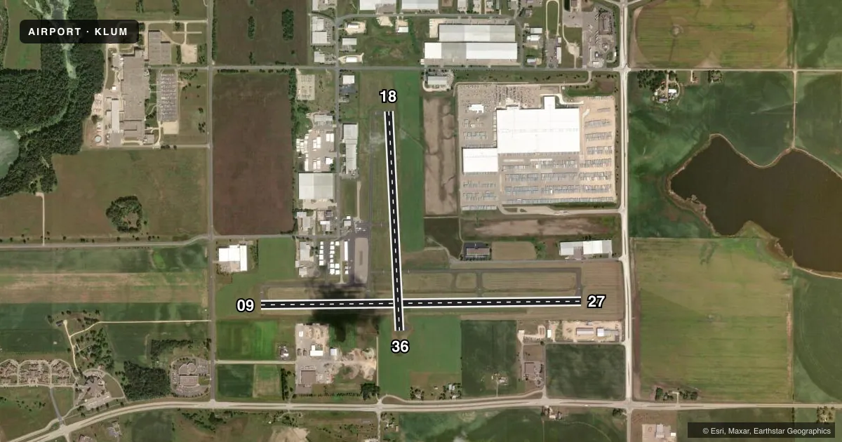
Runways & pattern
Full pagePattern entry · RWY 27
LEFT TRAFFIC| Runway | Heading (°M) | Length | Surface | Traffic |
|---|---|---|---|---|
| 09/27Favored | 88° / 268° | 5,074 ft | ASPH | Standard L |
| 18/36 | 176° / 356° | 3,470 ft | ASPH | Standard L |
Runway end performance
| End | TORA | TODA | ASDA | LDA | VGSI | Approach lights | Obstruction |
|---|---|---|---|---|---|---|---|
| 09 | — | — | — | — | PAPI 2-box left(3°) | — | — |
| 27 | — | — | — | — | PAPI 2-box left(3°) | — | 15', other, 200' from thr, 300' R of cntrln, slope 0 |
| 18 | — | — | — | — | PAPI 2-box left(3°) | — | — |
| 36 | — | — | — | — | PAPI 2-box right(3°) | — | — |
Declared distances in feet. TORA = takeoff run available, TODA = takeoff distance, ASDA = accelerate-stop, LDA = landing distance.
Airport sketch
Runways drawn to scale from FAA survey coordinates, rendered over satellite imagery. Not for navigation.
Approaches & charts
Services on the field
Fuel grades, oxygen, maintenance, ramp storage and lighting — as declared to the FAA by the airport operator.
Fuel & services
- Fuel
- 100LLA+
- Oxygen (bottled)
- Not available
- Airframe repair
- Major
- Power plant repair
- Major
- Other services
- AVNCS,INSTR,RNTL
Ramp & ground
- Transient storage
- Tie-down
- Hangar
- Lighting schedule
- SEE RMK
- Beacon schedule
- SS-SR
- Beacon
- White / Green (civil land)(WG)
- Wind indicator
- Lighted
- Segmented circle
- No
Fuel & FBOs
Cheapest 100LL and Jet A on the field and nearby. Always confirm with the FBO before taxi.
Airport notes
Surface conditions, obstructions, local procedures, lighting outages and other notes published with each FAA cycle.
General notes
- SEASONAL BIRDS ON & INVOF ARPT.
- FOR CD CTC MINNEAPOLIS ARTCC AT 651-463-5588.
- NOISE SENSITIVE NBRHD W OF RWY 27.
Lighting notes
- MIRL RWY 9/27 PRESET TO LOW SS-SR; TO INCR INTST AND ACTVT REIL RWYS 09 & 27; PAPI RWYS 09, 18, 27, & 36; MIRL RWY 09/27 & 18/36 - CTAF.
Fuel notes
- 100LL24 HR SELF SVC FUEL AVBL WITH CREDIT CARD; CTC AMGR FOR ASSTNC.
Approach & departure obstructions
- 2720 FT BLDG 100 FT FM RWY END, 325 FT L.
- 09CTLNG OBSTN EXCEEDS A 45 DEG SLP.
- 09FARM EQUIP.
VFR map & nearby airports
VFR sectional. Tap any ICAO chip to open that airport.
Key facts · KLUM
Answer card- ICAO
- KLUM
- Name
- MENOMONIE MUNI/SCORE FLD
- Location
- MENOMONIE, WISCONSIN
- Elevation
- 895 ft MSL
- Traffic pattern altitude
- 1,895 ft MSL (1,000 AGL)
- Control tower
- Non-towered (use CTAF)
- Total runways
- 2
- Longest runway
- 09/27 · 5,074 ft
- Published ILS approaches
- 0
- Published frequencies
- 2
- Magnetic variation
- 1°
- Current flight rules
- VFR
- Current wind
- 300° at 12 kt
- Favored runway now
- RWY 27
KLUM is in Menomonie, Wisconsin. The field elevation is 895 ft MSL. It has two asphalt runways. Runway 09/27 is the longest at 5,074 ft. Runway 18/36 is 3,470 ft.
There is no control tower. UNICOM and CTAF are both 123.075. No ILS approaches are published here. The pattern altitude is not published, so use the standard 1,000 ft AGL for light piston traffic unless the current Chart Supplement says otherwise. That puts the pattern at 1,895 ft MSL based on the field elevation.
Gibson Aviation Services is on the field. It carries 100LL and Jet A. Twenty-four hour self-serve 100LL is available with a credit card. Contact the airport manager for assistance if needed. Runway 09/27 lighting is preset low from sunset to sunrise. Use the CTAF to change intensity and to activate the runway end identifier lights. PAPI is installed on runways 09, 18, 27 and 36.
First-time pilots should pay attention to the published obstructions. There is a building near the departure end of runway 27. Runway 09 has a ceiling obstruction near the approach path. Farm equipment can also be present near runway 09. There is a noise sensitive neighborhood west of runway 27. Seasonal birds are also reported in the area. For clearance delivery, contact Minneapolis ARTCC at 651-463-5588.