METAR & TAF KRPD
Current METAR
Observed 18:55Z
KRPD 271855Z AUTO 33014G21KT 290V360 10SM SCT028 BKN035 30/22 A2973 RMK AO2 T02970222
- Wind
- 330° @ 14G21 kt
- Visibility
- 10 SM
- Temp / Dew
- 30°C / 22°C
- Altimeter
- 29.73 inHg
- Clouds
- BKN
- Density alt
- 3,411 ft
- Ceiling
- 3,500 ft AGL
- Rules
- VFR
Airport info & contacts
Manager on record, flight service, ARTCC, attendance schedule and pattern altitude — published by the FAA and refreshed every 28 days.
Location
- From city
- 5 NM SW
- VFR sectional
- GREEN BAY
- ARTCC
- ZMP · MINNEAPOLIS
- NOTAM facility
- RPD (NOTAM-D)
Airport manager
- Name
- CHRISTOPHER BREKKEN
- Phone
- (715) 458-4400
- Address
- 1872 14 1/2 AVE, CAMERON WI 54822
Flight service · Hours
- FSS GRB
- GREEN BAY1-800-WX-BRIEF
- Attendance
- MON - FRI · 0700-2000
- SAT · 0800-1500
Frequencies
Tap any row to copy the frequency to your clipboard.
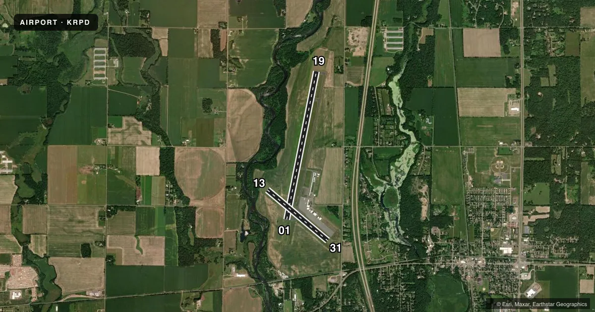
Runways & pattern
Full pagePattern entry · RWY 31
RIGHT TRAFFIC| Runway | Heading (°M) | Length | Surface | Traffic |
|---|---|---|---|---|
| 01/19 | 10° / 190° | 6,700 ft | ASPH | 01 R |
| 13/31Favored | 130° / 310° | 3,500 ft | ASPH | 31 R |
Runway end performance
| End | TORA | TODA | ASDA | LDA | VGSI | Approach lights | Obstruction |
|---|---|---|---|---|---|---|---|
| 01 | — | — | — | — | PAPI 2-box left(3°) | MALSR | 68', trees, 3300' from thr, 0' R of cntrln, slope 45 |
| 19 | — | — | — | — | PAPI 4-box left(3°) | — | — |
| 13 | — | — | — | — | PAPI 2-box left(3.75°) | — | 22', trees, 345' from thr, 130' R of cntrln, slope 6 |
| 31 | — | — | — | — | PAPI 2-box left(3.5°) | — | 72', trees, 1320' from thr, 210' R of cntrln, slope 15 |
Declared distances in feet. TORA = takeoff run available, TODA = takeoff distance, ASDA = accelerate-stop, LDA = landing distance.
Airport sketch
Runways drawn to scale from FAA survey coordinates, rendered over satellite imagery. Not for navigation.
Approaches & charts
ILS · 1
Services on the field
Fuel grades, oxygen, maintenance, ramp storage and lighting — as declared to the FAA by the airport operator.
Fuel & services
- Fuel
- 100LLA+
- Oxygen (bottled)
- High pressure
- Oxygen (bulk)
- High pressure
- Airframe repair
- Major
- Power plant repair
- Major
- Other services
- CHTR,INSTR,RNTL,SALES
Ramp & ground
- Transient storage
- Tie-down
- Hangar
- Lighting schedule
- SEE RMK
- Beacon schedule
- SS-SR
- Beacon
- White / Green (civil land)(WG)
- Wind indicator
- Lighted
- Segmented circle
- Yes
Fuel & FBOs
Cheapest 100LL and Jet A on the field and nearby. Always confirm with the FBO before taxi.
Airport notes
Surface conditions, obstructions, local procedures, lighting outages and other notes published with each FAA cycle.
General notes
- FOR CD IF UNA TO CTC ON FSS FREQ, CTC MINNEAPOLIS ARTCC AT 651-463-5588.
Lighting notes
- HIRL RY 01/19 PRESET ON LOW INTST SS-SR; TO INCR INTST & ACTVT REIL RY 19, PAPI RYS 01 & 19 & MALSR RY 01 - CTAF.
Fuel notes
- 100LL24 HR SELF SVC FUEL AVBL WITH CREDIT CARD.
Approach & departure obstructions
- 01APCH RATIO 50:1 TO DSPLCD THR.
Other notes
- PRVDD ALL TRAFFIC PATTERNSARE NORTH AND EAST DUE TO CONFLICT WITH BARRON MUNI; & TREES OFF RY 13 ARE RELOCATED OR REMOVED.
VFR map & nearby airports
VFR sectional. Tap any ICAO chip to open that airport.
Key facts · KRPD
Answer card- ICAO
- KRPD
- Name
- RICE LAKE RGNL/CARL'S FLD
- Location
- RICE LAKE, WISCONSIN
- Elevation
- 1,109.2 ft MSL
- Traffic pattern altitude
- 2,109.2 ft MSL (1,000 AGL)
- Control tower
- Non-towered (use CTAF)
- Total runways
- 2
- Longest runway
- 01/19 · 6,700 ft
- Published ILS approaches
- 1
- Published frequencies
- 2
- Magnetic variation
- 1°
- Current flight rules
- VFR
- Current wind
- 330° at 14 kt
- Favored runway now
- RWY 31
Rice Lake Rgnl/Carl's Fld sits in Rice Lake, Wisconsin. Field elevation is 1,109.2 ft MSL. The airport has two asphalt runways. The longest is 01/19 at 6,700 ft. Runway 13/31 is 3,500 ft. There is no control tower. Expect CTAF and UNICOM self-announce traffic on 122.7.
One ILS approach is published for runway 01. Pattern altitude is not published in the facts, so use the standard 1,000 ft AGL for light piston operations unless the current FAA Chart Supplement says otherwise. The field uses north and east traffic patterns because of conflict with Barron Municipal. That matters on a first visit. Runway 01 also has a displaced threshold note with a 50 to 1 approach ratio. Trees off runway 13 are noted as relocated or removed, so still verify the runway environment before landing.
Rice Lake Air Center is on the field. It carries 100LL and Jet A. Twenty-four hour self-serve 100LL is available with credit card. At night, runway 01/19 lighting comes up at low intensity by default. Use CTAF to increase intensity and to activate the runway end identifier lights, PAPI for 01 and 19 and the medium intensity approach lighting system with runway alignment indicator lights for runway 01. If you need clearance delivery help, the published remarks point pilots to Minneapolis ARTCC when FSS cannot be reached.