METAR & TAF 1H9
1H9 does not publish a METAR.
Showing the nearest reporting station: KHYR (SAWYER COUNTY) · 18.8 NM away. Conditions at 1H9 may differ.
METAR · KHYR
Observed 19:53Z
KHYR 271953Z AUTO 36010KT 10SM BKN020 OVC027 26/19 A2975 RMK AO2 SLP068 T02610194 $
- Wind
- 360° @ 10 kt
- Visibility
- 10 SM
- Temp / Dew
- 26°C / 19°C
- Altimeter
- 29.75 inHg
- Clouds
- OVC
- Density alt
- 2,913 ft
- Ceiling
- 2,000 ft AGL
- Rules
- MVFR
Airport info & contacts
Manager on record, flight service, ARTCC, attendance schedule and pattern altitude — published by the FAA and refreshed every 28 days.
Location
- From city
- 3 NM E
- VFR sectional
- GREEN BAY
- ARTCC
- ZMP · MINNEAPOLIS
- NOTAM facility
- GRB (NOTAM-D)
Airport manager
- Name
- KEITH JOHNSON
- Phone
- (847) 830-3064
- Address
- 5447 MADISON ST, MORTON GROVE IL 60053
Flight service · Hours
- FSS GRB
- GREEN BAY1-800-WX-BRIEF
- Attendance
- Unattended
Frequencies
Tap any row to copy the frequency to your clipboard.
Runways & pattern
Full pagePattern entry · RWY 01
LEFT TRAFFICRunway end performance
| End | TORA | TODA | ASDA | LDA | VGSI | Approach lights | Obstruction |
|---|---|---|---|---|---|---|---|
| 01 | — | — | — | — | — | — | 40', trees, 150' from thr, 110' R of cntrln, slope 3 |
| 19 | — | — | — | — | — | — | 50', trees, 801' from thr, 50' R of cntrln, slope 16 |
Declared distances in feet. TORA = takeoff run available, TODA = takeoff distance, ASDA = accelerate-stop, LDA = landing distance.
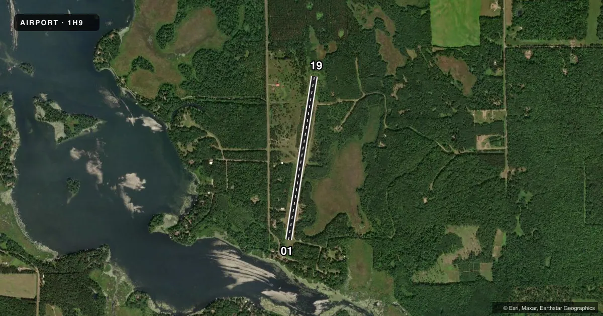
Airport sketch
Runways drawn to scale from FAA survey coordinates, rendered over satellite imagery. Not for navigation.
Approaches & charts
Services on the field
Fuel grades, oxygen, maintenance, ramp storage and lighting — as declared to the FAA by the airport operator.
Fuel & services
- Fuel
- Not available
Ramp & ground
- Transient storage
- Tie-down
- Landing fee
- No fee published
- Beacon schedule
- SS-SR
- Beacon
- White / Green (civil land)(WG)
- Wind indicator
- No
- Segmented circle
- No
Fuel & FBOs
Cheapest 100LL and Jet A on the field and nearby. Always confirm with the FBO before taxi.
Airport notes
Surface conditions, obstructions, local procedures, lighting outages and other notes published with each FAA cycle.
General notes
- WINTER MAINT NA.
- FOR CD CTC MINNEAPOLIS ARTCC AT 651-463-5588.
Approach & departure obstructions
- 01DTHR MKD WITH YELLOW CONES.
- 19DTHR MKD WITH YELLOW CONES.
- 01APCH RATIO 15:1 TO DTHR. 75 FT TREES 1125 FT FM DTHR ON CNTRLN.
Other notes
- PRVDD CLEAR 20:1 APCHS, CLEAR OBSTACLE FREE ZONE AND CLEAR RY SAFETY AREA.
VFR map & nearby airports
VFR sectional. Tap any ICAO chip to open that airport.
Key facts · 1H9
Answer card- ICAO
- 1H9
- Name
- NEST OF EAGLES
- Location
- SPOONER, WISCONSIN
- Elevation
- 1,115 ft MSL
- Traffic pattern altitude
- 2,115 ft MSL (1,000 AGL)
- Control tower
- Non-towered (use CTAF)
- Total runways
- 1
- Longest runway
- 01/19 · 3,600 ft
- Published ILS approaches
- 0
- Published frequencies
- 1
- Magnetic variation
- 2°
- Current flight rules
- MVFR
- Current wind
- 360° at 10 kt
- Favored runway now
- RWY 01
NEST OF EAGLES is in Spooner, Wisconsin. The field elevation is 1,115 ft MSL. It has one runway. Runway 01/19 is 3,600 ft of turf, so plan for soft-field technique and a careful look at braking and surface condition before you commit. There is no control tower. CTAF is 122.9.
No ILS approaches are published here. Pattern altitude is not published, so use the standard 1,000 ft AGL for light piston traffic unless the current FAA Chart Supplement says otherwise. The published remarks matter here. Displaced thresholds are marked with yellow cones on both ends. Winter maintenance is not available. There is also a published obstruction note for runway 01. Trees sit on the centerline beyond the displaced threshold, so pay close attention to the usable landing area and your approach path.
For clearance delivery, contact Minneapolis ARTCC at 651-463-5588. There are no on-field FBOs listed, so verify services with the airport operator or call ahead before you go. If you are planning a first stop into a turf field at this elevation, check the runway condition and current Chart Supplement before departure.