METAR & TAF KSSQ
KSSQ does not publish a METAR.
Showing the nearest reporting station: KUBE (CUMBERLAND MUNI) · 13.8 NM away. Conditions at KSSQ may differ.
METAR · KUBE
Observed 20:35Z
KUBE 272035Z AUTO 33012KT 10SM SCT020 OVC026 28/22 A2975 RMK AO2
- Wind
- 330° @ 12 kt
- Visibility
- 10 SM
- Temp / Dew
- 28°C / 22°C
- Altimeter
- 29.75 inHg
- Clouds
- OVC
- Density alt
- 3,300 ft
- Ceiling
- 2,600 ft AGL
- Rules
- MVFR
Airport info & contacts
Manager on record, flight service, ARTCC, attendance schedule and pattern altitude — published by the FAA and refreshed every 28 days.
Location
- From city
- 1 NM SE
- VFR sectional
- GREEN BAY
- ARTCC
- ZMP · MINNEAPOLIS
- NOTAM facility
- GRB (NOTAM-D)
Airport manager
- Name
- GERRY WINCH
- Phone
- (715) 296-3638
- Address
- 41 RIDGEWAY DR, P.O. BOX 520, SHELL LAKE WI 54871
Flight service · Hours
- FSS GRB
- GREEN BAY1-800-WX-BRIEF
- Attendance
- Unattended
Frequencies
Tap any row to copy the frequency to your clipboard.
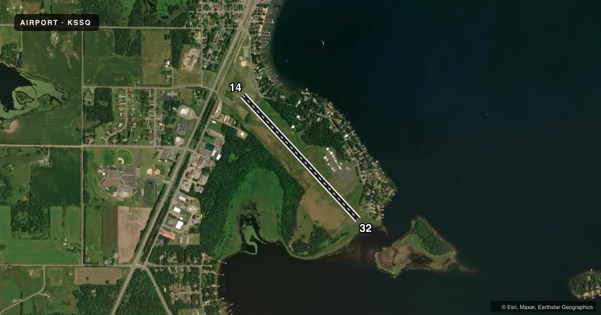
Runways & pattern
Full pagePattern entry · RWY 32
LEFT TRAFFICRunway end performance
| End | TORA | TODA | ASDA | LDA | VGSI | Approach lights | Obstruction |
|---|---|---|---|---|---|---|---|
| 14 | 3,711' | 3,711' | 3,500' | 2,881' | PAPI 2-box left(4°) | — | 95', trees, 1080' from thr, 400' R of cntrln, slope 9 |
| 32 | 3,286' | 3,711' | 3,711' | 3,500' | PAPI 2-box left(3°) | — | — |
Declared distances in feet. TORA = takeoff run available, TODA = takeoff distance, ASDA = accelerate-stop, LDA = landing distance.
Airport sketch
Runways drawn to scale from FAA survey coordinates, rendered over satellite imagery. Not for navigation.
Approaches & charts
Services on the field
Fuel grades, oxygen, maintenance, ramp storage and lighting — as declared to the FAA by the airport operator.
Fuel & services
- Fuel
- Not available
- Oxygen (bottled)
- Not available
- Oxygen (bulk)
- Not available
- Airframe repair
- Not available
- Power plant repair
- Not available
- Other services
- INSTR
Ramp & ground
- Transient storage
- Tie-down
- Hangar
- Landing fee
- No fee published
- Customs
- Not available
- Lighting schedule
- SEE RMK
- Beacon schedule
- SS-SR
- Beacon
- White / Green (civil land)(WG)
- Wind indicator
- Lighted
- Segmented circle
- Yes
Fuel & FBOs
Cheapest 100LL and Jet A on the field and nearby. Always confirm with the FBO before taxi.
Airport notes
Surface conditions, obstructions, local procedures, lighting outages and other notes published with each FAA cycle.
General notes
- (E81) TWY LGTS AT ENTRANCE ONLY.
- BIRDS ON & INVOF OF ARPT.
- FOR CD CTC MINNEAPOLIS ARTCC AT 651-463-5588.
Lighting notes
- MIRL RWY 14/32 PRESET TO LOW SS-SR; TO INCR INTST AND ACTVT REIL RWY 32; PAPI RWY 14, 32; MIRL RWY 14/32 - CTAF.
Approach & departure obstructions
- 14RWY 14 APCH RATIO 18:1 TO DSPLCD THLD; 93 FT TREES 1699 FT 400 L.
VFR map & nearby airports
VFR sectional. Tap any ICAO chip to open that airport.
Key facts · KSSQ
Answer card- ICAO
- KSSQ
- Name
- SHELL LAKE MUNI
- Location
- SHELL LAKE, WISCONSIN
- Elevation
- 1,233.3 ft MSL
- Traffic pattern altitude
- 2,233.3 ft MSL (1,000 AGL)
- Control tower
- Non-towered (use CTAF)
- Total runways
- 1
- Longest runway
- 14/32 · 3,711 ft
- Published ILS approaches
- 0
- Published frequencies
- 2
- Magnetic variation
- 1°
- Current flight rules
- MVFR
- Current wind
- 330° at 12 kt
- Favored runway now
- RWY 32
Shell Lake Muni is in Shell Lake, Wisconsin. The field elevation is 1,233.3 ft MSL. It has one runway. Runway 14/32 is 3,711 ft of asphalt, so plan performance with that length in mind. There is no control tower. CTAF and UNICOM are both 122.8.
No ILS approaches are published here. Pattern altitude is not published, so use the standard 1,000 ft AGL for light piston operations unless the current Chart Supplement says otherwise. That puts the traffic pattern at about 2,233 ft MSL based on the field elevation, but verify before you go.
The published remarks matter here. Runway lights on 14/32 are preset to low from sunset to sunrise. Use CTAF to increase intensity and to activate the runway end identifier lights for runway 32. Precision approach path indicators are installed on runways 14 and 32. Birds are reported on and near the airport, so keep a sharp scan on arrival and departure. Runway 14 also has an approach note tied to trees near the threshold. Taxiway lights are only at the entrance. No on-field FBOs are listed, so contact the airport operator directly before arrival if you need fuel or ramp details.