METAR & TAF KGTG
KGTG does not publish a METAR.
Showing the nearest reporting station: KRZN (BURNETT COUNTY) · 12.3 NM away. Conditions at KGTG may differ.
METAR · KRZN
Observed 21:55Z
KRZN 272155Z AUTO 03008KT 10SM CLR 28/20 A2979 RMK AO2 T02750196
- Wind
- 030° @ 8 kt
- Visibility
- 10 SM
- Temp / Dew
- 28°C / 20°C
- Altimeter
- 29.79 inHg
- Clouds
- CLR
- Density alt
- 2,871 ft
- Ceiling
- Unlimited
- Rules
- VFR
Airport info & contacts
Manager on record, flight service, ARTCC, attendance schedule and pattern altitude — published by the FAA and refreshed every 28 days.
Location
- From city
- 2 NM NE
- VFR sectional
- GREEN BAY
- ARTCC
- ZMP · MINNEAPOLIS
- NOTAM facility
- GRB (NOTAM-D)
Airport manager
- Name
- SHEILA MEYER
- Phone
- 715-463-2405
- Address
- 316 S. BRAD ST, GRANTSBURG WI 54840
Flight service · Hours
- FSS GRB
- GREEN BAY1-800-WX-BRIEF
- Attendance
- Unattended
Frequencies
Tap any row to copy the frequency to your clipboard.
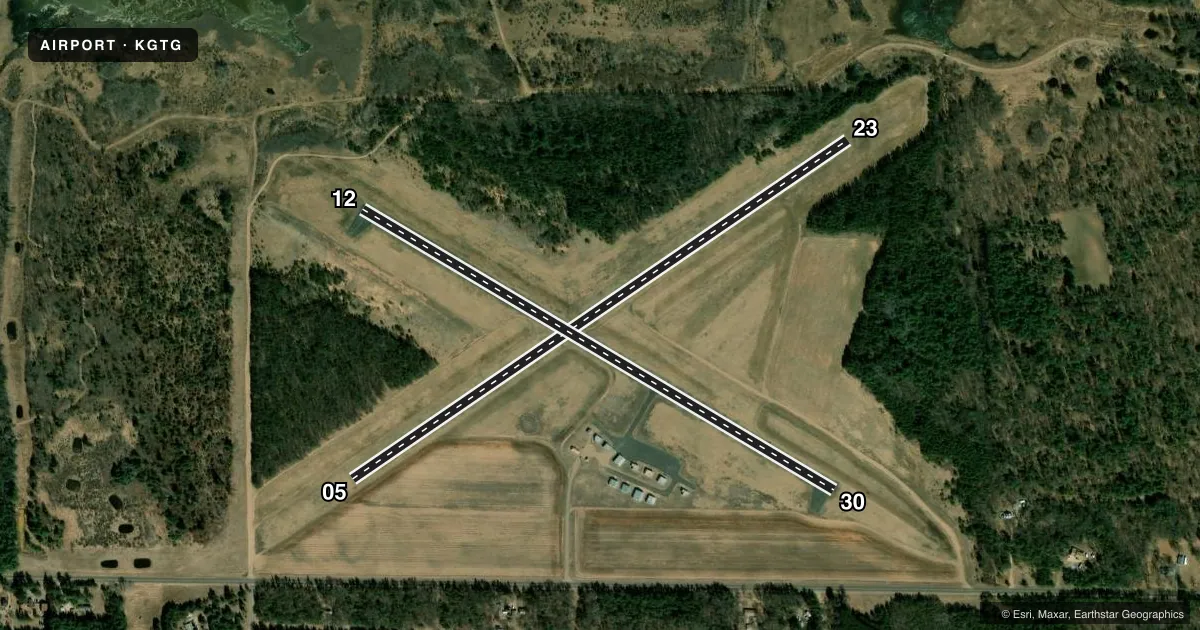
Runways & pattern
Full pagePattern entry · RWY 05
LEFT TRAFFIC| Runway | Heading (°M) | Length | Surface | Traffic |
|---|---|---|---|---|
| 05/23Favored | 56° / 236° | 3,280 ft | TURF | Standard L |
| 12/30 | 121° / 301° | 2,999 ft | ASPH | Standard L |
Runway end performance
| End | TORA | TODA | ASDA | LDA | VGSI | Approach lights | Obstruction |
|---|---|---|---|---|---|---|---|
| 23 | — | — | — | — | — | — | 30', trees, 225' from thr, 125' R of cntrln, slope 7 |
| 12 | — | — | — | — | — | — | 20', trees, 330' from thr, 225' R of cntrln, slope 6 |
| 30 | — | — | — | — | — | — | 50', trees, 700' from thr, 300' R of cntrln, slope 10 |
Declared distances in feet. TORA = takeoff run available, TODA = takeoff distance, ASDA = accelerate-stop, LDA = landing distance.
Airport sketch
Runways drawn to scale from FAA survey coordinates, rendered over satellite imagery. Not for navigation.
Approaches & charts
Services on the field
Fuel grades, oxygen, maintenance, ramp storage and lighting — as declared to the FAA by the airport operator.
Fuel & services
- Fuel
- Not available
- Oxygen (bottled)
- Not available
- Oxygen (bulk)
- Not available
Ramp & ground
- Transient storage
- Tie-down
- Landing fee
- No fee published
- Lighting schedule
- SEE RMK
- Beacon schedule
- SS-SR
- Beacon
- White / Green (civil land)(WG)
- Wind indicator
- Lighted
- Segmented circle
- Yes
Fuel & FBOs
Cheapest 100LL and Jet A on the field and nearby. Always confirm with the FBO before taxi.
Airport notes
Surface conditions, obstructions, local procedures, lighting outages and other notes published with each FAA cycle.
General notes
- DEER & WATERFOWL ON AND INVOF ARPT.
- 1100 FT MSL/182 FT AGL WATER TWR LCTD 5060 FT SW RWY 05.
- FOR CD CTC MINNEAPOLIS ARTCC AT 651-463-5588.
Lighting notes
- ACTVT MIRL RWY 12/30 - CTAF.
Runway surface & condition
- 05/23CLSD NOV 1 - APR 15.
Approach & departure obstructions
- 12MARKINGS FADED.
- 30MARKINGS FADED.
- 05RWY 05/23 MKD WITH YELLOW CONES.
Other notes
- EXISTED PRIOR TO 1959.
- MANAGEREMAIL ADDRESS: OFFICE@VILLAGEOFGRANTSBURG.GOV
- 12/30NUMEROUS CRACKS AND VEGETATION IN PAVEMENT.
VFR map & nearby airports
VFR sectional. Tap any ICAO chip to open that airport.
Key facts · KGTG
Answer card- ICAO
- KGTG
- Name
- GRANTSBURG MUNI
- Location
- GRANTSBURG, WISCONSIN
- Elevation
- 927.1 ft MSL
- Traffic pattern altitude
- 1,927.1 ft MSL (1,000 AGL)
- Control tower
- Non-towered (use CTAF)
- Total runways
- 2
- Longest runway
- 05/23 · 3,280 ft
- Published ILS approaches
- 0
- Published frequencies
- 1
- Magnetic variation
- 0°
- Current flight rules
- VFR
- Current wind
- 030° at 8 kt
- Favored runway now
- RWY 05
Grantsburg Muni sits in Grantsburg, Wisconsin at 927.1 ft MSL. It has two runways. The longest is runway 05/23 at 3,280 ft. The airport is not towered. CTAF is 122.9. No ILS approaches are published here. Pattern altitude is not published, so use the standard 1,000 ft AGL for light piston traffic unless the current Chart Supplement says otherwise.
Runway 05/23 is turf. It is marked with yellow cones. It is closed from November 1 through April 15. Runway 12/30 is asphalt at 2,999 ft. It has medium intensity runway lights that are activated on CTAF. The pavement has numerous cracks and some vegetation. Markings on runway 12 and runway 30 are faded, so a first-time arrival should plan for a careful visual check on rollout and taxi.
There are no on-field FBOs listed, so verify fuel and services with the airport operator or by calling the field before you go. Published remarks also note deer and waterfowl in the area. A water tower sits southwest of runway 05. Clearance delivery for IFR departures is handled through Minneapolis ARTCC at the published phone number. For a first trip in, review the current Chart Supplement for any operational updates before you launch.