METAR & TAF KROS
Current METAR
Observed 21:55Z
KROS 272155Z AUTO 36013G17KT 10SM CLR 28/22 A2977 RMK AO2 T02840220
- Wind
- 360° @ 13G17 kt
- Visibility
- 10 SM
- Temp / Dew
- 28°C / 22°C
- Altimeter
- 29.77 inHg
- Clouds
- CLR
- Density alt
- 2,895 ft
- Ceiling
- Unlimited
- Rules
- VFR
Airport info & contacts
Manager on record, flight service, ARTCC, attendance schedule and pattern altitude — published by the FAA and refreshed every 28 days.
Location
- From city
- 1 NM NE
- VFR sectional
- GREEN BAY
- ARTCC
- ZMP · MINNEAPOLIS
- NOTAM facility
- ROS (NOTAM-D)
Airport manager
- Name
- MARK NELSON
- Phone
- 612-554-7872
- Address
- 51601 FOREST BLVD, RUSH CITY MN 55069-2291
Flight service · Hours
- FSS PNM
- PRINCETON1-800-WX-BRIEF
- Attendance
- MON-FRI · 0700-1530
- SAT · 0900-1530
Frequencies
Tap any row to copy the frequency to your clipboard.
Runways & pattern
Full pagePattern entry · RWY 34
LEFT TRAFFICRunway end performance
| End | TORA | TODA | ASDA | LDA | VGSI | Approach lights | Obstruction |
|---|---|---|---|---|---|---|---|
| 16 | — | — | — | — | PAPI 4-box left(4°) | — | — |
| 34 | — | — | — | — | PAPI 4-box left(3°) | — | — |
Declared distances in feet. TORA = takeoff run available, TODA = takeoff distance, ASDA = accelerate-stop, LDA = landing distance.
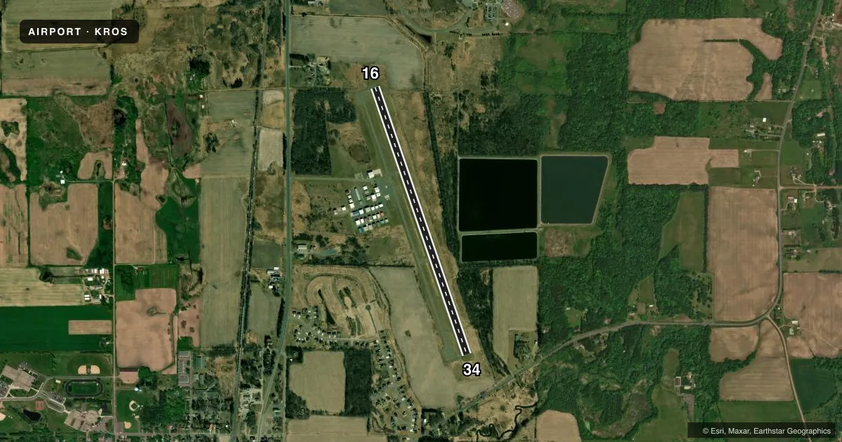
Airport sketch
Runways drawn to scale from FAA survey coordinates, rendered over satellite imagery. Not for navigation.
Approaches & charts
Services on the field
Fuel grades, oxygen, maintenance, ramp storage and lighting — as declared to the FAA by the airport operator.
Fuel & services
- Fuel
- 100LLA
- Oxygen (bottled)
- Not available
- Oxygen (bulk)
- Not available
- Airframe repair
- Not available
- Power plant repair
- Not available
- Other services
- INSTR,RNTL,SALES
Ramp & ground
- Transient storage
- Tie-down
- Hangar
- Landing fee
- No fee published
- Customs
- Not available
- Lighting schedule
- SEE RMK
- Beacon schedule
- SS-SR
- Beacon
- White / Green (civil land)(WG)
- Wind indicator
- Lighted
- Segmented circle
- No
Fuel & FBOs
Cheapest 100LL and Jet A on the field and nearby. Always confirm with the FBO before taxi.
Airport notes
Surface conditions, obstructions, local procedures, lighting outages and other notes published with each FAA cycle.
General notes
- GCO AVBL ON FREQ 121.725 THRU MINNEAPOLIS ARTCC & FLT SVCS.
- FOR TRANSIENT HANGAR CONTACT FBO OR ARPT MGR
- FOR CD IF UNA VIA GCO CTC MINNEAPOLIS ARTCC AT 651-463-5588.
Lighting notes
- ACTIVATE REIL RWY 16 & 34; PAPI RWY 16 & 34; MIRL RWY 16/34 PRESET TO LOW, INCR INTST AND ACTIVATE - CTAF
Fuel notes
- 100LLSELF SVC FUEL AVBL 24 HOURS WITH CREDIT CARD.
VFR map & nearby airports
VFR sectional. Tap any ICAO chip to open that airport.
Key facts · KROS
Answer card- ICAO
- KROS
- Name
- RUSH CITY RGNL
- Location
- RUSH CITY, MINNESOTA
- Elevation
- 926.4 ft MSL
- Traffic pattern altitude
- 1,926.4 ft MSL (1,000 AGL)
- Control tower
- Non-towered (use CTAF)
- Total runways
- 1
- Longest runway
- 16/34 · 4,401 ft
- Published ILS approaches
- 0
- Published frequencies
- 1
- Magnetic variation
- 2°
- Current flight rules
- VFR
- Current wind
- 360° at 13 kt
- Favored runway now
- RWY 34
Rush City Regional Airport sits in Rush City, Minnesota. Field elevation is 926.4 ft MSL. The airport has one runway. Runway 16/34 is 4,401 ft of asphalt, so plan around a shorter regional strip rather than a big metro field. There is no control tower. CTAF is 122.9.
No ILS approaches are published here. Pattern altitude is not published in the facts, so use the standard 1,000 ft AGL pattern unless the current Chart Supplement says otherwise. Runway lighting is pilot-controlled on CTAF. The published remarks say runway end identifier lights, PAPI for both ends and medium intensity runway lights are available on runway 16/34. The lights are preset to low. Self-serve 100LL is available 24 hours with credit card.
Rush City Regional Airport FBO is on the field. It carries AVGAS 100LL and JET A. Call (320) 358-4743 for current service details or transient hangar coordination. The remarks also note that clearance delivery can be handled through Minneapolis ARTCC if ground communications are not available. Ground communications outlet service is on 121.725 through Minneapolis ARTCC and flight services. For any current operating limits, hangar availability, or local procedures, check the current FAA Chart Supplement or call the airport operator before departure.