METAR & TAF KPNM
Current METAR
Observed 21:55Z
KPNM 272155Z AUTO 02012KT 10SM CLR 33/24 A2974 RMK AO2 T03330237
- Wind
- 020° @ 12 kt
- Visibility
- 10 SM
- Temp / Dew
- 33°C / 24°C
- Altimeter
- 29.74 inHg
- Clouds
- CLR
- Density alt
- 3,598 ft
- Ceiling
- Unlimited
- Rules
- VFR
Airport info & contacts
Manager on record, flight service, ARTCC, attendance schedule and pattern altitude — published by the FAA and refreshed every 28 days.
Location
- From city
- 1 NM SW
- VFR sectional
- TWIN CITIES
- ARTCC
- ZMP · MINNEAPOLIS
- NOTAM facility
- PNM (NOTAM-D)
Airport manager
- Name
- MICHELE MCPHERSON
- Phone
- 763-389-2040
- Address
- 705 N 2ND ST, PRINCETON MN 55371-1558
Flight service · Hours
- FSS PNM
- PRINCETON1-800-WX-BRIEF
- Attendance
- Unattended
Frequencies
Tap any row to copy the frequency to your clipboard.
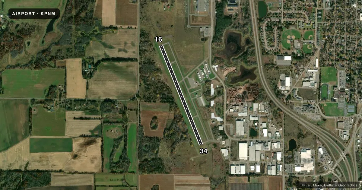
Runways & pattern
Full pagePattern entry · RWY 34
LEFT TRAFFICRunway end performance
| End | TORA | TODA | ASDA | LDA | VGSI | Approach lights | Obstruction |
|---|---|---|---|---|---|---|---|
| 16 | — | — | — | — | PAPI 4-box left(3°) | — | 19', tree, 379' from thr, 172' R of cntrln, slope 9 |
| 34 | — | — | — | — | PAPI 4-box right(3°) | — | — |
Declared distances in feet. TORA = takeoff run available, TODA = takeoff distance, ASDA = accelerate-stop, LDA = landing distance.
Airport sketch
Runways drawn to scale from FAA survey coordinates, rendered over satellite imagery. Not for navigation.
Approaches & charts
Services on the field
Fuel grades, oxygen, maintenance, ramp storage and lighting — as declared to the FAA by the airport operator.
Fuel & services
- Fuel
- 100LL
- Oxygen (bottled)
- Not available
- Oxygen (bulk)
- Not available
- Airframe repair
- Not available
- Power plant repair
- Not available
- Other services
- RNTL,SALES,SURV
Ramp & ground
- Transient storage
- Tie-down
- Landing fee
- No fee published
- Customs
- Not available
- Lighting schedule
- SEE RMK
- Beacon schedule
- SS-SR
- Beacon
- White / Green (civil land)(WG)
- Wind indicator
- Lighted
- Segmented circle
- No
Fuel & FBOs
Cheapest 100LL and Jet A on the field and nearby. Always confirm with the FBO before taxi.
Airport notes
Surface conditions, obstructions, local procedures, lighting outages and other notes published with each FAA cycle.
General notes
- OCNL HEL OPS INVOF ARPT; LGTD HOSP HELI 1 NM ESE.
- ULTRALIGHTS ON & INVOF ARPT.
- FOR CD IF UNA TO CTC ON FSS FREQ, CTC MINNEAPOLIS ARTCC AT 651-463-5588.
Lighting notes
- ACTVT REIL RWY 16 & 34; PAPI RWY 16 & 34; MIRL RWY 16/34 - CTAF.
Fuel notes
- 100LLFUEL AVBL H24 WITH CREDIT CARD.
Approach & departure obstructions
- 16PAPI UNUSBL BYD 6 DEGS LEFT OF CNTRLN.
VFR map & nearby airports
VFR sectional. Tap any ICAO chip to open that airport.
Key facts · KPNM
Answer card- ICAO
- KPNM
- Name
- PRINCETON MUNI
- Location
- PRINCETON, MINNESOTA
- Elevation
- 979.8 ft MSL
- Traffic pattern altitude
- 1,979.8 ft MSL (1,000 AGL)
- Control tower
- Non-towered (use CTAF)
- Total runways
- 1
- Longest runway
- 16/34 · 3,900 ft
- Published ILS approaches
- 0
- Published frequencies
- 2
- Magnetic variation
- 3°
- Current flight rules
- VFR
- Current wind
- 020° at 12 kt
- Favored runway now
- RWY 34
Princeton Muni is in Princeton, Minnesota. The field elevation is 979.8 ft MSL. It has one runway, 16/34, which is 3,900 ft long and paved with asphalt. There is no control tower. CTAF and UNICOM are both 123.0. No ILS approaches are published here.
Pattern altitude is not published. For light piston work, use the standard 1,000 ft AGL unless current local guidance says otherwise. Runway 16/34 has medium intensity lighting on the common traffic advisory frequency. Runway end identifier lights and PAPI are installed on both ends. The PAPI on runway 16 is unusable more than 6 degrees left of centerline, so keep that in mind on final.
Princeton Municipal Airport is the on-field FBO. It carries 100LL. Fuel is available 24 hours a day with a credit card. Ultralights operate on and near the airport. Helicopter traffic also shows up in the area. A lighted hospital helicopter is located 1 NM east-southeast, so stay alert in the pattern and on departure. If you need clearance delivery and cannot reach Flight Service, Minneapolis ARTCC is listed as the backup contact. Check the current FAA Chart Supplement for any changes before you go.