METAR & TAF KCBG
Current METAR
Observed 18:35Z
KCBG 271835Z AUTO 33010G17KT 10SM CLR 34/23 A2972 RMK AO2 T03380226 $
- Wind
- 330° @ 10G17 kt
- Visibility
- 10 SM
- Temp / Dew
- 34°C / 23°C
- Altimeter
- 29.72 inHg
- Clouds
- CLR
- Density alt
- 3,700 ft
- Ceiling
- Unlimited
- Rules
- VFR
Airport info & contacts
Manager on record, flight service, ARTCC, attendance schedule and pattern altitude — published by the FAA and refreshed every 28 days.
Location
- From city
- 2 NM SW
- VFR sectional
- TWIN CITIES
- ARTCC
- ZMP · MINNEAPOLIS
- NOTAM facility
- CBG (NOTAM-D)
Airport manager
- Name
- LUCAS MILZ
- Phone
- 763-552-3279
- Address
- CITY OF CAMBRIDGE, 300 3RD AVE NE, CAMBRIDGE MN 55008-9013
Flight service · Hours
- FSS PNM
- PRINCETON1-800-WX-BRIEF
- Attendance
- Unattended
Frequencies
Tap any row to copy the frequency to your clipboard.
Runways & pattern
Full pagePattern entry · RWY 34
LEFT TRAFFICRunway end performance
| End | TORA | TODA | ASDA | LDA | VGSI | Approach lights | Obstruction |
|---|---|---|---|---|---|---|---|
| 16 | — | — | — | — | PAPI 4-box right(3°) | — | — |
| 34 | — | — | — | — | PAPI 4-box left(3°) | — | 61', trees, 1264' from thr, 384' R of cntrln, slope 17 |
Declared distances in feet. TORA = takeoff run available, TODA = takeoff distance, ASDA = accelerate-stop, LDA = landing distance.
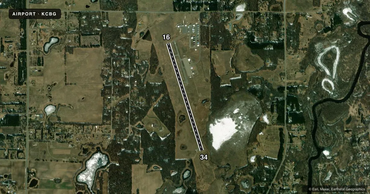
Airport sketch
Runways drawn to scale from FAA survey coordinates, rendered over satellite imagery. Not for navigation.
Approaches & charts
Services on the field
Fuel grades, oxygen, maintenance, ramp storage and lighting — as declared to the FAA by the airport operator.
Fuel & services
- Fuel
- 100LLA
- Oxygen (bottled)
- Not available
- Oxygen (bulk)
- Not available
- Airframe repair
- Not available
- Power plant repair
- Not available
- Other services
- INSTR,RNTL,SALES,SURV
Ramp & ground
- Transient storage
- Tie-down
- Hangar
- Landing fee
- No fee published
- Customs
- Not available
- Lighting schedule
- SEE RMK
- Beacon schedule
- SS-SR
- Beacon
- White / Green (civil land)(WG)
- Wind indicator
- Lighted
- Segmented circle
- No
Fuel & FBOs
Cheapest 100LL and Jet A on the field and nearby. Always confirm with the FBO before taxi.
Airport notes
Surface conditions, obstructions, local procedures, lighting outages and other notes published with each FAA cycle.
General notes
- MIGRATORY WATERFOWL & DEER ON & INVOF ARPT.
- FOR NOISE ABATEMENT RWY 16 DEPS FLY RWY HDG TO 1945 FT MSL (1000 FT AGL) & 2 NM BFR LEFT TURN.
- CODE FOR AD BLDG: LAST 3 DIGITS OF EMERG FREQ.
- FOR CD CTC MINNEAPOLIS ARTCC AT 651-463-5588.
Lighting notes
- ACTVT OR INCR INTST REIL RWY 34; PAPI RWY 16 & 34; MIRL RWY 16/34 - CTAF. MIRL RWY 16/34 PRESET LOW INTST SS-SR.
Fuel notes
- 100LLFUEL AVBL H24 SELF SER VIA CREDIT CARD.
Other notes
- MANAGERCELL 612-221-9878.
VFR map & nearby airports
VFR sectional. Tap any ICAO chip to open that airport.
Key facts · KCBG
Answer card- ICAO
- KCBG
- Name
- CAMBRIDGE MUNI
- Location
- CAMBRIDGE, MINNESOTA
- Elevation
- 945.4 ft MSL
- Traffic pattern altitude
- 1,945.4 ft MSL (1,000 AGL)
- Control tower
- Non-towered (use CTAF)
- Total runways
- 1
- Longest runway
- 16/34 · 4,001 ft
- Published ILS approaches
- 0
- Published frequencies
- 2
- Magnetic variation
- 1°
- Current flight rules
- VFR
- Current wind
- 330° at 10 kt
- Favored runway now
- RWY 34
Cambridge Muni sits in Cambridge, Minnesota. The field elevation is 945.4 ft MSL. It has one runway. Runway 16/34 is 4,001 ft long, so plan performance with that length in mind. There is no control tower. CTAF and UNICOM are both 122.8.
No ILS approaches are published here. Pattern altitude is not published in the facts, so use the current FAA Chart Supplement before you fly. The airport has one on-field FBO listed as Cambridge Municipal Airport. It carries AVGAS 100LL. Fuel is available 24 hours a day self-service via credit card.
For runway 16 departures, the published noise abatement asks you to fly runway heading to 1,945 ft MSL. That is 1,000 ft AGL. Keep going straight for 2 NM before turning left. Runway 34 has REILs. Both runways have PAPI. Medium intensity runway lights are on both runways. They are controlled on CTAF. They are preset to low intensity from sunset to sunrise. Expect wildlife on and near the airport. Deer and migratory waterfowl are specifically noted. If you need clearance delivery, contact Minneapolis ARTCC. For any current operating detail that is not listed here, check the current FAA Chart Supplement or call the airport operator or FBO directly.