METAR & TAF KANE
Current METAR
Observed 14:45Z
KANE 131445Z 31015G18KT 10SM CLR 21/08 A2986
- Wind
- 310° @ 15G18 kt
- Visibility
- 10 SM
- Temp / Dew
- 21°C / 8°C
- Altimeter
- 29.86 inHg
- Clouds
- CLR
- Density alt
- 1,926 ft
- Ceiling
- Unlimited
- Rules
- VFR
Airport info & contacts
Manager on record, flight service, ARTCC, attendance schedule and pattern altitude — published by the FAA and refreshed every 28 days.
Location
- From city
- 10 NM N
- VFR sectional
- TWIN CITIES
- ARTCC
- ZMP · MINNEAPOLIS
- NOTAM facility
- ANE (NOTAM-D)
Airport manager
- Name
- PHILIP TIEDEMAN
- Phone
- 763-717-0001
- Address
- 881 AIRPORT ROAD, BOX C1, MINNEAPOLIS MN 55449-2701
Flight service · Hours
- FSS PNM
- PRINCETON1-800-WX-BRIEF
- Attendance
- ALL
Frequencies
Tap any row to copy the frequency to your clipboard.
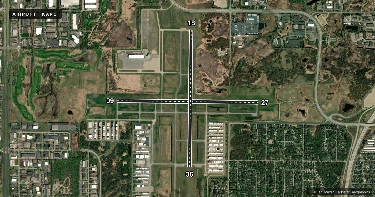
Runways & pattern
Full pagePattern entry · RWY 27
RIGHT TRAFFIC| Runway | Heading (°M) | Length | Surface | Traffic |
|---|---|---|---|---|
| 09/27Favored | 89° / 269° | 5,000 ft | ASPH | 27 R |
| 18/36 | 179° / 359° | 4,855 ft | ASPH | 18 R |
Runway end performance
| End | TORA | TODA | ASDA | LDA | VGSI | Approach lights | Obstruction |
|---|---|---|---|---|---|---|---|
| 09 | — | — | — | — | PAPI 4-box left(3°) | — | — |
| 27 | — | — | — | — | PAPI 4-box left(3°) | MALSR | — |
| 18 | — | — | — | — | VASI 4-box left(3°) | — | — |
| 36 | — | — | — | — | VASI 4-box left(3°) | — | — |
Declared distances in feet. TORA = takeoff run available, TODA = takeoff distance, ASDA = accelerate-stop, LDA = landing distance.
Airport sketch
Runways drawn to scale from FAA survey coordinates, rendered over satellite imagery. Not for navigation.
Approaches & charts
ILS · 1
Services on the field
Fuel grades, oxygen, maintenance, ramp storage and lighting — as declared to the FAA by the airport operator.
Fuel & services
- Fuel
- 100LLA
- Oxygen (bottled)
- HIGH/LOW
- Oxygen (bulk)
- Not available
- Airframe repair
- Major
- Power plant repair
- Major
- Other services
- AFRT,AMB,AVNCS,CHTR,INSTR,RNTL,SALES,SURV
Ramp & ground
- Transient storage
- Tie-down
- Hangar
- Landing fee
- Yes
- Customs
- Not available
- Lighting schedule
- SEE RMK
- Beacon schedule
- SS-SR
- Beacon
- White / Green (civil land)(WG)
- Wind indicator
- Lighted
- Segmented circle
- No
Fuel & FBOs
Cheapest 100LL and Jet A on the field and nearby. Always confirm with the FBO before taxi.
Airport notes
Surface conditions, obstructions, local procedures, lighting outages and other notes published with each FAA cycle.
General notes
- DEER, BIRDS, & WILDLIFE ON & INVOF ARPT.
- VOLUNTARY NOISE ABATEMENT PROCS IN EFCT. SEE ARPT WEBSITE FOR MORE INFO.
- WHEN ATCT IS CLSD SNOW REMOVAL OPRS MNT CTAF.
- WHEN ATCT CLSD, FOR CD CTC MINNEAPOLIS APCH ON 121.85.
Lighting notes
- ACTVT OR INCR INTST MALSR RWY 27; REIL RWY 09, 18, & 36; PAPI RWY 09 & 27; VASI RWY 18 & 36; HIRL RWY 09/27; MIRL RWY 18/36 - CTAF. HIRL RWY 09/27 & MIRL RWY 18/36 PRESET LOW INTST.
Fuel notes
- 100LL100LL AVBL H24 VIA CREDIT CARD AT LYNX SOUTH RAMP.
- AJET A AVBL AT FBOS SUBJ LDG FEE CTC FBO.
Approach & departure obstructions
- 27CALM WIND RWY WHEN ATCT IS CLSD.
Other notes
- LDG FEE FOR TURBINE ACFT.
- FOR HNGR STORAGE CTC FBO.
- MANAGERPHILIP.TIEDEMAN@MSPMAC.ORG.
VFR map & nearby airports
VFR sectional. Tap any ICAO chip to open that airport.
Key facts · KANE
Answer card- ICAO
- KANE
- Name
- ANOKA COUNTY/BLAINE (JANES FLD)
- Location
- MINNEAPOLIS, MINNESOTA
- Elevation
- 912.2 ft MSL
- Traffic pattern altitude
- 1,912.2 ft MSL (1,000 AGL)
- Control tower
- Towered · 0700-2100 OCT-APR; 0700-2200 MAY-SEP
- Total runways
- 2
- Longest runway
- 09/27 · 5,000 ft
- Published ILS approaches
- 1
- Published frequencies
- 10
- Magnetic variation
- 2°
- Current flight rules
- VFR
- Current wind
- 310° at 15 kt
- Favored runway now
- RWY 27
KANE is Anoka County/Blaine (Janes Fld) in Minneapolis, Minnesota. Field elevation is 912.2 ft MSL. The airport has two asphalt runways. The longest is 5,000 ft on 09/27. Runway 18/36 is 4,855 ft. The tower is open 0700-2100 OCT-APR. It is open 0700-2200 MAY-SEP. One ILS is published for runway 27. Pattern altitude is not published, so use the standard 1,000 ft AGL for light piston traffic unless ATC or the Chart Supplement says otherwise.
Atlantic Aviation is the on-field FBO. It carries 100LL, Jet A and Jet A Prist. 100LL is also listed as available 24 hours a day via credit card at Lynx South Ramp. Jet A is available at FBOs subject to a landing fee. The field has voluntary noise abatement procedures. Check the airport website or the current FAA Chart Supplement before you go if you need the details. Deer, birds and other wildlife are reported on and near the airport, so keep a sharp scan on taxi, takeoff and landing. When the tower is closed, runway 27 is the calm wind runway. The lighting setup is active on multiple runway ends, so brief your arrival and taxi carefully. Monitor CTAF.