METAR & TAF 25D
25D does not publish a METAR.
Showing the nearest reporting station: KANE (ANOKA COUNTY/BLAINE (JANES FLD)) · 11.1 NM away. Conditions at 25D may differ.
METAR · KANE
Observed 15:50Z
KANE 271550Z 32010KT 10SM CLR 32/22 A2969
- Wind
- 320° @ 10 kt
- Visibility
- 10 SM
- Temp / Dew
- 32°C / 22°C
- Altimeter
- 29.69 inHg
- Clouds
- CLR
- Density alt
- 3,478 ft
- Ceiling
- Unlimited
- Rules
- VFR
Airport info & contacts
Manager on record, flight service, ARTCC, attendance schedule and pattern altitude — published by the FAA and refreshed every 28 days.
Location
- From city
- 2 NM SW
- VFR sectional
- GREEN BAY
- ARTCC
- ZMP · MINNEAPOLIS
- NOTAM facility
- PNM (NOTAM-D)
Airport manager
- Name
- PATRICK CASEY
- Phone
- 651-209-9750
- Address
- 1408 LAKE STREET SOUTH, FOREST LAKE MN 55025
Flight service · Hours
- FSS PNM
- PRINCETON1-800-WX-BRIEF
- Attendance
- Unattended
Frequencies
Tap any row to copy the frequency to your clipboard.
Runways & pattern
Full pagePattern entry · RWY 31
LEFT TRAFFICRunway end performance
| End | TORA | TODA | ASDA | LDA | VGSI | Approach lights | Obstruction |
|---|---|---|---|---|---|---|---|
| 13 | — | — | — | — | PAPI 4-box left(3.5°) | — | — |
| 31 | — | — | — | — | PAPI 4-box left(3.5°) | — | — |
Declared distances in feet. TORA = takeoff run available, TODA = takeoff distance, ASDA = accelerate-stop, LDA = landing distance.
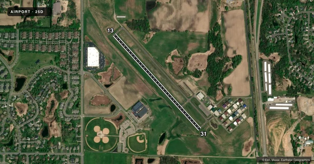
Airport sketch
Runways drawn to scale from FAA survey coordinates, rendered over satellite imagery. Not for navigation.
Approaches & charts
Services on the field
Fuel grades, oxygen, maintenance, ramp storage and lighting — as declared to the FAA by the airport operator.
Fuel & services
- Fuel
- 100LL
- Oxygen (bottled)
- Not available
- Oxygen (bulk)
- Not available
- Airframe repair
- Not available
- Power plant repair
- Not available
- Other services
- SALES
Ramp & ground
- Transient storage
- Tie-down
- Landing fee
- No fee published
- Customs
- Not available
- Lighting schedule
- SEE RMK
- Beacon schedule
- SS-SR
- Beacon
- White / Green (civil land)(WG)
- Wind indicator
- Yes
- Segmented circle
- No
Fuel & FBOs
Cheapest 100LL and Jet A on the field and nearby. Always confirm with the FBO before taxi.
Airport notes
Surface conditions, obstructions, local procedures, lighting outages and other notes published with each FAA cycle.
General notes
- CALM WIND RY 13.
- FOR CD CTC MINNEAPOLIS APCH AT 612-713-4016.
Lighting notes
- MIRL RY 13/31 PRESET TO LOW SS-SR; TO INCR INTST & ACTVT PAPI & REIL RY 13 & 31 - CTAF.
Fuel notes
- 100LLFUEL AVBL 24 HRS SELF SERVICE WITH CREDIT CARD.
Runway surface & condition
- 13/31STEEP DROP IN TERRAIN ALONG NORTHEAST SIDE OF RY.
Approach & departure obstructions
- 31RWY 31 HAS 5 FT BRUSH 105 FT FROM THE RWY END AND 84 FT L.
Other notes
- PRVDD RAMP IS RELCTD OUTSIDE OF THE APCH SLOPE TO RWY 13.
- MANAGEREMAIL ADDRESS: DAN.UNDEM@CI.FOREST-LAKE.MN.US (ALL LOWER CASE).
VFR map & nearby airports
VFR sectional. Tap any ICAO chip to open that airport.
Key facts · 25D
Answer card- ICAO
- 25D
- Name
- FOREST LAKE
- Location
- FOREST LAKE, MINNESOTA
- Elevation
- 929.5 ft MSL
- Traffic pattern altitude
- 1,929.5 ft MSL (1,000 AGL)
- Control tower
- Non-towered (use CTAF)
- Total runways
- 1
- Longest runway
- 13/31 · 2,700 ft
- Published ILS approaches
- 0
- Published frequencies
- 2
- Magnetic variation
- 3°
- Current flight rules
- VFR
- Current wind
- 320° at 10 kt
- Favored runway now
- RWY 31
Forest Lake Airport sits in Forest Lake, Minnesota. The field elevation is 929.5 ft MSL. It has one runway, 13/31, at 2,700 ft of asphalt. This is a non-towered field. CTAF and UNICOM are both 122.7. No ILS approaches are published here.
Pattern altitude is not published. Use 1,000 ft AGL as the standard light-piston pattern unless the current Chart Supplement or local guidance says otherwise. The published remarks matter here. Runway 31 has brush near the departure end. There is also a steep drop in terrain along the northeast side of the runway. The ramp has been relocated outside the approach slope to runway 13. That is worth keeping in mind on arrival and departure.
Forest Lake Airport has one on-field FBO. Forest Lake Airport carries AVGAS 100LL. Self-serve fuel is available 24 hours with credit card. For clearance delivery, the published contact is Minneapolis Approach. If you are planning a night arrival, the runway lights are preset low from sunset to sunrise. Use CTAF to increase intensity and to activate PAPI and REIL for runways 13 and 31. Calm wind favors runway 13. Check the current Chart Supplement for any additional local notes before you go.