METAR & TAF KOEO
Current METAR
Observed 17:15Z
KOEO 271715Z AUTO 32007KT 270V340 10SM CLR 33/27 A2973 RMK AO2 T03300274
- Wind
- 320° @ 7 kt
- Visibility
- 10 SM
- Temp / Dew
- 33°C / 27°C
- Altimeter
- 29.73 inHg
- Clouds
- CLR
- Density alt
- 3,519 ft
- Ceiling
- Unlimited
- Rules
- VFR
Airport info & contacts
Manager on record, flight service, ARTCC, attendance schedule and pattern altitude — published by the FAA and refreshed every 28 days.
Location
- From city
- 0 NM SE
- VFR sectional
- GREEN BAY
- ARTCC
- ZMP · MINNEAPOLIS
- NOTAM facility
- OEO (NOTAM-D)
Airport manager
- Name
- RICHARD JOHNSON
- Phone
- 715-294-4500
- Address
- PO BOX 643, OSCEOLA WI 54020
Flight service · Hours
- FSS GRB
- GREEN BAY1-800-WX-BRIEF
- Attendance
- MON-FRI · 0900-1600
Frequencies
Tap any row to copy the frequency to your clipboard.
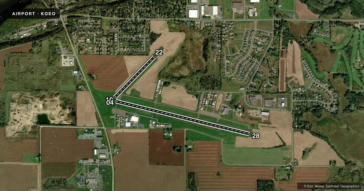
Runways & pattern
Full pagePattern entry · RWY 28
LEFT TRAFFIC| Runway | Heading (°M) | Length | Surface | Traffic |
|---|---|---|---|---|
| 10/28Favored | 103° / 283° | 5,006 ft | ASPH | Standard L |
| 04/22 | 44° / 224° | 2,065 ft | TURF | Standard L |
Runway end performance
| End | TORA | TODA | ASDA | LDA | VGSI | Approach lights | Obstruction |
|---|---|---|---|---|---|---|---|
| 10 | — | — | — | — | PAPI 2-box left(3°) | — | 15', road, 500' from thr, 540' R of cntrln, slope 20 |
| 28 | — | — | — | — | PAPI 4-box left(3°) | — | — |
Declared distances in feet. TORA = takeoff run available, TODA = takeoff distance, ASDA = accelerate-stop, LDA = landing distance.
Airport sketch
Runways drawn to scale from FAA survey coordinates, rendered over satellite imagery. Not for navigation.
Approaches & charts
Services on the field
Fuel grades, oxygen, maintenance, ramp storage and lighting — as declared to the FAA by the airport operator.
Fuel & services
- Fuel
- 100LLA+
- Airframe repair
- Major
- Power plant repair
- Major
- Other services
- INSTR,RNTL
Ramp & ground
- Transient storage
- Tie-down
- Landing fee
- No fee published
- Customs
- Not available
- Lighting schedule
- SEE RMK
- Beacon schedule
- SS-SR
- Beacon
- White / Green (civil land)(WG)
- Wind indicator
- Lighted
- Segmented circle
- Yes
Fuel & FBOs
Cheapest 100LL and Jet A on the field and nearby. Always confirm with the FBO before taxi.
Airport notes
Surface conditions, obstructions, local procedures, lighting outages and other notes published with each FAA cycle.
General notes
- RWY 04/22 CLSD TO WHEELED ACFT WHEN COVERED WITH SNOW OR ICE; OPEN TO SKI EQUIPPED ACFT WINTER MONTHS. CTC AMGR 612-308-0647.
- GCO AVBL ON FREQ 121.725 MSP CD & FLT SVCS.
- AVOID OVERFLIGHT OF ST CROIX RIVER NATIONAL SCENIC BI-WAY BLW 2000 FT AGL EXC ON TAKEOFF OR LDG.
- GLIDER & ULTRALIGHT ACTIVITY ON & INVOF ARPT.
- DEER & BIRDS ON & INVOF ARPT.
- FOR CD CTC MINNEAPOLIS APCH AT 612-713-4016.
Lighting notes
- MIRL RWY 10/28 PRESET TO LOW SS-SR; TO INCR INTST AND ACTVT REIL RWY 28; PAPI RWY 10 & 28 - CTAF.
Fuel notes
- 100LLSELF SVC FUEL AVBL 24 HRS.
Approach & departure obstructions
- 04MKD WITH YELLOW CONES.
- 22MKD WITH YELLOW CONES.
Other notes
- MANAGEREMAIL ADDRESS: RJOHNSON@OSCEOLAAERO.COM (ALL LOWER CASE)
VFR map & nearby airports
VFR sectional. Tap any ICAO chip to open that airport.
Key facts · KOEO
Answer card- ICAO
- KOEO
- Name
- L O SIMENSTAD MUNI
- Location
- OSCEOLA, WISCONSIN
- Elevation
- 905.6 ft MSL
- Traffic pattern altitude
- 1,905.6 ft MSL (1,000 AGL)
- Control tower
- Non-towered (use CTAF)
- Total runways
- 2
- Longest runway
- 10/28 · 5,006 ft
- Published ILS approaches
- 0
- Published frequencies
- 3
- Magnetic variation
- 1°
- Current flight rules
- VFR
- Current wind
- 320° at 7 kt
- Favored runway now
- RWY 28
L O Simenstad Muni sits in Osceola, Wisconsin. Field elevation is 905.6 ft MSL. The airport has two runways. The longest is 10/28 at 5,006 ft. It is the runway most pilots will plan around for normal arrivals and departures. There is no control tower. CTAF is 122.9. No ILS approaches are published here, so check the current Chart Supplement and your approach setup before you go.
Pattern altitude is not published in the facts. Use the standard 1,000 ft AGL pattern unless the current Chart Supplement says otherwise. Osceola AeroSport is on the field. It carries 100LL and Jet A with Prist available. Self-service fuel is available 24 hours. Runway 10/28 has medium intensity lights that come up low from sunset to sunrise. Use CTAF to raise intensity and to activate the runway end identifier lights on runway 28. PAPI is installed on runways 10 and 28.
A few local items matter here. Runway 04 and runway 22 are marked with yellow cones. Runway 04/22 is closed to wheeled aircraft when covered with snow or ice. Glider and ultralight activity also occurs on and near the airport. Avoid overflying the St Croix River National Scenic Byway below 2,000 ft AGL except on takeoff or landing. Deer and birds are reported on and near the field.