METAR & TAF 8Y4
8Y4 does not publish a METAR.
Showing the nearest reporting station: KANE (ANOKA COUNTY/BLAINE (JANES FLD)) · 3.7 NM away. Conditions at 8Y4 may differ.
METAR · KANE
Observed 20:45Z
KANE 242045Z 19015KT 10SM OVC043 27/17 A2995
- Wind
- 190° @ 15 kt
- Visibility
- 10 SM
- Temp / Dew
- 27°C / 17°C
- Altimeter
- 29.95 inHg
- Clouds
- OVC
- Density alt
- 2,494 ft
- Ceiling
- 4,300 ft AGL
- Rules
- VFR
Airport info & contacts
Manager on record, flight service, ARTCC, attendance schedule and pattern altitude — published by the FAA and refreshed every 28 days.
Location
- From city
- 2 NM S
- VFR sectional
- TWIN CITIES
- ARTCC
- ZMP · MINNEAPOLIS
- NOTAM facility
- PNM (NOTAM-D)
Airport manager
- Name
- DAN KEDROWSKI
- Phone
- 612-309-3189
- Address
- 14315 URAL ST NE, HAM LAKE MN 55304-6628
Flight service · Hours
- FSS PNM
- PRINCETON1-800-WX-BRIEF
- Attendance
- MAY-OCT · DAWN-DUSK
- NOV-APR · Unattended
Frequencies
Tap any row to copy the frequency to your clipboard.
Runways & pattern
Full pageRunway & wind
tap a runwayPattern entry · RWY 23W
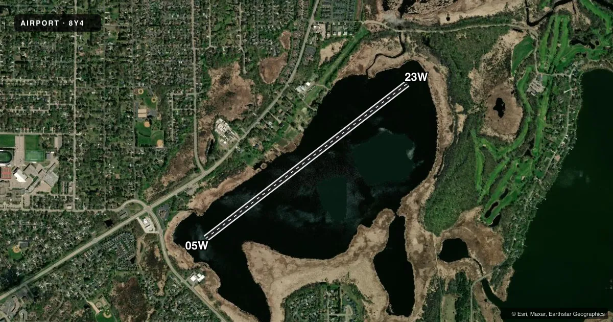
LEFT TRAFFICAirport sketch
Runways drawn to scale from FAA survey coordinates, rendered over satellite imagery. Not for navigation.
Approaches & charts
Services on the field
Fuel grades, oxygen, maintenance, ramp storage and lighting — as declared to the FAA by the airport operator.
Fuel & services
- Fuel
- 100LL
- Airframe repair
- Major
- Power plant repair
- Major
- Other services
- BCHGR,INSTR,RNTL,SALES
Ramp & ground
- Transient storage
- Tie-down
- Landing fee
- No fee published
- Customs
- Not available
- Wind indicator
- Yes
- Segmented circle
- No
Fuel & FBOs
Cheapest 100LL and Jet A on the field and nearby. Always confirm with the FBO before taxi.
Airport notes
Surface conditions, obstructions, local procedures, lighting outages and other notes published with each FAA cycle.
General notes
- PLAN APCH OVER MARSHAN OR BALDWIN LAKES.
- 500' TWR 2 MI EAST RIGHT OF DEP PATH.
- SOUTH DEPS MAKE LEFT TURNOUT.
- FOR CD CTC MINNEAPOLIS APCH AT 612-713-4016.
- EXCESSIVE WEEDS & AQUATIC INVASIVE PLANTS IN RICE LAKE.
Fuel notes
- 100LLFOR SVC AFT HRS: 612-309-3189.
Other notes
- MANAGERALT CTC: DANKEDROWSKI@GMAIL.COM OR BOBTIMM@SEAPLANESERVICES.COM.
- MANAGERALT CTC: BOB TIMM 612-518-0687.
- 05W/23WEXCESSIVE WEEDS.
VFR map & nearby airports
VFR sectional. Tap any ICAO chip to open that airport.
Key facts · 8Y4
Answer card- ICAO
- 8Y4
- Name
- SURFSIDE
- Location
- LINO LAKES, MINNESOTA
- Elevation
- 880 ft MSL
- Traffic pattern altitude
- 1,880 ft MSL (1,000 AGL)
- Control tower
- Non-towered (use CTAF)
- Total runways
- 1
- Longest runway
- 05W/23W · 5,503 ft
- Published ILS approaches
- 0
- Published frequencies
- 1
- Magnetic variation
- –
- Current flight rules
- VFR
- Current wind
- 190° at 15 kt
- Favored runway now
- RWY 23W
Surfside (8Y4) sits in Lino Lakes, Minnesota. Field elevation is 880 ft MSL. This is a water airport with one runway. The longest runway is 05W/23W at 5,503 ft. There is no control tower. CTAF is 122.9. No ILS approaches are published.
Pattern altitude is not published. Use the standard 1,000 ft AGL pattern unless the current Chart Supplement or the airport operator gives you something different. The published runway headings are magnetic 053° and 233°. The Chart Supplement remarks call out excessive weeds on 05W/23W. They also note weeds and aquatic invasive plants in Rice Lake, so plan your water work with that in mind.
There are no on-field FBOs listed. For fuel service after hours, the published remarks give a phone number to call. The remarks also list an alternate manager contact and say to contact Minneapolis Approach for clearance delivery. South departures make a left turn out. There is a 500-foot tower 2 miles east, right of the departure path. That is worth keeping in mind on climbout and when you brief the departure. If you are new to the field, review the current Chart Supplement before you go. Check for any updated operational notes, then call the airport operator or the FBO directly by phone if you need current service details.