METAR & TAF 09Y
09Y does not publish a METAR.
Showing the nearest reporting station: KSGS (SOUTH ST PAUL MUNI/RICHARD E FLEMING FLD) · 2.1 NM away. Conditions at 09Y may differ.
METAR · KSGS
Observed 17:15Z
KSGS 271715Z AUTO 28009KT 10SM CLR 35/17 A2970 RMK AO2 T03490170
- Wind
- 280° @ 9 kt
- Visibility
- 10 SM
- Temp / Dew
- 35°C / 17°C
- Altimeter
- 29.70 inHg
- Clouds
- CLR
- Density alt
- 3,525 ft
- Ceiling
- Unlimited
- Rules
- VFR
Airport info & contacts
Manager on record, flight service, ARTCC, attendance schedule and pattern altitude — published by the FAA and refreshed every 28 days.
Location
- From city
- 2 NM SE
- VFR sectional
- TWIN CITIES
- ARTCC
- ZMP · MINNEAPOLIS
- NOTAM facility
- PNM (NOTAM-D)
Airport manager
- Name
- ROBERT WIPLINGER
- Phone
- 612-286-6612
- Address
- 9100 RIVER RD, INVER GROVE HEIGHTS MN 55076-4602
Flight service · Hours
- FSS PNM
- PRINCETON1-800-WX-BRIEF
- Attendance
- ALL
Frequencies
Tap any row to copy the frequency to your clipboard.
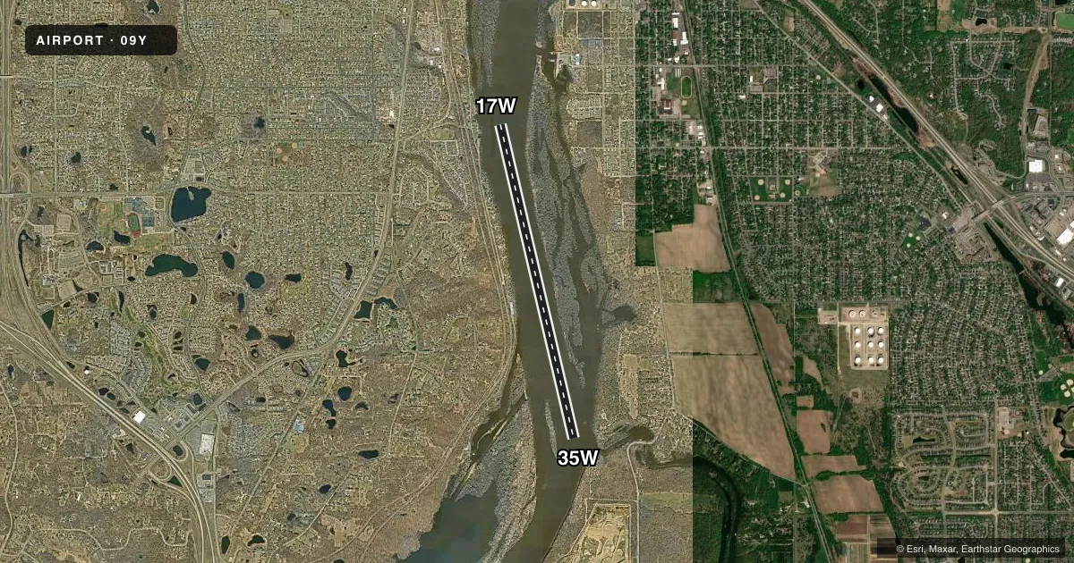
Runways & pattern
Full pagePattern entry · RWY 35W
RIGHT TRAFFICAirport sketch
Runways drawn to scale from FAA survey coordinates, rendered over satellite imagery. Not for navigation.
Approaches & charts
Services on the field
Fuel grades, oxygen, maintenance, ramp storage and lighting — as declared to the FAA by the airport operator.
Fuel & services
- Fuel
- 100LLA
- Oxygen (bottled)
- Not available
- Oxygen (bulk)
- Not available
- Airframe repair
- Minor
- Power plant repair
- Minor
- Other services
- BCHGR
Ramp & ground
- Transient storage
- Tie-down
- Landing fee
- No fee published
- Wind indicator
- Yes
- Segmented circle
- No
Fuel & FBOs
Cheapest 100LL and Jet A on the field and nearby. Always confirm with the FBO before taxi.
Airport notes
Surface conditions, obstructions, local procedures, lighting outages and other notes published with each FAA cycle.
General notes
- RIVER CHNL MRKD BY BUOYS.
- FLOATING DEBRIS ON RIVER AT ALL TIMES.
- FOR CD CTC MINNEAPOLIS APCH AT 612-713-4016.
Fuel notes
- 100LLFOR FUEL CALL AMGR.
VFR map & nearby airports
VFR sectional. Tap any ICAO chip to open that airport.
Key facts · 09Y
Answer card- ICAO
- 09Y
- Name
- WIPLINE
- Location
- INVER GROVE HGTS, MINNESOTA
- Elevation
- 687 ft MSL
- Traffic pattern altitude
- 1,687 ft MSL (1,000 AGL)
- Control tower
- Non-towered (use CTAF)
- Total runways
- 1
- Longest runway
- 17W/35W · 8,000 ft
- Published ILS approaches
- 0
- Published frequencies
- 1
- Magnetic variation
- 3°
- Current flight rules
- VFR
- Current wind
- 280° at 9 kt
- Favored runway now
- RWY 35W
Wipline sits in Inver Grove Hghts, Minnesota. The field elevation is 687 ft MSL. It has one runway. The water runway is 17W/35W and it is 8,000 ft long. The airport is not towered. CTAF is 122.9.
No ILS approaches are published here. Pattern altitude is not published. For light piston operations, use the standard 1,000 ft AGL unless the current FAA Chart Supplement says otherwise. The runway headings are magnetic. They are 167° and 347°.
There are no on-field FBOs listed. For 100LL, call the airport manager. For clearance delivery, contact Minneapolis ARTCC at 651-463-5588. The river channel is marked by buoys. Floating debris is present on the river at all times. That matters here more than a normal paved-field briefing. Plan a careful look at the water surface before takeoff or landing. Verify current river and local operating conditions before you go.