METAR & TAF KLVN
Current METAR
Observed 22:15Z
KLVN 262215Z AUTO 20009KT 10SM CLR 34/23 A2980 RMK AO2
- Wind
- 200° @ 9 kt
- Visibility
- 10 SM
- Temp / Dew
- 34°C / 23°C
- Altimeter
- 29.80 inHg
- Clouds
- CLR
- Density alt
- 3,620 ft
- Ceiling
- Unlimited
- Rules
- VFR
Airport info & contacts
Manager on record, flight service, ARTCC, attendance schedule and pattern altitude — published by the FAA and refreshed every 28 days.
Location
- From city
- 22 NM S
- VFR sectional
- TWIN CITIES
- ARTCC
- ZMP · MINNEAPOLIS
- NOTAM facility
- LVN (NOTAM-D)
Airport manager
- Name
- SAM SEAFELDT
- Phone
- 612-726-8140
- Address
- 8140 220TH STREET W., LAKEVILLE MN 55044
Flight service · Hours
- FSS PNM
- PRINCETON1-800-WX-BRIEF
- Attendance
- MON-FRI · 0800-1800
- SAT-SUN · 0800-1700
Frequencies
Tap any row to copy the frequency to your clipboard.
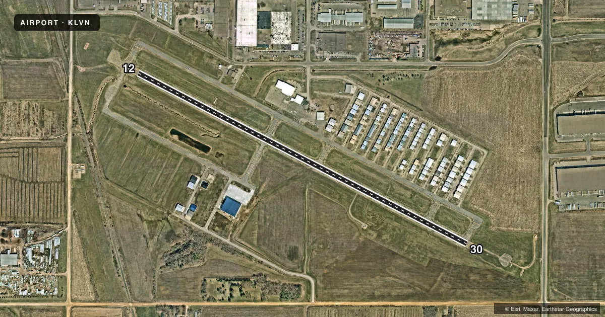
Runways & pattern
Full pagePattern entry · RWY 12
RIGHT TRAFFICRunway end performance
| End | TORA | TODA | ASDA | LDA | VGSI | Approach lights | Obstruction |
|---|---|---|---|---|---|---|---|
| 12 | 4,099' | 4,099' | 4,099' | 4,099' | PAPI 4-box left(3°) | — | 31', rr, 560' from thr, 197' R of cntrln, slope 11 |
| 30 | 4,099' | 4,099' | 4,099' | 3,707' | PAPI 4-box right(3°) | MALSR | 26', road, 408' from thr, 512' R of cntrln, slope 8 |
Declared distances in feet. TORA = takeoff run available, TODA = takeoff distance, ASDA = accelerate-stop, LDA = landing distance.
Airport sketch
Runways drawn to scale from FAA survey coordinates, rendered over satellite imagery. Not for navigation.
Approaches & charts
ILS · 1
Services on the field
Fuel grades, oxygen, maintenance, ramp storage and lighting — as declared to the FAA by the airport operator.
Fuel & services
- Fuel
- 100LLA
- Oxygen (bottled)
- Low pressure
- Airframe repair
- Major
- Power plant repair
- Major
- Other services
- INSTR,RNTL,SALES
Ramp & ground
- Transient storage
- Tie-down
- Hangar
- Landing fee
- No fee published
- Customs
- Not available
- Lighting schedule
- SEE RMK
- Beacon schedule
- SS-SR
- Beacon
- White / Green (civil land)(WG)
- Wind indicator
- Lighted
- Segmented circle
- No
Fuel & FBOs
Cheapest 100LL and Jet A on the field and nearby. Always confirm with the FBO before taxi.
Airport notes
Surface conditions, obstructions, local procedures, lighting outages and other notes published with each FAA cycle.
General notes
- DEER, BIRDS & WILDLIFE ON & INVOF ARPT.
- ULTRALIGHT OPNS PROHIBITED.
- HANGARS 400 FT NORTH FM CENTERLINE IN PRIMARY SURFACE.
- RY 30 DSGND AS CALM WND RY.
- FOR CD CTC MINNEAPOLIS APCH AT 612-713-4016.
- VOLUNTARY NOISE ABATEMENT PROCS IN EFCT. SEE ARPT WEBSITE FOR MORE INFO.
Lighting notes
- ACTVT MALSR RWY 30; REIL RWY 12; PAPI RWY 12, 30; HIRL RWY 12/30 PRESET TO LOW SS-SR: INCR INTST AND ACTVT - CTAF.
Fuel notes
- 100LL100LL SELF SERVICE FUEL AVBL 24 HRS WITH CREDIT CARD.
- AJET A FUEL SELF SERVE NOT AVBL.
Runway surface & condition
- 12/30REPAINTED. DISPLACEMENT ON 'NW' END NOW TAXIWAY.
Approach & departure obstructions
- 30RY 30 31:1 TO DSPLCD THLD.
VFR map & nearby airports
VFR sectional. Tap any ICAO chip to open that airport.
Key facts · KLVN
Answer card- ICAO
- KLVN
- Name
- AIRLAKE
- Location
- MINNEAPOLIS, MINNESOTA
- Elevation
- 960.4 ft MSL
- Traffic pattern altitude
- 1,960.4 ft MSL (1,000 AGL)
- Control tower
- Non-towered (use CTAF)
- Total runways
- 1
- Longest runway
- 12/30 · 4,099 ft
- Published ILS approaches
- 1
- Published frequencies
- 5
- Magnetic variation
- 3°
- Current flight rules
- VFR
- Current wind
- 200° at 9 kt
- Favored runway now
- RWY 12
Airlake sits in Minneapolis, Minnesota. Field elevation is 960.4 ft MSL. The airport has one runway. Runway 12/30 is 4,099 ft of asphalt, with magnetic headings 117° and 297°. There is no control tower. Pattern altitude is not published. Use the standard 1,000 ft AGL for light piston operations unless the current Chart Supplement says otherwise.
The field has one ILS approach to runway 30. Runway 30 is also the calm wind runway. MALSR is available for runway 30. REIL is available for runway 12. PAPI is available for both ends. Lighting is preset low from sunset to sunrise. Increase intensity and activate the lights via CTAF. Voluntary noise abatement procedures are in effect. Check the airport website or the airport operator for the current details before you go.
Aloft Aviation is on the field. It carries 100LL and Jet A. 100LL self-serve is available 24 hours with a credit card. Jet A self-serve is not available. The airport also has wildlife activity. Deer and birds have been reported on and near the field. Clearance delivery is handled through Minneapolis Approach. For a first arrival, pay attention to the displaced threshold on runway 30 and the published slope note near that end. Ultralight operations are prohibited.