METAR & TAF KSYN
Current METAR
Observed 06:15Z
KSYN 140615Z AUTO 33009KT 10SM OVC042 16/07 A2994 RMK AO2 T01570073
- Wind
- 330° @ 9 kt
- Visibility
- 10 SM
- Temp / Dew
- 16°C / 7°C
- Altimeter
- 29.94 inHg
- Clouds
- OVC
- Density alt
- 1,236 ft
- Ceiling
- 4,200 ft AGL
- Rules
- VFR
Airport info & contacts
Manager on record, flight service, ARTCC, attendance schedule and pattern altitude — published by the FAA and refreshed every 28 days.
Location
- From city
- 1 NM E
- VFR sectional
- OMAHA
- Pattern altitude
- 400 ft AGL · 1,320 ft MSL
- ARTCC
- ZMP · MINNEAPOLIS
- NOTAM facility
- SYN (NOTAM-D)
Airport manager
- Name
- JOHN QUILLING
- Phone
- 507-645-4030
- Address
- 1235 HIGHWAY 19 BLVD, STANTON MN 55018-7218
Flight service · Hours
- FSS PNM
- PRINCETON1-800-WX-BRIEF
- Attendance
- 0800-1600
Frequencies
Tap any row to copy the frequency to your clipboard.
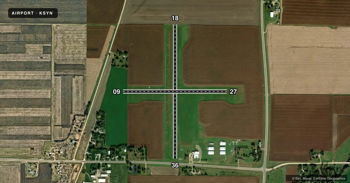
Runways & pattern
Full pagePattern entry · RWY 36
LEFT TRAFFIC| Runway | Heading (°M) | Length | Surface | Traffic |
|---|---|---|---|---|
| 18/36Favored | 177° / 357° | 2,582 ft | TURF | Standard L |
| 09/27 | 87° / 267° | 1,996 ft | TURF | Standard L |
Runway end performance
| End | TORA | TODA | ASDA | LDA | VGSI | Approach lights | Obstruction |
|---|---|---|---|---|---|---|---|
| 18 | — | — | — | — | — | — | 8', crops, 5' from thr, 0' R of cntrln, slope 0 |
| 36 | — | — | — | — | — | — | 18', road, 59' from thr, 0' R of cntrln, slope 3 |
| 27 | — | — | — | — | — | — | 8', crops, 3' from thr, 0' R of cntrln, slope 0 |
Declared distances in feet. TORA = takeoff run available, TODA = takeoff distance, ASDA = accelerate-stop, LDA = landing distance.
Airport sketch
Runways drawn to scale from FAA survey coordinates, rendered over satellite imagery. Not for navigation.
Approaches & charts
Services on the field
Fuel grades, oxygen, maintenance, ramp storage and lighting — as declared to the FAA by the airport operator.
Fuel & services
- Fuel
- 100LLUL94
- Oxygen (bottled)
- Not available
- Oxygen (bulk)
- Not available
- Airframe repair
- Major
- Power plant repair
- Major
- Other services
- INSTR,RNTL,SALES,TOW
Ramp & ground
- Transient storage
- Tie-down
- Hangar
- Landing fee
- No fee published
- Customs
- Not available
- Wind indicator
- Yes
- Segmented circle
- No
Fuel & FBOs
Cheapest 100LL and Jet A on the field and nearby. Always confirm with the FBO before taxi.
Airport notes
Surface conditions, obstructions, local procedures, lighting outages and other notes published with each FAA cycle.
General notes
- GLDR OPS SFC-8000 FT MSL ON & INVOF ARPT DURG DALGT HRS ON WKENDS EXC WINTER MONTHS.
- CROSSWIND RWY ENDS NOT VSB TO EACH OTR WHEN CROPS PRESENT.
- FOR CD CTC MINNEAPOLIS APCH AT 612-713-4016.
- NOT PLOWED WINTER MONTHS.
Approach & departure obstructions
- 09YELLOW CONES.
- 18YELLOW CONES.
- 27YELLOW CONES.
- 36RWY & DTHR MKD WITH YELLOW CONES.
- 09SEASONAL CROPS: RWY 27 SLP 0:1 WHEN CROPS PRSNT.
- 18SEASONAL CROPS: RWY 18 SLP 0:1 WHEN CROPS PRSNT.
- 36APCH SLP 20:1 TO DTHR.
Other notes
- ESTABD BFR 1959.
- TPA: 400 FT AGL ULTRALIGHT, 800 FT AGL GLDRS.
- 1FOR SVC AFT HRS CALL AMGR.
- MANAGERSYNAIRPORTMANAGER@GMAIL.COM.
VFR map & nearby airports
VFR sectional. Tap any ICAO chip to open that airport.
Key facts · KSYN
Answer card- ICAO
- KSYN
- Name
- STANTON AIRFIELD
- Location
- STANTON, MINNESOTA
- Elevation
- 920 ft MSL
- Traffic pattern altitude
- 1,320 ft MSL (400 AGL)
- Control tower
- Non-towered (use CTAF)
- Total runways
- 2
- Longest runway
- 18/36 · 2,582 ft
- Published ILS approaches
- 0
- Published frequencies
- 2
- Magnetic variation
- 3°
- Current flight rules
- VFR
- Current wind
- 330° at 9 kt
- Favored runway now
- RWY 36
Stanton Airfield is in Stanton, Minnesota. The field elevation is 920 ft MSL. It has two turf runways. The longest is runway 18/36 at 2,582 ft. There is no control tower, so plan for self-announce operations on CTAF 122.8. Pattern altitude is 400 ft AGL, which is 1,320 ft MSL.
No ILS approaches are published here. That matters if you are planning an IFR arrival or a low-ceiling departure. Check the current FAA Chart Supplement for the latest approach and airport data before you go.
Stanton Sport Aviation is on the field. It carries 100LL and UL94. For service after hours, call the airport manager. The airport is not plowed during winter months, so turf conditions can change fast after snow or thaw. Runway 09, runway 27, runway 18 and runway 36 are marked with yellow cones. Published remarks also note a displaced threshold on runway 36 with a 20 to 1 approach slope. Glider operations occur on and near the airport during daylight hours on weekends except winter months. That is worth keeping in mind when you are joining the pattern or planning a departure.