METAR & TAF KFBL
Current METAR
Observed 20:35Z
KFBL 272035Z AUTO 31006G15KT 10SM CLR 32/23 A2972 RMK AO2
- Wind
- 310° @ 6G15 kt
- Visibility
- 10 SM
- Temp / Dew
- 32°C / 23°C
- Altimeter
- 29.72 inHg
- Clouds
- CLR
- Density alt
- 3,603 ft
- Ceiling
- Unlimited
- Rules
- VFR
Airport info & contacts
Manager on record, flight service, ARTCC, attendance schedule and pattern altitude — published by the FAA and refreshed every 28 days.
Location
- From city
- 3 NM NW
- VFR sectional
- OMAHA
- ARTCC
- ZMP · MINNEAPOLIS
- NOTAM facility
- FBL (NOTAM-D)
Airport manager
- Name
- QUALITY AVIATION INC.
- Phone
- 507-332-0140
- Address
- 3401 HWY 21 WEST, STE 1, FARIBAULT MN 55021
Flight service · Hours
- FSS PNM
- PRINCETON1-800-WX-BRIEF
- Attendance
- MAY-SEP · 0800-1800
- OCT-APR · MON-FRI · 0800-1800
- OCT-APR · SAT · 1000-1500
- OCT-APR · SUN · Unattended
Frequencies
Tap any row to copy the frequency to your clipboard.
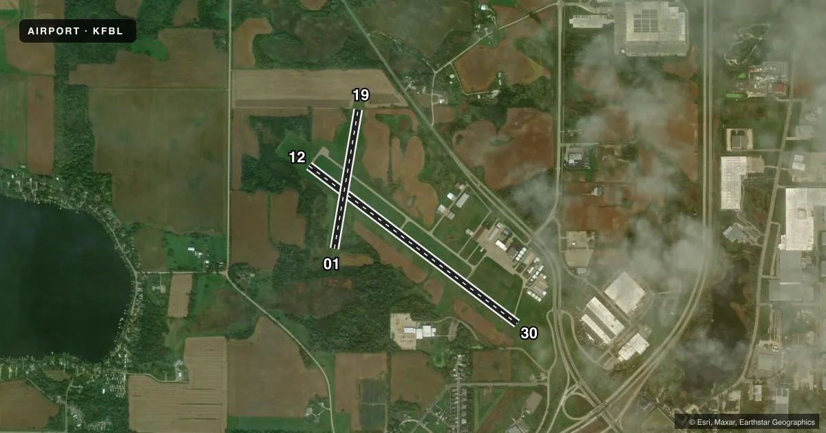
Runways & pattern
Full pagePattern entry · RWY 30
LEFT TRAFFIC| Runway | Heading (°M) | Length | Surface | Traffic |
|---|---|---|---|---|
| 12/30Favored | 125° / 305° | 4,257 ft | ASPH | Standard L |
| 01/19 | 8° / 188° | 2,300 ft | TURF | Standard L |
Runway end performance
| End | TORA | TODA | ASDA | LDA | VGSI | Approach lights | Obstruction |
|---|---|---|---|---|---|---|---|
| 12 | — | — | — | — | PAPI 4-box left(3°) | — | 37', tree, 263' from thr, 246' R of cntrln, slope 1 |
| 30 | — | — | — | — | PAPI 4-box left(3°) | — | 14', road, 580' from thr, 280' R of cntrln, slope 27 |
| 01 | — | — | — | — | — | — | 78', trees, 1295' from thr, 221' R of cntrln, slope 16 |
Declared distances in feet. TORA = takeoff run available, TODA = takeoff distance, ASDA = accelerate-stop, LDA = landing distance.
Airport sketch
Runways drawn to scale from FAA survey coordinates, rendered over satellite imagery. Not for navigation.
Approaches & charts
Services on the field
Fuel grades, oxygen, maintenance, ramp storage and lighting — as declared to the FAA by the airport operator.
Fuel & services
- Fuel
- 100LLA
- Oxygen (bottled)
- Low pressure
- Oxygen (bulk)
- Not available
- Airframe repair
- Major
- Power plant repair
- Major
- Other services
- GLD,INSTR,RNTL,SALES
Ramp & ground
- Transient storage
- Tie-down
- Hangar
- Landing fee
- No fee published
- Customs
- Not available
- Lighting schedule
- SEE RMK
- Beacon schedule
- SS-SR
- Beacon
- White / Green (civil land)(WG)
- Wind indicator
- Lighted
- Segmented circle
- No
Fuel & FBOs
Cheapest 100LL and Jet A on the field and nearby. Always confirm with the FBO before taxi.
Airport notes
Surface conditions, obstructions, local procedures, lighting outages and other notes published with each FAA cycle.
General notes
- GCO AVBL ON FREQ 121.725 THRU MSP CD & FLT SVCS.
- ULTRALIGHTS & GLDRS USE TAXIWAY AND EXTENDED TAXIWAY PARALLEL TO RY 12/30. ULTRALIGHTS & GLDRS USING TAXIWAY FLY PATTERN ON 'NE' SIDE OF RY 12/30.
- WHEN LNDG ON RY 12, BE ALERT FOR TURBULENCE & POSS WINDSHEAR WHEN WINDS ARE OUT OF THE SOUTH.
- FOR CD CTC MINNEAPOLIS APCH AT 612-713-4016.
- RWY 01-19 NOT PLOWED WINTER MONTHS. OPEN FOR SKIPLANES.
Lighting notes
- MIRL RY 12/30 PRESET TO LOW; TO INCR INTST AND ACTVT REIL RY 12 & RY 30 - CTAF.
Fuel notes
- 100LLSELF SVC FUEL WITH CREDIT CARD.
Approach & departure obstructions
- 12RWY 12 HAS 20 FT TREE 120 FT FM THE RWY END AND 153 FT R.
- 01RY 01/19 MARKED WITH YELLOW CONES.
- 12RY 12 PAPI OPERATE CONTINUOUSLY.
- 30RY 30 PAPI OPERATE CONTINUOUSLY.
- 30RY 30 ROAD +14, 580 FM END, 280R, APCH SLOPE 57:1 FM DSPLCD THLD.
Other notes
- 1FOR SVS AFT HRS CALL 507-838-7152
VFR map & nearby airports
VFR sectional. Tap any ICAO chip to open that airport.
Key facts · KFBL
Answer card- ICAO
- KFBL
- Name
- FARIBAULT MUNI-LIZ WALL STROHFUS FLD
- Location
- FARIBAULT, MINNESOTA
- Elevation
- 1,060.1 ft MSL
- Traffic pattern altitude
- 2,060.1 ft MSL (1,000 AGL)
- Control tower
- Non-towered (use CTAF)
- Total runways
- 2
- Longest runway
- 12/30 · 4,257 ft
- Published ILS approaches
- 0
- Published frequencies
- 4
- Magnetic variation
- 2°
- Current flight rules
- VFR
- Current wind
- 310° at 6 kt
- Favored runway now
- RWY 30
Faribault Muni-Liz Wall Strofhus Fld sits in Faribault, Minnesota. Field elevation is 1,060.1 ft MSL. The airport has two runways. The longest is 12/30 at 4,257 ft. Runway 01/19 is 2,300 ft turf. There is no control tower. CTAF and UNICOM are both 122.8. Minneapolis Approach handles the published approach and departure frequencies. No ILS approaches are published here.
Pattern altitude is not published. For light piston traffic, plan on the standard 1,000 ft AGL unless the current Chart Supplement or local procedures say otherwise. Quality Aviation is on the field. It carries 100LL and Jet A Prist. Self-serve fuel with credit card is available. If you need after-hours service, the published phone number is the one to use.
A few runway notes matter here. Runway 12 can see turbulence and windshear when winds are out of the south. Runway 30 has a road near the departure end with a published obstruction note. Runway 12 also has a tree close to the runway end on the right side. Runway 01/19 is marked with yellow cones. It is not plowed in winter and is open for ski planes. Runway 12/30 lighting is preset low. Use CTAF to increase intensity and turn on the runway end identifier lights. For a first-time arrival, check the current Chart Supplement for any local procedures, then brief the runway condition and lighting before you go.