METAR & TAF KTOB
Current METAR
Observed 00:55Z
KTOB 140055Z AUTO 31013KT 10SM OVC120 20/10 A2989 RMK AO2 T01960103
- Wind
- 310° @ 13 kt
- Visibility
- 10 SM
- Temp / Dew
- 20°C / 10°C
- Altimeter
- 29.89 inHg
- Clouds
- OVC
- Density alt
- 2,254 ft
- Ceiling
- 12,000 ft AGL
- Rules
- VFR
Airport info & contacts
Manager on record, flight service, ARTCC, attendance schedule and pattern altitude — published by the FAA and refreshed every 28 days.
Location
- From city
- 1 NM SE
- VFR sectional
- GREEN BAY
- ARTCC
- ZMP · MINNEAPOLIS
- NOTAM facility
- TOB (NOTAM-D)
Airport manager
- Name
- WAYNE TROM
- Phone
- 507-374-6245
- Address
- 806 AIRPORT DR S, DODGE CENTER MN 55927-9173
Flight service · Hours
- FSS PNM
- PRINCETON1-800-WX-BRIEF
- Attendance
- MON-FRI · 0700-1800
Frequencies
Tap any row to copy the frequency to your clipboard.
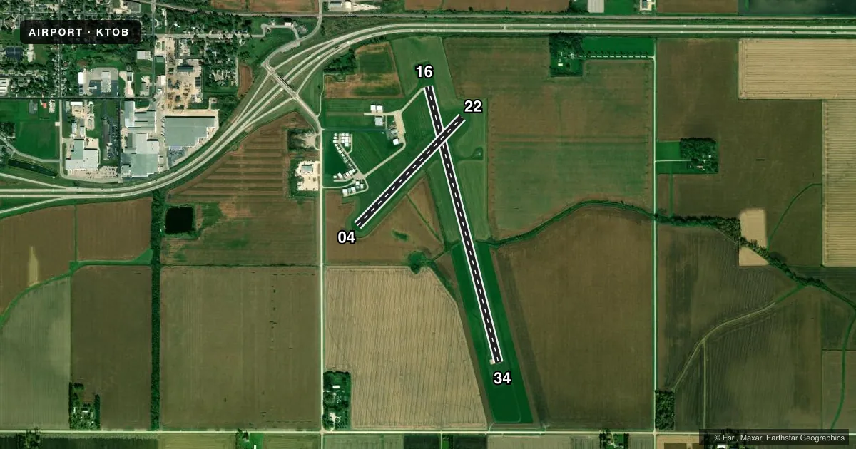
Runways & pattern
Full pagePattern entry · RWY 34
LEFT TRAFFIC| Runway | Heading (°M) | Length | Surface | Traffic |
|---|---|---|---|---|
| 16/34Favored | 164° / 344° | 4,500 ft | CONC | Standard L |
| 04/22 | 42° / 222° | 2,383 ft | TURF | Standard L |
Runway end performance
| End | TORA | TODA | ASDA | LDA | VGSI | Approach lights | Obstruction |
|---|---|---|---|---|---|---|---|
| 16 | — | — | — | — | PAPI 4-box left(3°) | — | — |
| 34 | — | — | — | — | PAPI 4-box left(3°) | — | — |
Declared distances in feet. TORA = takeoff run available, TODA = takeoff distance, ASDA = accelerate-stop, LDA = landing distance.
Airport sketch
Runways drawn to scale from FAA survey coordinates, rendered over satellite imagery. Not for navigation.
Approaches & charts
Services on the field
Fuel grades, oxygen, maintenance, ramp storage and lighting — as declared to the FAA by the airport operator.
Fuel & services
- Fuel
- 100LLA
- Airframe repair
- Major
- Power plant repair
- Major
- Other services
- INSTR,RNTL,SALES
Ramp & ground
- Transient storage
- Tie-down
- Hangar
- Landing fee
- No fee published
- Customs
- Not available
- Lighting schedule
- SEE RMK
- Beacon schedule
- SS-SR
- Beacon
- White / Green (civil land)(WG)
- Wind indicator
- Lighted
- Segmented circle
- No
Fuel & FBOs
Cheapest 100LL and Jet A on the field and nearby. Always confirm with the FBO before taxi.
Airport notes
Surface conditions, obstructions, local procedures, lighting outages and other notes published with each FAA cycle.
General notes
- WINDMILLS 1.5 NM SW OF ARPT.
- ULTRALIGHT TFC ON & INVOF ARPT.
- FOR CD CTC ROCHESTER APCH AT 507-424-8111.
- ARR/DEP BLDG ACES CODE: 1304.
Lighting notes
- ACTVT OR INCR INTST REIL RWY 16 & 34; PAPI RWY 16 & 34; MIRL RWY 16/34 - CTAF. MIRL RWY 16/34 PRESET LOW INTST.
Fuel notes
- 100LLFUEL AVBL H24 SELF SVC VIA CREDIT CARD.
Runway surface & condition
- 04/22NOT PLOWED WINTER MONTHS.
Approach & departure obstructions
- 04YELLOW CONES.
- 22YELLOW CONES.
VFR map & nearby airports
VFR sectional. Tap any ICAO chip to open that airport.
Key facts · KTOB
Answer card- ICAO
- KTOB
- Name
- DODGE CENTER
- Location
- DODGE CENTER, MINNESOTA
- Elevation
- 1,303.7 ft MSL
- Traffic pattern altitude
- 2,303.7 ft MSL (1,000 AGL)
- Control tower
- Non-towered (use CTAF)
- Total runways
- 2
- Longest runway
- 16/34 · 4,500 ft
- Published ILS approaches
- 0
- Published frequencies
- 3
- Magnetic variation
- 2°
- Current flight rules
- VFR
- Current wind
- 310° at 13 kt
- Favored runway now
- RWY 34
Dodge Center Airport is in Dodge Center, Minnesota. The field elevation is 1,303.7 ft MSL. It has two runways. The longest is runway 16/34 at 4,500 ft. Runway 04/22 is turf and is not plowed in winter. This is a non-towered field. CTAF is 122.9. Rochester Approach handles approach and departure services on 119.8 and 251.125. The Chart Supplement also lists clearance delivery through Rochester Approach at 507-424-8111.
No ILS approaches are published here. Pattern altitude is not published. Use the standard 1,000 ft AGL pattern for light piston traffic unless the current Chart Supplement or local procedures say otherwise. The field has runway lights on 16 and 34. Those lights are controlled by CTAF. PAPI and runway end identifier lights are also on 16 and 34. The remarks also note that ultralight traffic is on and near the airport. Yellow cones mark the ends of runways 04 and 22. Windmills sit 1.5 NM southwest of the airport, so keep that in mind on arrival and departure.
Dodge Center Airport has one on-field FBO. Dodge Center Airport carries 100LL and Jet A with Prist. 100LL is available 24 hours a day self-serve by credit card. The arrival and departure building access code is 1304.