METAR & TAF KAUM
Current METAR
Observed 00:15Z
KAUM 130015Z AUTO 23008KT 10SM CLR 26/09 A2984 RMK AO2 T02640090
- Wind
- 230° @ 8 kt
- Visibility
- 10 SM
- Temp / Dew
- 26°C / 9°C
- Altimeter
- 29.84 inHg
- Clouds
- CLR
- Density alt
- 2,949 ft
- Ceiling
- Unlimited
- Rules
- VFR
Airport info & contacts
Manager on record, flight service, ARTCC, attendance schedule and pattern altitude — published by the FAA and refreshed every 28 days.
Location
- From city
- 2 NM E
- VFR sectional
- CHICAGO
- ARTCC
- ZMP · MINNEAPOLIS
- NOTAM facility
- AUM (NOTAM-D)
Airport manager
- Name
- BRUCE W BUDAHN
- Phone
- 507-433-1813
- Address
- 710 21ST ST NE, AUSTIN MN 55912-4165
Flight service · Hours
- FSS PNM
- PRINCETON1-800-WX-BRIEF
- Attendance
- SAT · 0800-1600
- SUN · 0900-1500
- MON-FRI · 0800-1700
Frequencies
Tap any row to copy the frequency to your clipboard.
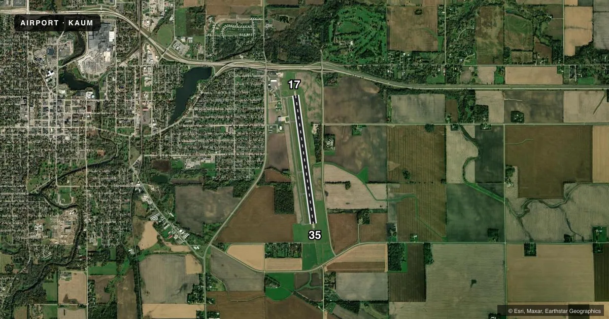
Runways & pattern
Full pagePattern entry · RWY 17
LEFT TRAFFICRunway end performance
| End | TORA | TODA | ASDA | LDA | VGSI | Approach lights | Obstruction |
|---|---|---|---|---|---|---|---|
| 17 | — | — | — | — | PAPI 4-box left(3°) | — | 80', trees, 1705' from thr, 607' R of cntrln, slope 18 |
| 35 | — | — | — | — | PAPI 4-box left(3°) | MALSR | — |
Declared distances in feet. TORA = takeoff run available, TODA = takeoff distance, ASDA = accelerate-stop, LDA = landing distance.
Airport sketch
Runways drawn to scale from FAA survey coordinates, rendered over satellite imagery. Not for navigation.
Approaches & charts
ILS · 1
Services on the field
Fuel grades, oxygen, maintenance, ramp storage and lighting — as declared to the FAA by the airport operator.
Fuel & services
- Fuel
- 100LLA
- Oxygen (bottled)
- Not available
- Oxygen (bulk)
- Not available
- Airframe repair
- Major
- Power plant repair
- Major
- Other services
- INSTR,RNTL,SALES
Ramp & ground
- Transient storage
- Tie-down
- Hangar
- Landing fee
- No fee published
- Customs
- Not available
- Lighting schedule
- SEE RMK
- Beacon schedule
- SS-SR
- Beacon
- White / Green (civil land)(WG)
- Wind indicator
- Lighted
- Segmented circle
- No
Fuel & FBOs
Cheapest 100LL and Jet A on the field and nearby. Always confirm with the FBO before taxi.
Airport notes
Surface conditions, obstructions, local procedures, lighting outages and other notes published with each FAA cycle.
General notes
- MIGRATORY WATERFOWL & DEER INVOF ARPT.
- FOR CD CTC ROCHESTER APCH AT 507-424-8111.
Lighting notes
- ACTVT MALSR RWY 35; REIL RWY 17; PAPI RWY 17 & 35; HIRL RWY 17/35 DALGT - CTAF. HIRL RWY 17/35 PRESET LOW INTST AT NIGHT; TO INCR INTST - CTAF.
Fuel notes
- 100LLAFT HRS CTC FBO 507-433-1813.
Other notes
- MANAGER507-433-1813.
VFR map & nearby airports
VFR sectional. Tap any ICAO chip to open that airport.
Key facts · KAUM
Answer card- ICAO
- KAUM
- Name
- AUSTIN MUNI
- Location
- AUSTIN, MINNESOTA
- Elevation
- 1,233.5 ft MSL
- Traffic pattern altitude
- 2,233.5 ft MSL (1,000 AGL)
- Control tower
- Non-towered (use CTAF)
- Total runways
- 1
- Longest runway
- 17/35 · 5,800 ft
- Published ILS approaches
- 1
- Published frequencies
- 4
- Magnetic variation
- 0°
- Current flight rules
- VFR
- Current wind
- 230° at 8 kt
- Favored runway now
- RWY 17
Austin Muni is in Austin, Minnesota. The field elevation is 1,233.5 ft MSL. It has one runway, 17/35, which is 5,800 ft long and paved with concrete. There is no control tower. The airport uses CTAF 122.7 and Rochester Approach handles clearance delivery and approach services.
The published ILS is for runway 35. Lighting is pilot controlled on CTAF. Runway 35 has MALSR. Runway 17 has REIL. PAPI is available on both runway ends. The pattern altitude is not published, so use the standard 1,000 ft AGL for light piston traffic unless the current Chart Supplement says otherwise.
Austin Aeroflight is on the field. It carries 100LL and Jet A Prist. After hours, contact the FBO at 507-433-1813 for 100LL fuel. The airport manager phone number is the same. Be ready for wildlife on or near the airport. Migratory waterfowl and deer are noted in the published remarks. If you are planning a night arrival or a first trip in, brief the lighting setup before you go. The runway lights are preset to low intensity at night. Use CTAF to increase intensity if needed.