METAR & TAF 5D2
5D2 does not publish a METAR.
Showing the nearest reporting station: KAEL (ALBERT LEA MUNI) · 15.7 NM away. Conditions at 5D2 may differ.
METAR · KAEL
Observed 18:55Z
KAEL 271855Z AUTO 30011G16KT 10SM CLR 32/24 A2976 RMK AO2 T03170244
- Wind
- 300° @ 11G16 kt
- Visibility
- 10 SM
- Temp / Dew
- 32°C / 24°C
- Altimeter
- 29.76 inHg
- Clouds
- CLR
- Density alt
- 3,759 ft
- Ceiling
- Unlimited
- Rules
- VFR
Airport info & contacts
Manager on record, flight service, ARTCC, attendance schedule and pattern altitude — published by the FAA and refreshed every 28 days.
Location
- From city
- 1 NM E
- VFR sectional
- OMAHA
- ARTCC
- ZMP · MINNEAPOLIS
- NOTAM facility
- FOD (NOTAM-D)
Airport manager
- Name
- DR MIKE DIERENFELD
- Phone
- 641-324-1084
- Address
- CENTRAL AVE, NORTHWOOD IA 50459
Flight service · Hours
- FSS FOD
- FORT DODGE1-800-WX-BRIEF
- Attendance
- Unattended
Frequencies
Tap any row to copy the frequency to your clipboard.
Runways & pattern
Full pagePattern entry · RWY 35
LEFT TRAFFICRunway end performance
| End | TORA | TODA | ASDA | LDA | VGSI | Approach lights | Obstruction |
|---|---|---|---|---|---|---|---|
| 17 | — | — | — | — | — | — | 20', road, 0' from thr, 120' R of cntrln, slope 0 |
| 35 | — | — | — | — | — | — | 18', road, 0' from thr, 120' R of cntrln, slope 0 |
Declared distances in feet. TORA = takeoff run available, TODA = takeoff distance, ASDA = accelerate-stop, LDA = landing distance.
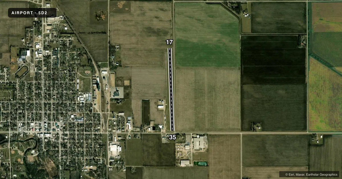
Airport sketch
Runways drawn to scale from FAA survey coordinates, rendered over satellite imagery. Not for navigation.
Approaches & charts
Services on the field
Fuel grades, oxygen, maintenance, ramp storage and lighting — as declared to the FAA by the airport operator.
Fuel & services
- Fuel
- Not available
- Other services
- AGRI
Ramp & ground
- Transient storage
- Tie-down
- Hangar
- Landing fee
- No fee published
- Lighting schedule
- SEE RMK
- Wind indicator
- Lighted
- Segmented circle
- No
Fuel & FBOs
Cheapest 100LL and Jet A on the field and nearby. Always confirm with the FBO before taxi.
Airport notes
Surface conditions, obstructions, local procedures, lighting outages and other notes published with each FAA cycle.
General notes
- CROP DUSTING ON & INVOF ARPT.
- RY 17/35 +18 FT BIT RD 100 FT E & PARALLEL CNTRLN.
- FOR CD CTC ROCHESTER APCH AT 507-424-8111. FOR CD WHEN ROCHESTER APCH IS CLOSED, CTC MINNEAPOLIS ARTCC AT 651-463-5588.
- NO SNOW REMOVAL. ARPT CLOSED WHEN SNOW CONDITIONS EXIST.
Lighting notes
- SOLAR LIGHTS OPERATE SUNSET TO SUNRISE.
Runway surface & condition
- 17/35SOLAR LIGHTS MOUNTED ON YELLOW CONES.
Approach & departure obstructions
- 17RYS 17& 35 THLDS & EDGES MKD WITH YELLOW CONES.
- 35RWYS 17 & 35 THLDS & EDGES MKD WITH YELLOW CONES.
- 17CONTROLLING OBSTRUCTION EXCEEDS A 45 DEGREE SLOPE RY 17/35 +18FT RD 100 FT E & PARALLEL CNTRLN.
VFR map & nearby airports
VFR sectional. Tap any ICAO chip to open that airport.
Key facts · 5D2
Answer card- ICAO
- 5D2
- Name
- NORTHWOOD MUNI
- Location
- NORTHWOOD, IOWA
- Elevation
- 1,226 ft MSL
- Traffic pattern altitude
- 2,226 ft MSL (1,000 AGL)
- Control tower
- Non-towered (use CTAF)
- Total runways
- 1
- Longest runway
- 17/35 · 3,300 ft
- Published ILS approaches
- 0
- Published frequencies
- 1
- Magnetic variation
- 3°
- Current flight rules
- VFR
- Current wind
- 300° at 11 kt
- Favored runway now
- RWY 35
Northwood Muni sits in Northwood, Iowa. The field elevation is 1,226 ft MSL. It has one runway. Runway 17/35 is 3,300 ft of turf, with magnetic headings 178° and 358°. There is no control tower. CTAF is 122.9.
No ILS approaches are published here. The pattern altitude is not published, so use the standard 1,000 ft AGL for light piston operations unless the current Chart Supplement says otherwise. That puts the pattern at 2,226 ft MSL based on the field elevation.
There are no on-field FBOs listed. Check with the airport operator or the field on CTAF for current services before you go. Published remarks matter here. No snow removal is provided. The airport is closed when snow conditions exist. Crop dusting occurs on and near the airport, so expect low-level ag work traffic. Runway 17 and 35 touchdown zones and edges are marked with yellow cones. Solar lights operate from sunset to sunrise. There is also an 18-foot road 100 feet east and parallel to the runway centerline. That is worth keeping in mind on final and during rollout.
For clearance delivery, contact Rochester Approach or Minneapolis ARTCC when Rochester is closed. This is a turf strip with a single runway, so check surface condition and local traffic before committing.