METAR & TAF D02
D02 does not publish a METAR.
Showing the nearest reporting station: KCCY (NORTHEAST IOWA RGNL) · 15.5 NM away. Conditions at D02 may differ.
METAR · KCCY
Observed 07:15Z
KCCY 270715Z AUTO 18005KT 9SM CLR 23/23 A2980 RMK AO2
- Wind
- 180° @ 5 kt
- Visibility
- 9 SM
- Temp / Dew
- 23°C / 23°C
- Altimeter
- 29.80 inHg
- Clouds
- CLR
- Density alt
- 2,557 ft
- Ceiling
- Unlimited
- Rules
- VFR
Airport info & contacts
Manager on record, flight service, ARTCC, attendance schedule and pattern altitude — published by the FAA and refreshed every 28 days.
Location
- From city
- 1 NM NE
- VFR sectional
- CHICAGO
- ARTCC
- ZMP · MINNEAPOLIS
- NOTAM facility
- FOD (NOTAM-D)
Airport manager
- Name
- BROCK WATERS CITY ADMINISTRATOR
- Phone
- 641-832-7945
- Address
- 806 MAIN, P.O. BOX 29, OSAGE IA 50461-1439
Flight service · Hours
- FSS FOD
- FORT DODGE1-800-WX-BRIEF
- Attendance
- Unattended
Frequencies
Tap any row to copy the frequency to your clipboard.
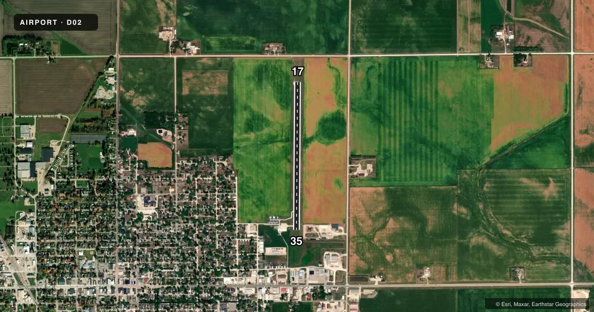
Runways & pattern
Full pagePattern entry · RWY 17
LEFT TRAFFICRunway end performance
| End | TORA | TODA | ASDA | LDA | VGSI | Approach lights | Obstruction |
|---|---|---|---|---|---|---|---|
| 17 | — | — | — | — | — | — | 21', road, 600' from thr, 0' R of cntrln, slope 19 |
| 35 | — | — | — | — | — | — | 40', pline, 930' from thr, 0' R of cntrln, slope 18 |
Declared distances in feet. TORA = takeoff run available, TODA = takeoff distance, ASDA = accelerate-stop, LDA = landing distance.
Airport sketch
Runways drawn to scale from FAA survey coordinates, rendered over satellite imagery. Not for navigation.
Approaches & charts
Services on the field
Fuel grades, oxygen, maintenance, ramp storage and lighting — as declared to the FAA by the airport operator.
Fuel & services
- Fuel
- Not available
- Airframe repair
- Not available
- Power plant repair
- Not available
- Other services
- AGRI
Ramp & ground
- Transient storage
- Tie-down
- Landing fee
- No fee published
- Lighting schedule
- SS-SR
- Wind indicator
- Yes
- Segmented circle
- No
Fuel & FBOs
Cheapest 100LL and Jet A on the field and nearby. Always confirm with the FBO before taxi.
Airport notes
Surface conditions, obstructions, local procedures, lighting outages and other notes published with each FAA cycle.
General notes
- FOR CD CTC ROCHESTER APCH AT 507-424-8111. FOR CD WHEN ROCHESTER APCH IS CLOSED, CTC MINNEAPOLIS ARTCC AT 651-463-5588.
Other notes
- PRVDD THE APCH TO EACH RWY IS MAINTAINED FOR MIN 20:1 GLIDE SLOPE AND THE TRANSITIONAL SURFACE BE MAINTAINED FOR A 7:1 SLOPE.
- UNICOM LCTD OSAGE POLICE STN, 24 HR OPN, PHONE 641-732-3777.
- 17/35CTN, RWY IS SUBJECT TO FROST HEAVES
VFR map & nearby airports
VFR sectional. Tap any ICAO chip to open that airport.
Key facts · D02
Answer card- ICAO
- D02
- Name
- OSAGE MUNI
- Location
- OSAGE, IOWA
- Elevation
- 1,168 ft MSL
- Traffic pattern altitude
- 2,168 ft MSL (1,000 AGL)
- Control tower
- Non-towered (use CTAF)
- Total runways
- 1
- Longest runway
- 17/35 · 3,400 ft
- Published ILS approaches
- 0
- Published frequencies
- 2
- Magnetic variation
- 3°
- Current flight rules
- VFR
- Current wind
- 180° at 5 kt
- Favored runway now
- RWY 17
Osage Muni (D02) sits in Osage, Iowa. Field elevation is 1,168 ft MSL. The airport has one runway. Runway 17/35 is 3,400 ft of asphalt, which is the longest runway on the field. There is no control tower, so use CTAF 122.8 for self-announce traffic. UNICOM is also 122.8. The published pattern altitude is not listed, so plan on the standard 1,000 ft AGL for light piston operations unless the current Chart Supplement says otherwise. That puts the pattern at about 2,168 ft MSL based on the field elevation.
No ILS approaches are published here. If you need instrument details, check the current Chart Supplement before departure. The published remarks also note that the runway is subject to frost heaves. That is worth a close look on rollout and during taxi. Clearance delivery is handled through Rochester Approach at 507-424-8111. If Rochester Approach is closed, use Minneapolis ARTCC at 651-463-5588. UNICOM is located at the Osage Police Station and is open 24 hours. For a first-time arrival, expect a quiet non-towered field with a single runway and standard Midwest surface conditions. Verify the runway condition before you go if temperatures have been near freezing.