METAR & TAF KCJJ
KCJJ does not publish a METAR.
Showing the nearest reporting station: KDEH (DECORAH MUNI) · 18.0 NM away. Conditions at KCJJ may differ.
METAR · KDEH
Observed 04:35Z
KDEH 270435Z AUTO 00000KT 10SM SCT024 BKN028 BKN033 A2982 RMK AO2
- Wind
- 000° @ 0 kt
- Visibility
- 10 SM
- Temp / Dew
- —
- Altimeter
- 29.82 inHg
- Clouds
- BKN
- Density alt
- —
- Ceiling
- 2,800 ft AGL
- Rules
- MVFR
Airport info & contacts
Manager on record, flight service, ARTCC, attendance schedule and pattern altitude — published by the FAA and refreshed every 28 days.
Location
- From city
- 1 NM SW
- VFR sectional
- CHICAGO
- ARTCC
- ZMP · MINNEAPOLIS
- NOTAM facility
- FOD (NOTAM-D)
Airport manager
- Name
- CLAIR PECINOVSKY
- Phone
- 563-547-4898
- Address
- 12848 WELL ROAD, CRESCO IA 52136
Flight service · Hours
- FSS FOD
- FORT DODGE1-800-WX-BRIEF
- Attendance
- Unattended
Frequencies
Tap any row to copy the frequency to your clipboard.
Runways & pattern
Full pagePattern entry · RWY 15
LEFT TRAFFICRunway end performance
| End | TORA | TODA | ASDA | LDA | VGSI | Approach lights | Obstruction |
|---|---|---|---|---|---|---|---|
| 15 | — | — | — | — | — | — | 74', tree, 1736' from thr, 86' R of cntrln, slope 20 |
| 33 | — | — | — | — | — | — | 25', pole, 714' from thr, 228' R of cntrln, slope 20 |
Declared distances in feet. TORA = takeoff run available, TODA = takeoff distance, ASDA = accelerate-stop, LDA = landing distance.
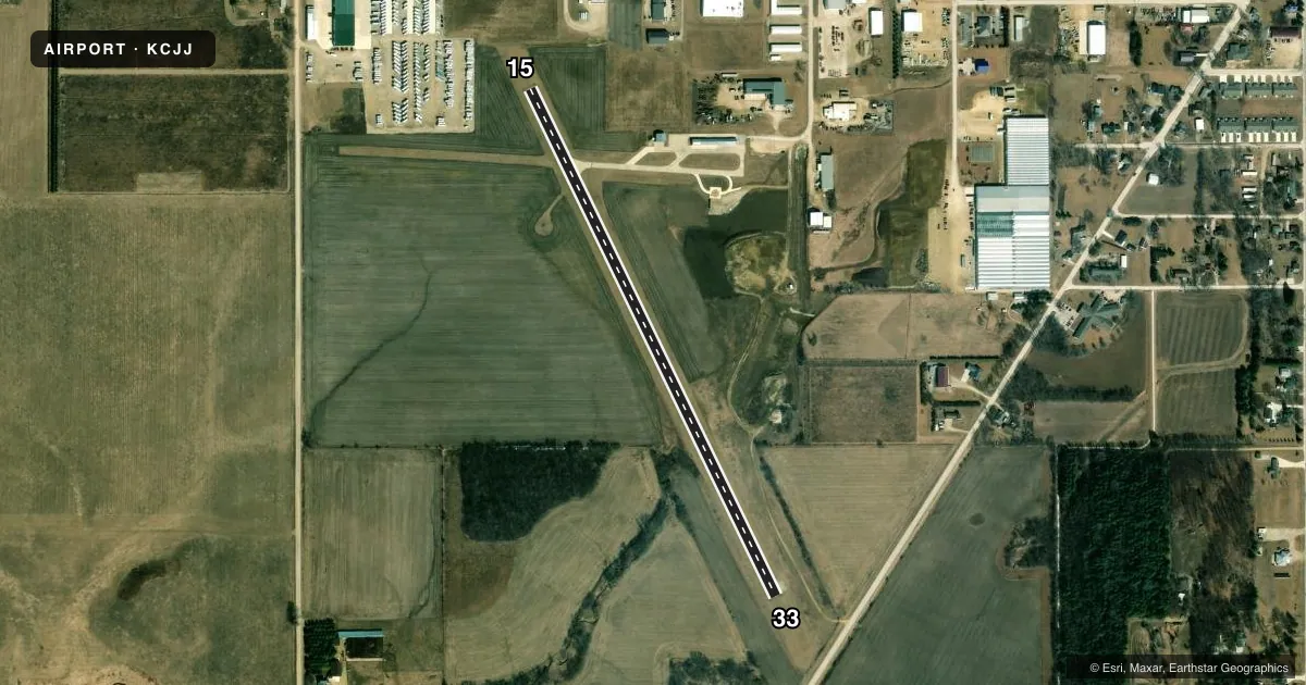
Airport sketch
Runways drawn to scale from FAA survey coordinates, rendered over satellite imagery. Not for navigation.
Approaches & charts
Services on the field
Fuel grades, oxygen, maintenance, ramp storage and lighting — as declared to the FAA by the airport operator.
Fuel & services
- Fuel
- Not available
- Oxygen (bottled)
- Not available
- Oxygen (bulk)
- Not available
- Airframe repair
- Not available
- Power plant repair
- Not available
Ramp & ground
- Transient storage
- Tie-down
- Landing fee
- No fee published
- Customs
- Not available
- Lighting schedule
- SEE RMK
- Wind indicator
- Lighted
- Segmented circle
- No
Fuel & FBOs
Cheapest 100LL and Jet A on the field and nearby. Always confirm with the FBO before taxi.
Airport notes
Surface conditions, obstructions, local procedures, lighting outages and other notes published with each FAA cycle.
General notes
- BE ALERT FOR ULTRALIGHT ACTIVITY ON & INVOF ARPT.
- FOR CD CTC ROCHESTER APCH AT 507-424-8111. FOR CD WHEN ROCHESTER APCH IS CLOSED, CTC MINNEAPOLIS ARTCC AT 651-463-5588.
- SNOW REMOVAL DELAYED AT TIMES; CONFIRM RWY CONDITIONS PRIOR TO USE: CALL 563-547-4898 OR AMGR, 563-379-5898.
Lighting notes
- ACTVT LIRL RWY 15/33 - 122.7.
Other notes
- THIS AIRPORT HAS BEEN SURVEYED BY THE NATIONAL GEODETIC SURVEY.
- CTAF/UNICOM OTS INDEFLY.
- ANSWERED BY POLICE; NOT ON FIELD.
VFR map & nearby airports
VFR sectional. Tap any ICAO chip to open that airport.
Key facts · KCJJ
Answer card- ICAO
- KCJJ
- Name
- ELLEN CHURCH FLD
- Location
- CRESCO, IOWA
- Elevation
- 1,279 ft MSL
- Traffic pattern altitude
- 2,279 ft MSL (1,000 AGL)
- Control tower
- Non-towered (use CTAF)
- Total runways
- 1
- Longest runway
- 15/33 · 2,949 ft
- Published ILS approaches
- 0
- Published frequencies
- 2
- Magnetic variation
- 2°
- Current flight rules
- MVFR
- Current wind
- 000° at 0 kt
- Favored runway now
- –
Ellen Church Fld is in Cresco, Iowa. The field elevation is 1,279 ft MSL. It has one runway, 15/33, which is 2,949 ft long and paved concrete. There is no control tower. No ILS approaches are published here.
Pattern altitude is not published. Use the standard 1,000 ft AGL pattern unless the current Chart Supplement or airport manager says otherwise. That puts the pattern at about 2,279 ft MSL based on the listed field elevation. The airport is non-towered, so plan to self-announce and keep a close ear on the CTAF. The published remarks also say the CTAF and UNICOM frequencies are out of service indefinitely, so verify current local procedures before you go.
There are no on-field FBOs listed. Snow removal can be delayed at times, so call ahead for runway condition updates before a winter arrival. The remarks also call out ultralight activity in and near the airport. Low-intensity runway lighting on 15/33 is activated by keying the microphone on 122.7. For clearance delivery, contact Rochester Approach. If Rochester is closed, contact Minneapolis ARTCC. Pilots should also pay attention to the magnetic runway headings. They are 154° for runway 15 and 334° for runway 33.