METAR & TAF KDEH
Current METAR
Observed 22:35Z
KDEH 262235Z AUTO 22004KT 10SM CLR A2983 RMK AO2
- Wind
- 220° @ 4 kt
- Visibility
- 10 SM
- Temp / Dew
- —
- Altimeter
- 29.83 inHg
- Clouds
- CLR
- Density alt
- —
- Ceiling
- Unlimited
- Rules
- VFR
Airport info & contacts
Manager on record, flight service, ARTCC, attendance schedule and pattern altitude — published by the FAA and refreshed every 28 days.
Location
- From city
- 2 NM SE
- VFR sectional
- CHICAGO
- ARTCC
- ZMP · MINNEAPOLIS
- NOTAM facility
- DEH (NOTAM-D)
Airport manager
- Name
- MIKE CONNELL
- Phone
- 563-382-8338
- Address
- 1705 HIGHWAY 9, DECORAH IA 52101
Flight service · Hours
- FSS FOD
- FORT DODGE1-800-WX-BRIEF
- Attendance
- MON-SAT
- SUN · ON CALL
Frequencies
Tap any row to copy the frequency to your clipboard.
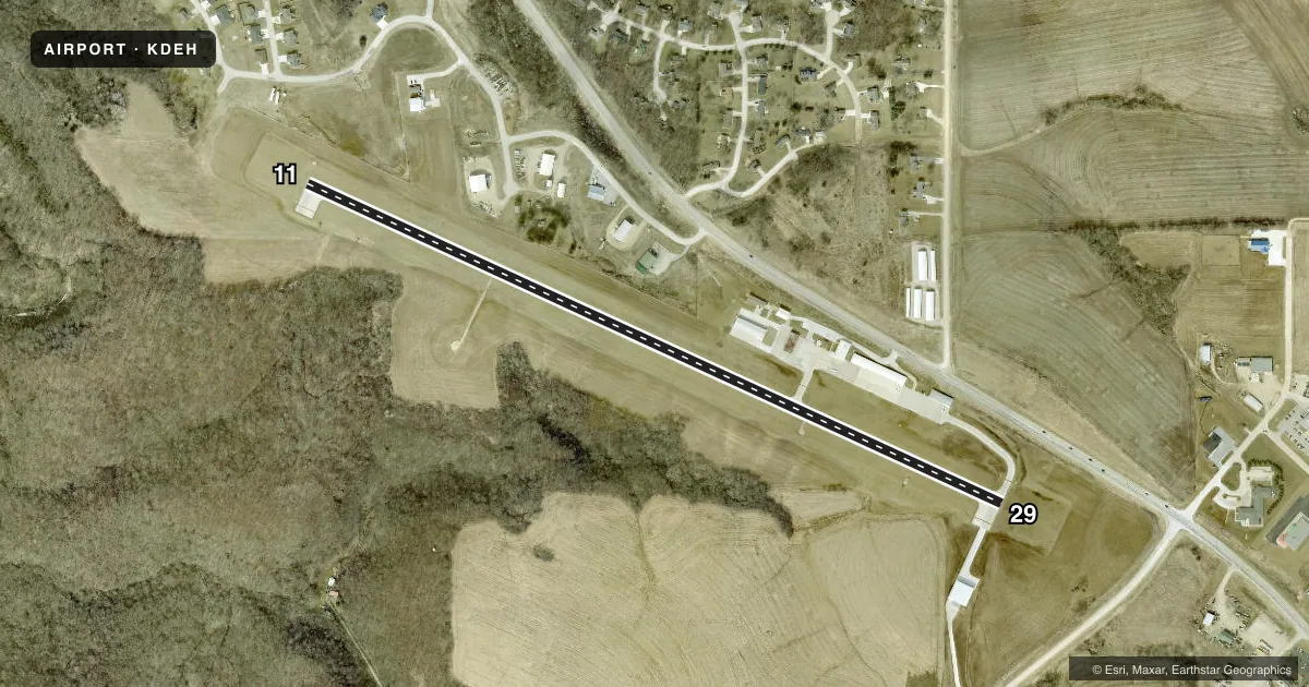
Runways & pattern
Full pagePattern entry · RWY 29
LEFT TRAFFICRunway end performance
| End | TORA | TODA | ASDA | LDA | VGSI | Approach lights | Obstruction |
|---|---|---|---|---|---|---|---|
| 11 | — | — | — | — | PAPI 2-box left(3°) | — | — |
| 29 | — | — | — | — | VASI 4-box left(4°) | — | 30', tree, 950' from thr, 176' R of cntrln, slope 25 |
Declared distances in feet. TORA = takeoff run available, TODA = takeoff distance, ASDA = accelerate-stop, LDA = landing distance.
Airport sketch
Runways drawn to scale from FAA survey coordinates, rendered over satellite imagery. Not for navigation.
Approaches & charts
Services on the field
Fuel grades, oxygen, maintenance, ramp storage and lighting — as declared to the FAA by the airport operator.
Fuel & services
- Fuel
- 100LLA+
- Oxygen (bottled)
- Not available
- Oxygen (bulk)
- Not available
- Airframe repair
- Major
- Power plant repair
- Major
- Other services
- INSTR,RNTL
Ramp & ground
- Transient storage
- Tie-down
- Hangar
- Landing fee
- No fee published
- Customs
- Not available
- Lighting schedule
- SEE RMK
- Beacon schedule
- SS-SR
- Beacon
- White / Green (civil land)(WG)
- Wind indicator
- Lighted
- Segmented circle
- No
Fuel & FBOs
Cheapest 100LL and Jet A on the field and nearby. Always confirm with the FBO before taxi.
Airport notes
Surface conditions, obstructions, local procedures, lighting outages and other notes published with each FAA cycle.
General notes
- FOR CD CTC MINNEAPOLIS ARTCC AT 651-463-5588.
Lighting notes
- DUSK-DAWN. MIRL RY 11/29 PRESET ON LOW INTST; TO INCR INTST & ACTVT VASI RY 29 & PAPI RY 11 & REIL RYS 11 & 29 - CTAF.
Other notes
- 3ATNDNC SCHEDULE SUN CALL 563-382-8338.
- OWNERBRETT WILLIE ARPT COMM 563-380-4089.
VFR map & nearby airports
VFR sectional. Tap any ICAO chip to open that airport.
Key facts · KDEH
Answer card- ICAO
- KDEH
- Name
- DECORAH MUNI
- Location
- DECORAH, IOWA
- Elevation
- 1,157.5 ft MSL
- Traffic pattern altitude
- 2,157.5 ft MSL (1,000 AGL)
- Control tower
- Non-towered (use CTAF)
- Total runways
- 1
- Longest runway
- 11/29 · 4,001 ft
- Published ILS approaches
- 0
- Published frequencies
- 2
- Magnetic variation
- 1°
- Current flight rules
- VFR
- Current wind
- 220° at 4 kt
- Favored runway now
- RWY 29
Decorah Muni sits in Decorah, Iowa. The field elevation is 1,157.5 ft MSL. It has one runway, 11/29, which is 4,001 ft long and paved. This is an untowered airport. CTAF and UNICOM are both 122.8. No ILS approaches are published here, so plan with the current chart and the weather you have in hand.
The pattern altitude is not published. Use the standard 1,000 ft AGL pattern unless local guidance says otherwise. Connell Flying Service is on the field. It carries 100LL and Jet A. Call ahead if you need current service details. The published remarks also note that runway lights on 11/29 are preset low from dusk to dawn. Use CTAF to increase intensity. Use it to activate the PAPI on runway 11, the VASI on runway 29 and the REILs on both ends.
For a first-time arrival, the big things are the single runway layout, the lack of tower service and the lighting setup after dark. Clearance delivery is handled through Minneapolis ARTCC. If you are planning a Sunday arrival, the attendance schedule requires a call first. Check the current FAA Chart Supplement for any updated operational notes before you go.