METAR & TAF KIIB
Current METAR
Observed 15:15Z
KIIB 271515Z AUTO 25009KT 10SM CLR 30/26 A2978 RMK AO2 T03030258
- Wind
- 250° @ 9 kt
- Visibility
- 10 SM
- Temp / Dew
- 30°C / 26°C
- Altimeter
- 29.78 inHg
- Clouds
- CLR
- Density alt
- 3,188 ft
- Ceiling
- Unlimited
- Rules
- VFR
Airport info & contacts
Manager on record, flight service, ARTCC, attendance schedule and pattern altitude — published by the FAA and refreshed every 28 days.
Location
- From city
- 3 NM SW
- VFR sectional
- CHICAGO
- ARTCC
- ZMP · MINNEAPOLIS
- NOTAM facility
- IIB (NOTAM-D)
Airport manager
- Name
- BRETT SOUKUP
- Phone
- (319) 332-0118
- Address
- 1684 - 230TH STREET, P.O. BOX 214, INDEPENDENCE IA 50644-0506
Flight service · Hours
- FSS FOD
- FORT DODGE1-800-WX-BRIEF
- Attendance
- 0700-DUSK
Frequencies
Tap any row to copy the frequency to your clipboard.
Runways & pattern
Full pagePattern entry · RWY 18
LEFT TRAFFICRunway end performance
| End | TORA | TODA | ASDA | LDA | VGSI | Approach lights | Obstruction |
|---|---|---|---|---|---|---|---|
| 18 | — | — | — | — | PAPI 2-box left(3°) | — | — |
| 36 | — | — | — | — | PAPI 2-box left(3°) | — | — |
Declared distances in feet. TORA = takeoff run available, TODA = takeoff distance, ASDA = accelerate-stop, LDA = landing distance.
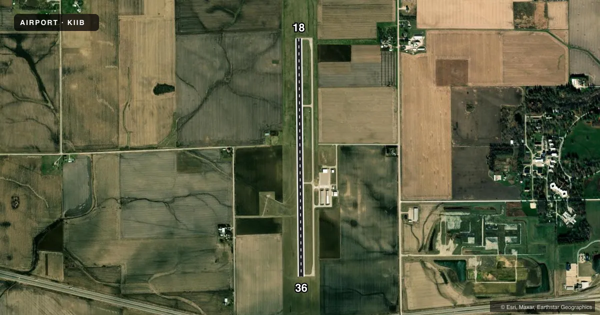
Airport sketch
Runways drawn to scale from FAA survey coordinates, rendered over satellite imagery. Not for navigation.
Approaches & charts
Services on the field
Fuel grades, oxygen, maintenance, ramp storage and lighting — as declared to the FAA by the airport operator.
Fuel & services
- Fuel
- 100LLA
- Oxygen (bottled)
- Not available
- Oxygen (bulk)
- Not available
- Airframe repair
- Major
- Power plant repair
- Major
- Other services
- CHTR,INSTR,RNTL
Ramp & ground
- Transient storage
- Tie-down
- Hangar
- Landing fee
- No fee published
- Customs
- Not available
- Lighting schedule
- SEE RMK
- Beacon schedule
- SS-SR
- Beacon
- White / Green (civil land)(WG)
- Wind indicator
- Lighted
- Segmented circle
- Yes
Fuel & FBOs
Cheapest 100LL and Jet A on the field and nearby. Always confirm with the FBO before taxi.
Airport notes
Surface conditions, obstructions, local procedures, lighting outages and other notes published with each FAA cycle.
General notes
- PAEW PERFORMING SNOW REMOVAL OPS WILL MONITOR CTAF.
- AG OPS DURG SUMMER MONTHS.
- RWY 36 IS CALM WIND RWY.
- FOR CD CTC DES MOINES AT APCH 515-974-8016. WHEN DES MOINES APP CLSD, FOR CD CTC MINNEAPOLIS ARTCC AT 651-463-5588.
Lighting notes
- MIRL RWY 18/36 PRESET LOW INTST; TO ACTVT HIGHER INTST & REILS & PAPI RWYS 18 & 36 - CTAF.
Other notes
- OWNERCITY CLERK SUSI LAMPE
VFR map & nearby airports
VFR sectional. Tap any ICAO chip to open that airport.
Key facts · KIIB
Answer card- ICAO
- KIIB
- Name
- JAMES H CONNELL FLD AT INDEPENDENCE MUNI
- Location
- INDEPENDENCE, IOWA
- Elevation
- 979 ft MSL
- Traffic pattern altitude
- 1,979 ft MSL (1,000 AGL)
- Control tower
- Non-towered (use CTAF)
- Total runways
- 1
- Longest runway
- 18/36 · 5,500 ft
- Published ILS approaches
- 0
- Published frequencies
- 4
- Magnetic variation
- 0°
- Current flight rules
- VFR
- Current wind
- 250° at 9 kt
- Favored runway now
- RWY 18
James H Connell Fld at Independence Muni is in Independence, Iowa. Field elevation is 979 ft MSL. The airport has one runway, 18/36, which is 5,500 ft long. It is not towered. Pattern altitude is not published, so use the standard 1,000 ft AGL for light piston traffic unless the current Chart Supplement says otherwise.
There are no ILS approaches published here. Runway 36 is listed as the calm wind runway. The airport uses CTAF 122.8 and UNICOM 122.8. For clearance delivery, contact Des Moines Approach at 515-974-8016. When Des Moines Approach is closed, use Minneapolis ARTCC at 651-463-5588.
Independence Municipal Airport is on the field. It carries 100LL and Jet A. Summer agricultural operations are noted, so expect local traffic that may not fit a normal pattern picture. Runway lighting on 18/36 is preset to low intensity. Use the CTAF to activate higher intensity lighting, runway end identifier lights and the PAPI on runways 18 and 36. Snow removal crews also monitor the CTAF. If you are flying in for the first time, brief the non-towered flow, watch for ag traffic in season and plan on standard Midwest surface operations at a 979 ft field elevation.