METAR & TAF KVTI
Current METAR
Observed 03:55Z
KVTI 090355Z AUTO 16008KT 7SM RA SCT016 BKN043 OVC050 19/19 A3000 RMK AO2 P0086 T01920187
- Wind
- 160° @ 8 kt
- Visibility
- 7 SM
- Temp / Dew
- 19°C / 19°C
- Altimeter
- 30.00 inHg
- Clouds
- OVC
- Density alt
- 1,425 ft
- Ceiling
- 4,300 ft AGL
- Rules
- VFR
Airport info & contacts
Manager on record, flight service, ARTCC, attendance schedule and pattern altitude — published by the FAA and refreshed every 28 days.
Location
- From city
- 3 NM N
- VFR sectional
- CHICAGO
- ARTCC
- ZAU · CHICAGO
- NOTAM facility
- VTI (NOTAM-D)
Airport manager
- Name
- MICHAEL J. MYERS
- Phone
- 319-472-4707
- Address
- CITY HALL - P.O. BOX 529, VINTON IA 52349
Flight service · Hours
- FSS FOD
- FORT DODGE1-800-WX-BRIEF
- Attendance
- Unattended
Frequencies
Tap any row to copy the frequency to your clipboard.
Runways & pattern
Full pagePattern entry · RWY 16
LEFT TRAFFIC| Runway | Heading (°M) | Length | Surface | Traffic |
|---|---|---|---|---|
| 09/27 | 91° / 272° | 4,000 ft | CONC | Standard L |
| 16/34Favored | 160° / 340° | 2,500 ft | ASPH | Standard L |
Runway end performance
| End | TORA | TODA | ASDA | LDA | VGSI | Approach lights | Obstruction |
|---|---|---|---|---|---|---|---|
| 09 | — | — | — | — | PAPI 2-box left(4°) | — | 53', tree, 1451' from thr, 141' R of cntrln, slope 23 |
| 27 | — | — | — | — | PAPI 2-box left(3°) | — | 45', tree, 1186' from thr, 178' R of cntrln, slope 21 |
| 34 | — | — | — | — | — | — | 36', trees, 484' from thr, 99' R of cntrln, slope 7 |
Declared distances in feet. TORA = takeoff run available, TODA = takeoff distance, ASDA = accelerate-stop, LDA = landing distance.
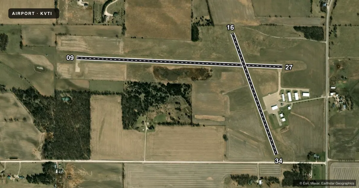
Airport sketch
Runways drawn to scale from FAA survey coordinates, rendered over satellite imagery. Not for navigation.
Approaches & charts
Services on the field
Fuel grades, oxygen, maintenance, ramp storage and lighting — as declared to the FAA by the airport operator.
Fuel & services
- Fuel
- 100LLAMOGAS
- Oxygen (bottled)
- Not available
- Oxygen (bulk)
- Not available
- Airframe repair
- Minor
- Power plant repair
- Minor
- Other services
- AGRI
Ramp & ground
- Transient storage
- Tie-down
- Landing fee
- No fee published
- Lighting schedule
- SEE RMK
- Beacon schedule
- SS-SR
- Beacon
- White / Green (civil land)(WG)
- Wind indicator
- Lighted
- Segmented circle
- No
Fuel & FBOs
Cheapest 100LL and Jet A on the field and nearby. Always confirm with the FBO before taxi.
Airport notes
Surface conditions, obstructions, local procedures, lighting outages and other notes published with each FAA cycle.
General notes
- RY 16/34 CLSD NIGHTS AND USED AS TWY FM RY 09/27 TO RAMP.
- WILDLIFE INVOF ARPT.
- FOR CD CTC CHICAGO ARTCC AT 630-906-8921.
Lighting notes
- PILOT CONTROLED MIRL RWY 09/27; TO ACTVT & ACTVT PAPI RWYS 09 & 27 AND REIL RWYS 09 & 27 - CTAF.
Fuel notes
- 100LLSELF SVC FUEL AVBL 24 HRS.
- ASELF SVC FUEL AVBL 24 HRS.
- MOGASSELF SVC FUEL AVBL 24 HRS.
Approach & departure obstructions
- 34RWY 34 APCH 18:1 AT DTHR.
Other notes
- THIS AIRPORT HAS BEEN SURVEYED BY THE NATIONAL GEODETIC SURVEY.
- MANAGERCHAIRMAN, ARPT CMSN. MGR NOT AT FIELD.
- AGRINOE AVIATION (319) 560-9363
VFR map & nearby airports
VFR sectional. Tap any ICAO chip to open that airport.
Key facts · KVTI
Answer card- ICAO
- KVTI
- Name
- VINTON VETERANS MEML AIRPARK
- Location
- VINTON, IOWA
- Elevation
- 842 ft MSL
- Traffic pattern altitude
- 1,842 ft MSL (1,000 AGL)
- Control tower
- Non-towered (use CTAF)
- Total runways
- 2
- Longest runway
- 09/27 · 4,000 ft
- Published ILS approaches
- 0
- Published frequencies
- 4
- Magnetic variation
- 1°
- Current flight rules
- VFR
- Current wind
- 160° at 8 kt
- Favored runway now
- RWY 16
Vinton Veterans Memorial Airpark sits in Vinton, Iowa. Field elevation is 842 ft MSL. The airport has two runways. The longest is runway 09/27 at 4,000 ft. Runway 16/34 is 2,500 ft. There is no control tower. Traffic uses CTAF 122.8. Cedar Rapids Approach and Departure are on 134.05 and 266.8.
No ILS approaches are published here. The pattern altitude is not published, so use standard 1,000 ft AGL unless the current Chart Supplement says otherwise. The on-field FBO is Vinton Veterans Memorial Airpark. It carries 100LL, Jet A Prist and MOGAS. Self-serve fuel is available 24 hours a day for those grades. Call (319) 560-9363 for current field info.
A few operational notes matter here. Wildlife is reported in the area, so keep a sharp scan on taxi, takeoff and landing. Runway 16/34 is closed at night. It is used as a taxiway from runway 09/27 to the ramp. Runway 34 also has an 18 to 1 approach slope at the displaced threshold. Pilot controlled medium intensity lights are available on runway 09/27. The PAPI and runway end identifier lights for 09 and 27 are also activated on CTAF. For clearance delivery, contact Chicago Center at 630-906-8921. The airport sits in a non-towered environment. Plan for standard self-announce traffic and watch for local pattern traffic.