METAR & TAF 8C6
8C6 does not publish a METAR.
Showing the nearest reporting station: KVTI (VINTON VETERANS MEML AIRPARK) · 19.2 NM away. Conditions at 8C6 may differ.
METAR · KVTI
Observed 03:55Z
KVTI 090355Z AUTO 16008KT 7SM RA SCT016 BKN043 OVC050 19/19 A3000 RMK AO2 P0086 T01920187
- Wind
- 160° @ 8 kt
- Visibility
- 7 SM
- Temp / Dew
- 19°C / 19°C
- Altimeter
- 30.00 inHg
- Clouds
- OVC
- Density alt
- 1,487 ft
- Ceiling
- 4,300 ft AGL
- Rules
- VFR
Airport info & contacts
Manager on record, flight service, ARTCC, attendance schedule and pattern altitude — published by the FAA and refreshed every 28 days.
Location
- From city
- 1 NM NE
- VFR sectional
- CHICAGO
- ARTCC
- ZMP · MINNEAPOLIS
- NOTAM facility
- FOD (NOTAM-D)
Airport manager
- Name
- PETE HOLDON
- Phone
- (319) 478-2580
- Address
- 649 2ND STREET, TRAER IA 50675
Flight service · Hours
- FSS FOD
- FORT DODGE1-800-WX-BRIEF
- Attendance
- Unattended
Frequencies
Tap any row to copy the frequency to your clipboard.
Runways & pattern
Full pagePattern entry · RWY 17
LEFT TRAFFICRunway end performance
| End | TORA | TODA | ASDA | LDA | VGSI | Approach lights | Obstruction |
|---|---|---|---|---|---|---|---|
| 17 | — | — | — | — | — | — | 70', trees, 806' from thr, 176' R of cntrln, slope 11 |
| 35 | — | — | — | — | — | — | 80', tree, 1689' from thr, 210' R of cntrln, slope 21 |
Declared distances in feet. TORA = takeoff run available, TODA = takeoff distance, ASDA = accelerate-stop, LDA = landing distance.
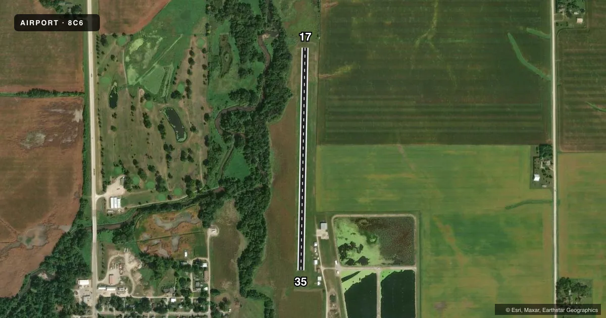
Airport sketch
Runways drawn to scale from FAA survey coordinates, rendered over satellite imagery. Not for navigation.
Approaches & charts
Services on the field
Fuel grades, oxygen, maintenance, ramp storage and lighting — as declared to the FAA by the airport operator.
Fuel & services
- Fuel
- Not available
- Oxygen (bottled)
- Not available
- Oxygen (bulk)
- Not available
- Airframe repair
- Not available
- Power plant repair
- Not available
Ramp & ground
- Transient storage
- Tie-down
- Landing fee
- No fee published
- Lighting schedule
- SS-SR
- Wind indicator
- Lighted
- Segmented circle
- No
Fuel & FBOs
Cheapest 100LL and Jet A on the field and nearby. Always confirm with the FBO before taxi.
Airport notes
Surface conditions, obstructions, local procedures, lighting outages and other notes published with each FAA cycle.
General notes
- SNOW RMVL DELAYED AT TIMES; CONFIRM RY COND PRIOR TO USE - CALL 319-478-2580
- TURF RY SOFT DURING SPRING THAW.
- PARALLEL TWY IS MKD AND LGTD ALONG EAST EDGE.
- MOGAS AND 100LL FUEL AVBL FOR EMERG ONLY; CALL 319-476-4353.
- FOR CD CTC DES MOINES APCH AT 515-974-8016. WHEN DES MOINES APP CLSD, FOR CD CTC MINNEAPOLIS ARTCC AT 651-463-5588.
Approach & departure obstructions
- 1717/35 MARKED WITH YELLOW CONES.
VFR map & nearby airports
VFR sectional. Tap any ICAO chip to open that airport.
Key facts · 8C6
Answer card- ICAO
- 8C6
- Name
- TRAER MUNI
- Location
- TRAER, IOWA
- Elevation
- 892 ft MSL
- Traffic pattern altitude
- 1,892 ft MSL (1,000 AGL)
- Control tower
- Non-towered (use CTAF)
- Total runways
- 1
- Longest runway
- 17/35 · 2,555 ft
- Published ILS approaches
- 0
- Published frequencies
- 1
- Magnetic variation
- 3°
- Current flight rules
- VFR
- Current wind
- 160° at 8 kt
- Favored runway now
- RWY 17
Traer Muni sits in Traer, Iowa. The field elevation is 892 ft MSL. It has one runway, 17/35, which is 2,555 ft of turf. The runway headings are 181° and 1° magnetic. There is no control tower. CTAF is 122.9. No ILS approaches are published here.
Pattern altitude is not published. Use the standard 1,000 ft AGL pattern unless the current Chart Supplement says otherwise. That puts the light aircraft pattern at 1,892 ft MSL based on the listed field elevation. For a first-time arrival, the main things to plan for are turf conditions and runway condition checks. The FAA remarks say the turf can be soft during spring thaw. Snow removal can also be delayed at times. Runway 17 and Runway 35 are marked with yellow cones. A marked and lighted parallel taxiway runs along the east edge.
No on-field FBOs are listed. The published remarks say mogas and 100LL are available for emergency only. Call ahead before you count on fuel. For clearance delivery, contact Des Moines Approach at 515-974-8016. When Des Moines Approach is closed, use Minneapolis ARTCC at 651-463-5588. Check the current Chart Supplement and call the airport operator before you go if you need current runway condition or operational details.