METAR & TAF 6K7
6K7 does not publish a METAR.
Showing the nearest reporting station: KMIW (MARSHALLTOWN MUNI) · 14.7 NM away. Conditions at 6K7 may differ.
METAR · KMIW
Observed 04:53Z
KMIW 270453Z AUTO 18007KT 10SM CLR 28/26 A2982 RMK AO2 SLP087 T02830261
- Wind
- 180° @ 7 kt
- Visibility
- 10 SM
- Temp / Dew
- 28°C / 26°C
- Altimeter
- 29.82 inHg
- Clouds
- CLR
- Density alt
- 3,017 ft
- Ceiling
- Unlimited
- Rules
- VFR
Airport info & contacts
Manager on record, flight service, ARTCC, attendance schedule and pattern altitude — published by the FAA and refreshed every 28 days.
Location
- From city
- 3 NM W
- VFR sectional
- CHICAGO
- ARTCC
- ZMP · MINNEAPOLIS
- NOTAM facility
- FOD (NOTAM-D)
Airport manager
- Name
- DAN BANGASSER
- Phone
- 319-825-6118
- Address
- 703 F AVENUE, SUITE 2, GRUNDY CENTER IA 50638
Flight service · Hours
- FSS FOD
- FORT DODGE1-800-WX-BRIEF
- Attendance
- Unattended
Frequencies
Tap any row to copy the frequency to your clipboard.
Runways & pattern
Full pagePattern entry · RWY 17
LEFT TRAFFICRunway end performance
| End | TORA | TODA | ASDA | LDA | VGSI | Approach lights | Obstruction |
|---|---|---|---|---|---|---|---|
| 35 | — | — | — | — | — | — | 4', fence, 0' from thr, 70' R of cntrln, slope 0 |
Declared distances in feet. TORA = takeoff run available, TODA = takeoff distance, ASDA = accelerate-stop, LDA = landing distance.
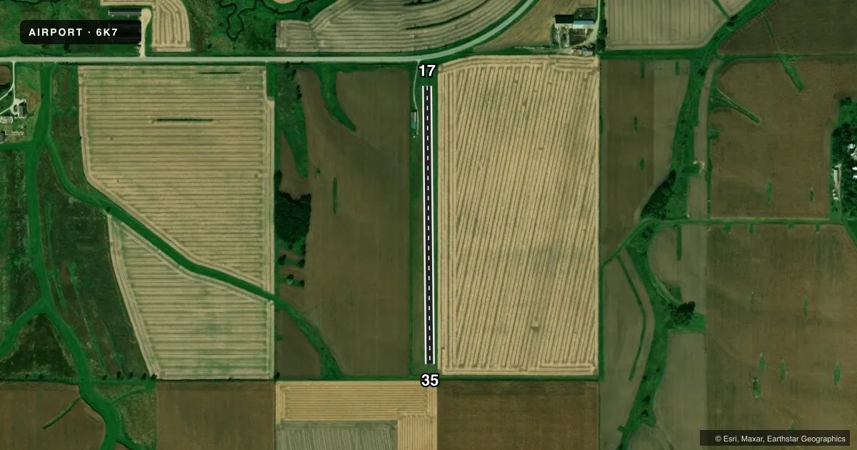
Airport sketch
Runways drawn to scale from FAA survey coordinates, rendered over satellite imagery. Not for navigation.
Approaches & charts
Services on the field
Fuel grades, oxygen, maintenance, ramp storage and lighting — as declared to the FAA by the airport operator.
Fuel & services
- Fuel
- Not available
- Oxygen (bottled)
- Not available
- Oxygen (bulk)
- Not available
- Airframe repair
- Not available
- Power plant repair
- Not available
Ramp & ground
- Transient storage
- Tie-down
- Landing fee
- No fee published
- Wind indicator
- No
- Segmented circle
- No
Fuel & FBOs
Cheapest 100LL and Jet A on the field and nearby. Always confirm with the FBO before taxi.
Airport notes
Surface conditions, obstructions, local procedures, lighting outages and other notes published with each FAA cycle.
General notes
- ARPT CLSD WINTER MONTHS.
- RADIO CONTROL ACFT ON AND AROUND ARPT.
- RY 17 +29 FT LGTD POLE 495 T FM DSPLCD THLD 155 FT R.
- (E98) T-HANGARS ADJACENT TO RWY.
- FOR CD CTC DES MOINES APCH AT 515-974-8016. WHEN DES MOINES APP CLSD, FOR CD CTC MINNEAPOLIS ARTCC AT 651-463-5588.
Approach & departure obstructions
- 17& 35 MARKED AT CORNERS & EDGES WITH YELLOW CONES.
- 17CONTROLLING OBSTN EXCEEDS A 45 DEG SLP.
VFR map & nearby airports
VFR sectional. Tap any ICAO chip to open that airport.
Key facts · 6K7
Answer card- ICAO
- 6K7
- Name
- GRUNDY CENTER MUNI
- Location
- GRUNDY CENTER, IOWA
- Elevation
- 1,075 ft MSL
- Traffic pattern altitude
- 2,075 ft MSL (1,000 AGL)
- Control tower
- Non-towered (use CTAF)
- Total runways
- 1
- Longest runway
- 17/35 · 2,250 ft
- Published ILS approaches
- 0
- Published frequencies
- 1
- Magnetic variation
- 3°
- Current flight rules
- VFR
- Current wind
- 180° at 7 kt
- Favored runway now
- RWY 17
Grundy Center Muni sits in Grundy Center, Iowa. Field elevation is 1,075 ft MSL. This is an uncontrolled airport with one runway. The longest runway is 17/35 at 2,250 ft. No ILS approaches are published. CTAF is 122.9.
The pattern altitude is not published in the facts. Use the standard 1,000 ft AGL pattern unless the current Chart Supplement says otherwise. That puts the light piston pattern near 2,075 ft MSL based on the field elevation, but confirm before you fly. The airport is closed during winter months, so check current status before planning an arrival.
Published remarks matter here. Radio control aircraft operate on and around the airport. T-hangars sit adjacent to the runway. Runway 17 has a lighted pole 495 ft from the displaced threshold on the right side. Runways 17 and 35 are marked with yellow cones at the corners and edges. There are no on-field FBOs listed, so contact the airport operator directly or call the field on CTAF for current service details. For clearance delivery, use Des Moines Approach at 515-974-8016. If that office is closed, Minneapolis ARTCC handles clearance delivery at 651-463-5588.