METAR & TAF 4C7
4C7 does not publish a METAR.
Showing the nearest reporting station: KIFA (IOWA FALLS MUNI) · 11.5 NM away. Conditions at 4C7 may differ.
METAR · KIFA
Observed 17:55Z
KIFA 241755Z AUTO 27007G14KT 10SM SCT045 SCT055 26/16 A3001 RMK AO2 T02640155 10265 20183
- Wind
- 270° @ 7G14 kt
- Visibility
- 10 SM
- Temp / Dew
- 26°C / 16°C
- Altimeter
- 30.01 inHg
- Clouds
- SCT
- Density alt
- 2,535 ft
- Ceiling
- Unlimited
- Rules
- VFR
Airport info & contacts
Manager on record, flight service, ARTCC, attendance schedule and pattern altitude — published by the FAA and refreshed every 28 days.
Location
- From city
- 1 NM SE
- VFR sectional
- OMAHA
- ARTCC
- ZMP · MINNEAPOLIS
- NOTAM facility
- FOD (NOTAM-D)
Airport manager
- Name
- DALE BRASS
- Phone
- 641-847-3395
- Address
- 1204 BUTLER STREET, ACKLEY IA 50601
Flight service · Hours
- FSS FOD
- FORT DODGE1-800-WX-BRIEF
- Attendance
- Unattended
Frequencies
Tap any row to copy the frequency to your clipboard.
Runways & pattern
Full pagePattern entry · RWY 33
LEFT TRAFFICRunway end performance
| End | TORA | TODA | ASDA | LDA | VGSI | Approach lights | Obstruction |
|---|---|---|---|---|---|---|---|
| 33 | — | — | — | — | — | — | 15', road, 200' from thr, 125' R of cntrln, slope 13 |
Declared distances in feet. TORA = takeoff run available, TODA = takeoff distance, ASDA = accelerate-stop, LDA = landing distance.
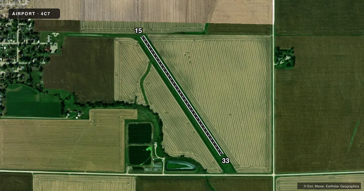
Airport sketch
Runways drawn to scale from FAA survey coordinates, rendered over satellite imagery. Not for navigation.
Approaches & charts
Services on the field
Fuel grades, oxygen, maintenance, ramp storage and lighting — as declared to the FAA by the airport operator.
Fuel & services
- Fuel
- Not available
- Oxygen (bottled)
- Not available
- Oxygen (bulk)
- Not available
- Airframe repair
- Not available
- Power plant repair
- Not available
Ramp & ground
- Transient storage
- Tie-down
- Hangar
- Landing fee
- No fee published
- Wind indicator
- Yes
- Segmented circle
- No
Fuel & FBOs
Cheapest 100LL and Jet A on the field and nearby. Always confirm with the FBO before taxi.
Airport notes
Surface conditions, obstructions, local procedures, lighting outages and other notes published with each FAA cycle.
General notes
- NO SNOW REMOVAL. ARPT CLSD WHEN SNOW CONDITIONS EXIST.
- RADIO CONTROLLED AIRCRAFT ACTIVITY.
- SEASONAL AG ACFT OPERATIONS.
- FOR CD CTC DES MOINES APCH AT 515-974-8016. WHEN DES MOINES APP CLSD, FOR CD CTC MINNEAPOLIS ARTCC AT 651-463-5588.
Other notes
- MANAGERCELL NUMBER 641-751-4666
VFR map & nearby airports
VFR sectional. Tap any ICAO chip to open that airport.
Key facts · 4C7
Answer card- ICAO
- 4C7
- Name
- ACKLEY MUNI
- Location
- ACKLEY, IOWA
- Elevation
- 1,070 ft MSL
- Traffic pattern altitude
- 2,070 ft MSL (1,000 AGL)
- Control tower
- Non-towered (use CTAF)
- Total runways
- 1
- Longest runway
- 15/33 · 2,725 ft
- Published ILS approaches
- 0
- Published frequencies
- 1
- Magnetic variation
- 3°
- Current flight rules
- VFR
- Current wind
- 270° at 7 kt
- Favored runway now
- RWY 33
Ackley Muni sits in Ackley, Iowa. Field elevation is 1,070 ft MSL. The airport has one runway. Runway 15/33 is 2,725 ft of turf, which is the longest runway on the field. No control tower is listed, so use CTAF 122.9 for local traffic calls.
No ILS approaches are published here. Pattern altitude is not published in the facts, so use standard pattern planning only after checking the current FAA Chart Supplement. The airport remarks also note seasonal agricultural aircraft operations. Radio controlled aircraft activity occurs here too. Snow removal is not provided. The field is closed when snow conditions exist.
For clearance delivery, contact Des Moines Approach at 515-974-8016. When Des Moines Approach is closed, contact Minneapolis ARTCC at 651-463-5588. There are no on-field FBOs listed in the facts, so call the airport operator directly before arrival if you need services. The manager’s cell number is 641-751-4666. For a first-time visit, plan for a small turf strip with no published precision approach support and verify current field conditions before you go.