METAR & TAF KHPT
Current METAR
Observed 13:35Z
KHPT 271335Z AUTO 22008KT 10SM CLR 27/25 A2976 RMK AO2
- Wind
- 220° @ 8 kt
- Visibility
- 10 SM
- Temp / Dew
- 27°C / 25°C
- Altimeter
- 29.76 inHg
- Clouds
- CLR
- Density alt
- 3,097 ft
- Ceiling
- Unlimited
- Rules
- VFR
Airport info & contacts
Manager on record, flight service, ARTCC, attendance schedule and pattern altitude — published by the FAA and refreshed every 28 days.
Location
- From city
- 2 NM SW
- VFR sectional
- OMAHA
- ARTCC
- ZMP · MINNEAPOLIS
- NOTAM facility
- FOD (NOTAM-D)
Airport manager
- Name
- JAY SCHUMANN
- Phone
- 641-456-4102
- Address
- 1274 B OLIVE AVE, HAMPTON IA 50441
Flight service · Hours
- FSS FOD
- FORT DODGE1-800-WX-BRIEF
- Attendance
- MON-FRI · 0800-1700
Frequencies
Tap any row to copy the frequency to your clipboard.
Runways & pattern
Full pagePattern entry · RWY 17
LEFT TRAFFICRunway end performance
| End | TORA | TODA | ASDA | LDA | VGSI | Approach lights | Obstruction |
|---|---|---|---|---|---|---|---|
| 17 | — | — | — | — | PAPI 2-box left(3°) | — | — |
| 35 | — | — | — | — | PAPI 2-box left(3°) | — | — |
Declared distances in feet. TORA = takeoff run available, TODA = takeoff distance, ASDA = accelerate-stop, LDA = landing distance.
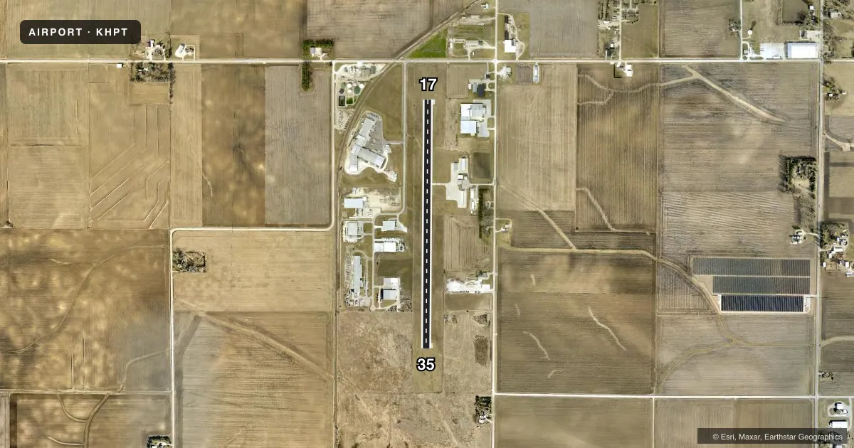
Airport sketch
Runways drawn to scale from FAA survey coordinates, rendered over satellite imagery. Not for navigation.
Approaches & charts
Services on the field
Fuel grades, oxygen, maintenance, ramp storage and lighting — as declared to the FAA by the airport operator.
Fuel & services
- Fuel
- 100LLA
- Oxygen (bottled)
- Not available
- Oxygen (bulk)
- Not available
- Airframe repair
- Minor
- Power plant repair
- Minor
Ramp & ground
- Transient storage
- Tie-down
- Hangar
- Landing fee
- No fee published
- Customs
- Not available
- Lighting schedule
- SEE RMK
- Beacon schedule
- SS-SR
- Beacon
- White / Green (civil land)(WG)
- Wind indicator
- Lighted
- Segmented circle
- No
Fuel & FBOs
Cheapest 100LL and Jet A on the field and nearby. Always confirm with the FBO before taxi.
Airport notes
Surface conditions, obstructions, local procedures, lighting outages and other notes published with each FAA cycle.
General notes
- FOR CD CTC MINNEAPOLIS ARTCC AT 651-463-5588.
Lighting notes
- ACTVT REIL RWY 17 & 35; PAPI RWY 17 & 35; MIRL RWY 17/35 - CTAF.
Other notes
- 1FOR ATTENDANT AFT HRS CALL 641-456-9000 OR 641-456-2529 (POLICE DEPT.)
- MANAGERSCHUMANN AVIATION
VFR map & nearby airports
VFR sectional. Tap any ICAO chip to open that airport.
Key facts · KHPT
Answer card- ICAO
- KHPT
- Name
- HAMPTON MUNI
- Location
- HAMPTON, IOWA
- Elevation
- 1,176.3 ft MSL
- Traffic pattern altitude
- 2,176.3 ft MSL (1,000 AGL)
- Control tower
- Non-towered (use CTAF)
- Total runways
- 1
- Longest runway
- 17/35 · 4,020 ft
- Published ILS approaches
- 0
- Published frequencies
- 2
- Magnetic variation
- 3°
- Current flight rules
- VFR
- Current wind
- 220° at 8 kt
- Favored runway now
- RWY 17
Hampton Muni sits in Hampton, Iowa. Field elevation is 1,176.3 ft MSL. The airport has one runway, 17/35, which is 4,020 ft long and paved with concrete. There is no control tower. Use CTAF 122.7 for local traffic. UNICOM is also 122.7.
No ILS approaches are published here. The published pattern altitude is not listed. Plan on the standard 1,000 ft AGL unless the current Chart Supplement says otherwise. That puts you at about 2,176.3 ft MSL on a normal piston pattern. Runway 17 and 35 have runway end identifier lights, precision approach path indicators and medium intensity runway lighting. That helps for night work and for getting stabilized on final.
Schumann Aviation is on the field. It carries 100LL. The airport manager is Schumann Aviation. For clearance delivery, contact Minneapolis ARTCC at 651-463-5588. If you need an attendant after hours, call 641-456-9000 or the police department at 641-456-2529. This is a non-towered field at moderate elevation, so expect normal Midwest density altitude planning on warm days. Check the current Chart Supplement for any published noise or curfew restrictions before flying into the field.