METAR & TAF KIFA
Current METAR
Observed 18:55Z
KIFA 271855Z AUTO 32007KT 10SM CLR 35/27 A2977 RMK AO2 T03450272
- Wind
- 320° @ 7 kt
- Visibility
- 10 SM
- Temp / Dew
- 35°C / 27°C
- Altimeter
- 29.77 inHg
- Clouds
- CLR
- Density alt
- 3,996 ft
- Ceiling
- Unlimited
- Rules
- VFR
Airport info & contacts
Manager on record, flight service, ARTCC, attendance schedule and pattern altitude — published by the FAA and refreshed every 28 days.
Location
- From city
- 3 NM S
- VFR sectional
- OMAHA
- ARTCC
- ZMP · MINNEAPOLIS
- NOTAM facility
- IFA (NOTAM-D)
Airport manager
- Name
- RENA HEEM
- Phone
- 515-290-5450
- Address
- 16041 HWY 65, IOWA FALLS IA 50126-8443
Flight service · Hours
- FSS FOD
- FORT DODGE1-800-WX-BRIEF
- Attendance
- MON-FRI · 0800-1700
Frequencies
Tap any row to copy the frequency to your clipboard.
Runways & pattern
Full pagePattern entry · RWY 31
LEFT TRAFFICRunway end performance
| End | TORA | TODA | ASDA | LDA | VGSI | Approach lights | Obstruction |
|---|---|---|---|---|---|---|---|
| 13 | — | — | — | — | PAPI 2-box left(3°) | — | — |
| 31 | — | — | — | — | PAPI 2-box left(3°) | — | — |
Declared distances in feet. TORA = takeoff run available, TODA = takeoff distance, ASDA = accelerate-stop, LDA = landing distance.
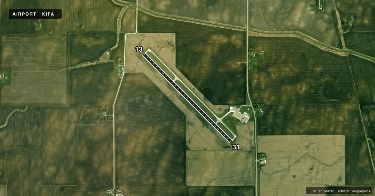
Airport sketch
Runways drawn to scale from FAA survey coordinates, rendered over satellite imagery. Not for navigation.
Approaches & charts
Services on the field
Fuel grades, oxygen, maintenance, ramp storage and lighting — as declared to the FAA by the airport operator.
Fuel & services
- Fuel
- 100LLA+
- Oxygen (bottled)
- Not available
- Oxygen (bulk)
- Not available
- Airframe repair
- Not available
- Power plant repair
- Not available
- Other services
- AGRI
Ramp & ground
- Transient storage
- Tie-down
- Hangar
- Landing fee
- No fee published
- Customs
- Not available
- Lighting schedule
- SEE RMK
- Beacon schedule
- SS-SR
- Beacon
- White / Green (civil land)(WG)
- Wind indicator
- Lighted
- Segmented circle
- No
Fuel & FBOs
Cheapest 100LL and Jet A on the field and nearby. Always confirm with the FBO before taxi.
Airport notes
Surface conditions, obstructions, local procedures, lighting outages and other notes published with each FAA cycle.
General notes
- RY 31 IS CALM WIND RY.
- FOR CD CTC DES MOINES APCH AT 515-974-8016. WHEN DES MOINES APP CLSD, FOR CD CTC MINNEAPOLIS ARTCC AT 651-463-5588.
Lighting notes
- ACTVT MIRL RY 13/31; REIL & PAPI RYS 13 & 31 - CTAF.
Fuel notes
- 100LL24 HOUR SELF SERVE FUEL AVAILABLE
VFR map & nearby airports
VFR sectional. Tap any ICAO chip to open that airport.
Key facts · KIFA
Answer card- ICAO
- KIFA
- Name
- IOWA FALLS MUNI
- Location
- IOWA FALLS, IOWA
- Elevation
- 1,137.4 ft MSL
- Traffic pattern altitude
- 2,137.4 ft MSL (1,000 AGL)
- Control tower
- Non-towered (use CTAF)
- Total runways
- 1
- Longest runway
- 13/31 · 4,602 ft
- Published ILS approaches
- 0
- Published frequencies
- 4
- Magnetic variation
- 1°
- Current flight rules
- VFR
- Current wind
- 320° at 7 kt
- Favored runway now
- RWY 31
Iowa Falls Muni sits in Iowa Falls, Iowa. The field elevation is 1,137.4 ft MSL. It has one runway, 13/31, which is 4,602 ft long. There is no control tower. Pattern altitude is not published, so use the standard 1,000 ft AGL unless the current Chart Supplement says otherwise.
No ILS approaches are published here. Runway 13/31 has medium intensity lighting. Runway end identifier lights and PAPI are installed on both ends. They are controlled by CTAF. Runway 31 is listed as the calm wind runway. For clearance delivery, Des Moines Approach is the first call. When Des Moines Approach is closed, Minneapolis ARTCC handles clearance delivery.
Iowa Falls Municipal Airport is on the field. It carries 100LL and Jet A with Prist availability. 24-hour self-serve 100LL is available. CTAF and UNICOM are both 122.8. The airport sits in uncontrolled airspace from the tower standpoint, so plan your arrival. Self-announce clearly. Expect local traffic to work the pattern on CTAF. If you are flying in at night or in marginal weather, check the current Chart Supplement and coordinate with the airport operator or the FBO directly for the latest field status.