METAR & TAF KEBS
Current METAR
Observed 20:15Z
KEBS 272015Z AUTO RMK AO2 PNO PWINO
- Wind
- Calm
- Visibility
- —
- Temp / Dew
- —
- Altimeter
- —
- Clouds
- Clear
- Density alt
- —
- Ceiling
- Unlimited
- Rules
- VFR
Airport info & contacts
Manager on record, flight service, ARTCC, attendance schedule and pattern altitude — published by the FAA and refreshed every 28 days.
Location
- From city
- 3 NM SW
- VFR sectional
- OMAHA
- ARTCC
- ZMP · MINNEAPOLIS
- NOTAM facility
- EBS (NOTAM-D)
Airport manager
- Name
- MIKE LUEDTKE
- Phone
- 515-832-3723
- Address
- 1524 - 240TH ST, WEBSTER CITY IA 50595
Flight service · Hours
- FSS FOD
- FORT DODGE1-800-WX-BRIEF
- Attendance
- MON-FRI · 0800-1700
- SAT-SUN · ON CALL
Frequencies
Tap any row to copy the frequency to your clipboard.
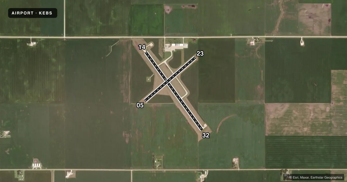
Runways & pattern
Full pagePattern entry · RWY 14
LEFT TRAFFIC| Runway | Heading (°M) | Length | Surface | Traffic |
|---|---|---|---|---|
| 14/32 | 141° / 321° | 3,851 ft | CONC | Standard L |
| 05/23 | 46° / 226° | 2,663 ft | TURF | Standard L |
Runway end performance
| End | TORA | TODA | ASDA | LDA | VGSI | Approach lights | Obstruction |
|---|---|---|---|---|---|---|---|
| 14 | — | — | — | — | PAPI 4-box left(3°) | — | 19', road, 503' from thr, 290' R of cntrln, slope 15 |
| 32 | — | — | — | — | PAPI 4-box left(3°) | — | — |
| 05 | — | — | — | — | — | — | 6', crops, 210' from thr, 45' R of cntrln, slope 35 |
Declared distances in feet. TORA = takeoff run available, TODA = takeoff distance, ASDA = accelerate-stop, LDA = landing distance.
Airport sketch
Runways drawn to scale from FAA survey coordinates, rendered over satellite imagery. Not for navigation.
Approaches & charts
Services on the field
Fuel grades, oxygen, maintenance, ramp storage and lighting — as declared to the FAA by the airport operator.
Fuel & services
- Fuel
- 100LLA
- Oxygen (bottled)
- Not available
- Oxygen (bulk)
- Not available
- Airframe repair
- Major
- Power plant repair
- Major
- Other services
- AGRI,CHTR,INSTR,RNTL,SALES
Ramp & ground
- Transient storage
- Tie-down
- Hangar
- Landing fee
- No fee published
- Customs
- Not available
- Lighting schedule
- SEE RMK
- Beacon schedule
- SS-SR
- Beacon
- White / Green (civil land)(WG)
- Wind indicator
- Lighted
- Segmented circle
- No
Fuel & FBOs
Cheapest 100LL and Jet A on the field and nearby. Always confirm with the FBO before taxi.
Airport notes
Surface conditions, obstructions, local procedures, lighting outages and other notes published with each FAA cycle.
General notes
- FOR CD CTC MINNEAPOLIS ARTCC AT 651-463-5588.
Lighting notes
- ACTVT REIL RWY 14 & 32; PAPI RWY 14 & 32; MIRL RWY 14/32 - CTAF.
Runway surface & condition
- 05/23CLSD NOV-APR.
Approach & departure obstructions
- 0505/23 THRS & EDGES MKD WITH CONES.
Other notes
- CONDL-PRVD THE APCH TO EACH RWY IS MAINTAINED FOR A MINIMUM 20:1 GLIDE SLOPE AND THE TRANSITIONAL SURFACE BE MAINTAINED FOR A 7:1 SLOPE.
- 2ON CALL MON-FRI AFT HRS AND ALL DAY SAT & SUN 515-832-3723.
- MANAGEREMAIL ADDRESS: INFO@STORMFLYINGSERVICE.COM
- OWNERCHAIRMAN ARPT CMSN SCOTT BARGFREDE
VFR map & nearby airports
VFR sectional. Tap any ICAO chip to open that airport.
Key facts · KEBS
Answer card- ICAO
- KEBS
- Name
- WEBSTER CITY MUNI
- Location
- WEBSTER CITY, IOWA
- Elevation
- 1,121.5 ft MSL
- Traffic pattern altitude
- 2,121.5 ft MSL (1,000 AGL)
- Control tower
- Non-towered (use CTAF)
- Total runways
- 2
- Longest runway
- 14/32 · 3,851 ft
- Published ILS approaches
- 0
- Published frequencies
- 2
- Magnetic variation
- 3°
- Current flight rules
- VFR
- Current wind
- Calm / unavailable
- Favored runway now
- –
Webster City Muni sits in Webster City, Iowa. The field elevation is 1,121.5 ft MSL. It has two runways. The longest is runway 14/32 at 3,851 ft. There is no control tower. CTAF and UNICOM are both 122.8. No ILS approaches are published.
The pattern altitude is not published. Use the standard 1,000 ft AGL for light piston operations unless the current Chart Supplement says otherwise. Storm Flying Service is on the field. It carries 100LL and Jet A. Call 515-832-3723 for airport services after hours on weekdays or any time on weekends. The remarks also note that runway 05/23 is closed from November through April. That matters for planning. Runway 05/23 is the turf runway. Its thresholds and edges are marked with cones.
For a first visit, pay attention to the runway lighting setup on 14/32. The runway end identifier lights, PAPI and medium intensity runway lights are activated by CTAF. The published remarks also call out approach and transitional surface slope protection around the airport. This is a small non-towered field with one paved runway and one turf runway. Check the current Chart Supplement for any local procedures before you go.