METAR & TAF 0K7
0K7 does not publish a METAR.
Showing the nearest reporting station: KFOD (FORT DODGE RGNL) · 11.3 NM away. Conditions at 0K7 may differ.
METAR · KFOD
Observed 12:56Z
KFOD 271256Z AUTO 24004KT 10SM CLR 27/24 A2978 RMK AO2 SLP084 T02720244 $
- Wind
- 240° @ 4 kt
- Visibility
- 10 SM
- Temp / Dew
- 27°C / 24°C
- Altimeter
- 29.78 inHg
- Clouds
- CLR
- Density alt
- 2,975 ft
- Ceiling
- Unlimited
- Rules
- VFR
Airport info & contacts
Manager on record, flight service, ARTCC, attendance schedule and pattern altitude — published by the FAA and refreshed every 28 days.
Location
- From city
- 1 NM W
- VFR sectional
- OMAHA
- ARTCC
- ZMP · MINNEAPOLIS
- NOTAM facility
- FOD (NOTAM-D)
Airport manager
- Name
- FLETCHER SATERN
- Phone
- 515-368-4505
- Address
- 309 4TH STREET SOUTH, DAKOTA CITY IA 50529
Flight service · Hours
- FSS FOD
- FORT DODGE1-800-WX-BRIEF
- Attendance
- Unattended
Frequencies
Tap any row to copy the frequency to your clipboard.
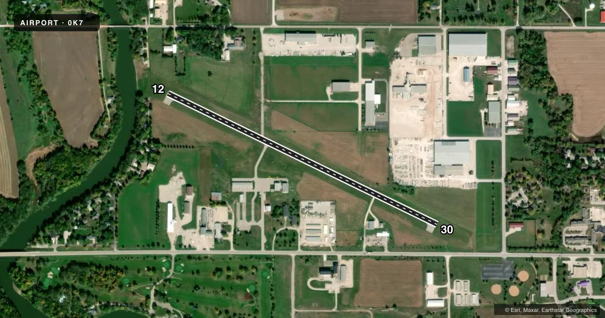
Runways & pattern
Full pagePattern entry · RWY 30
LEFT TRAFFICRunway end performance
| End | TORA | TODA | ASDA | LDA | VGSI | Approach lights | Obstruction |
|---|---|---|---|---|---|---|---|
| 12 | — | — | — | — | PAPI 2-box left(3°) | — | 47', tree, 484' from thr, 169' R of cntrln, slope 6 |
| 30 | — | — | — | — | PAPI 2-box left(3°) | — | 58', tree, 1174' from thr, 100' R of cntrln, slope 16 |
Declared distances in feet. TORA = takeoff run available, TODA = takeoff distance, ASDA = accelerate-stop, LDA = landing distance.
Airport sketch
Runways drawn to scale from FAA survey coordinates, rendered over satellite imagery. Not for navigation.
Approaches & charts
Services on the field
Fuel grades, oxygen, maintenance, ramp storage and lighting — as declared to the FAA by the airport operator.
Fuel & services
- Fuel
- 100LL
- Oxygen (bottled)
- Not available
- Oxygen (bulk)
- Not available
- Airframe repair
- Not available
- Power plant repair
- Not available
Ramp & ground
- Transient storage
- Tie-down
- Hangar
- Landing fee
- No fee published
- Customs
- Not available
- Lighting schedule
- SEE RMK
- Beacon schedule
- SS-SR
- Beacon
- White(W)
- Wind indicator
- Lighted
- Segmented circle
- No
Fuel & FBOs
Cheapest 100LL and Jet A on the field and nearby. Always confirm with the FBO before taxi.
Airport notes
Surface conditions, obstructions, local procedures, lighting outages and other notes published with each FAA cycle.
General notes
- <RDO TWR 1340' MSL 5125' E ARPT PENTS CONICAL SFC APRX 85'.
- MIGRATORY BIRD HAZARD ON & INVOF ARPT.
- FOR CD CTC MINNEAPOLIS ARTCC AT 651-463-5588.
Lighting notes
- DUSK-DAWN. RY LGTS ON LOW INTST DUSK-DAWN.
Fuel notes
- 100LLSELF SERVICE CREDIT CARD FUEL.
Approach & departure obstructions
- 30REIL OTS INDEFLY.
Other notes
- 1FOR SVC AFT HRS CALL (515) 332-4215 (AIRPORT MANAGER).
VFR map & nearby airports
VFR sectional. Tap any ICAO chip to open that airport.
Key facts · 0K7
Answer card- ICAO
- 0K7
- Name
- HUMBOLDT MUNI
- Location
- HUMBOLDT, IOWA
- Elevation
- 1,098.3 ft MSL
- Traffic pattern altitude
- 2,098.3 ft MSL (1,000 AGL)
- Control tower
- Non-towered (use CTAF)
- Total runways
- 1
- Longest runway
- 12/30 · 3,417 ft
- Published ILS approaches
- 0
- Published frequencies
- 2
- Magnetic variation
- 4°
- Current flight rules
- VFR
- Current wind
- 240° at 4 kt
- Favored runway now
- RWY 30
Humboldt Muni sits in Humboldt, Iowa. The field elevation is 1,098.3 ft MSL. It has one runway. Runway 12/30 is 3,417 ft of asphalt, so plan performance with that length in mind. There is no control tower. CTAF and UNICOM are both 122.8. No ILS approaches are published here.
The pattern altitude is not published. For light piston operations, use the standard 1,000 ft AGL unless the current Chart Supplement or local procedures say otherwise. The on-field FBO is Humboldt Municipal Airport. It carries 100LL. Self-service credit card fuel is available. For service after hours, call the airport manager.
A few operational items matter here. There is a migratory bird hazard on and near the airport. Runway lights are low intensity from dusk to dawn. Runway end identifier lights on runway 30 are out of service indefinitely. There is also a radio tower east of the airport that penetrates the conical surface. If you are planning a night arrival or a first visit, review the current Chart Supplement and brief the lighting and obstacle picture before you go. Clearance delivery is handled through Minneapolis ARTCC.