METAR & TAF KPOH
KPOH does not publish a METAR.
Showing the nearest reporting station: KFOD (FORT DODGE RGNL) · 23.2 NM away. Conditions at KPOH may differ.
METAR · KFOD
Observed 21:56Z
KFOD 272156Z AUTO 32004KT 10SM CLR 33/22 A2979 RMK AO2 SLP087 T03280222 $
- Wind
- 320° @ 4 kt
- Visibility
- 10 SM
- Temp / Dew
- 33°C / 22°C
- Altimeter
- 29.79 inHg
- Clouds
- CLR
- Density alt
- 3,841 ft
- Ceiling
- Unlimited
- Rules
- VFR
Airport info & contacts
Manager on record, flight service, ARTCC, attendance schedule and pattern altitude — published by the FAA and refreshed every 28 days.
Location
- From city
- 1 NM NE
- VFR sectional
- OMAHA
- ARTCC
- ZMP · MINNEAPOLIS
- NOTAM facility
- FOD (NOTAM-D)
Airport manager
- Name
- DENNIS DAHL
- Phone
- 712-335-4236
- Address
- 212 SOUTH MAIN, POCAHONTAS IA 50574
Flight service · Hours
- FSS FOD
- FORT DODGE1-800-WX-BRIEF
- Attendance
- Unattended
Frequencies
Tap any row to copy the frequency to your clipboard.
Runways & pattern
Full pagePattern entry · RWY 30
LEFT TRAFFIC| Runway | Heading (°M) | Length | Surface | Traffic |
|---|---|---|---|---|
| 12/30Favored | 119° / 299° | 4,100 ft | ASPH | Standard L |
| 18/36 | 182° / 2° | 1,999 ft | TURF | Standard L |
Runway end performance
| End | TORA | TODA | ASDA | LDA | VGSI | Approach lights | Obstruction |
|---|---|---|---|---|---|---|---|
| 12 | — | — | — | — | PAPI 2-box left(3°) | — | 62', tree, 915' from thr, 355' R of cntrln, slope 11 |
| 30 | — | — | — | — | PAPI 2-box left(3°) | — | 15', road, 545' from thr, 260' R of cntrln, slope 23 |
| 18 | — | — | — | — | — | — | 19', road, 405' from thr, 0' R of cntrln, slope 21 |
Declared distances in feet. TORA = takeoff run available, TODA = takeoff distance, ASDA = accelerate-stop, LDA = landing distance.
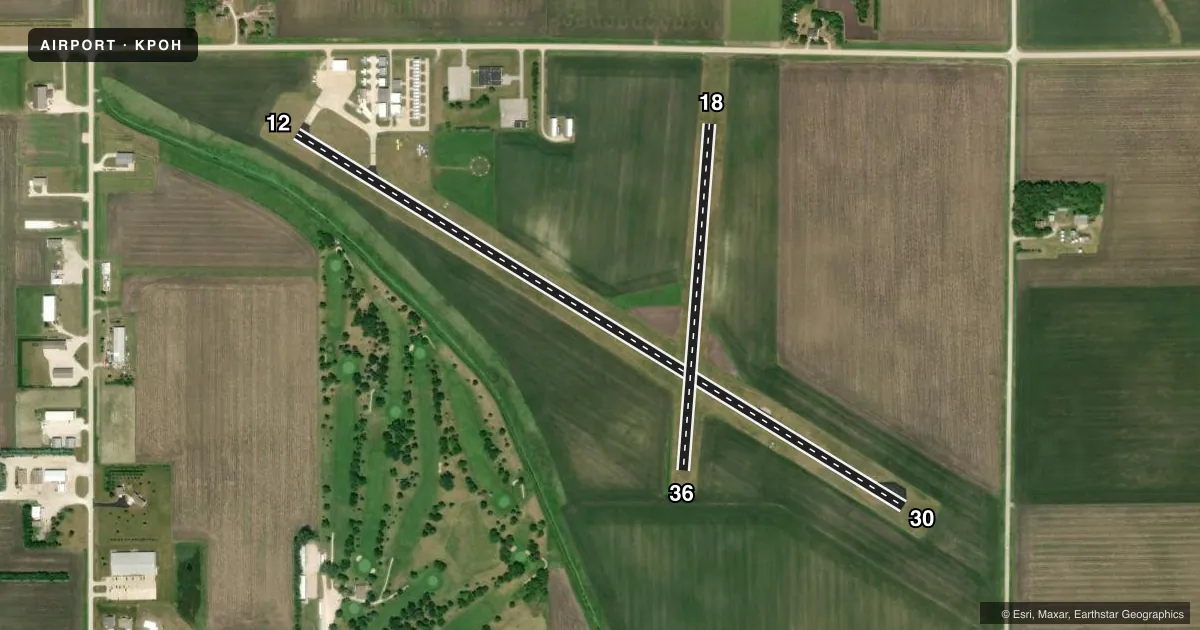
Airport sketch
Runways drawn to scale from FAA survey coordinates, rendered over satellite imagery. Not for navigation.
Approaches & charts
Services on the field
Fuel grades, oxygen, maintenance, ramp storage and lighting — as declared to the FAA by the airport operator.
Fuel & services
- Fuel
- 100LL
- Other services
- AGRI,INSTR,RNTL
Ramp & ground
- Transient storage
- Tie-down
- Hangar
- Landing fee
- No fee published
- Customs
- Not available
- Lighting schedule
- SEE RMK
- Beacon schedule
- SS-SR
- Beacon
- White / Green (civil land)(WG)
- Wind indicator
- Lighted
- Segmented circle
- Yes
Fuel & FBOs
Cheapest 100LL and Jet A on the field and nearby. Always confirm with the FBO before taxi.
Airport notes
Surface conditions, obstructions, local procedures, lighting outages and other notes published with each FAA cycle.
General notes
- FOR CD CTC MINNEAPOLIS ARTCC AT 651-463-5588.
Lighting notes
- ACTVT REIL RWY 12 & 30; PAPI RWY 12 & 30; MIRL RWY 12/30 - CTAF.
Runway surface & condition
- 12/30RWY 30 CALM WIND RWY.
- 18/36NO SNOW REMOVAL, RWY CLSD WHEN SNOW CONDITIONS EXIST.
Approach & departure obstructions
- 18YELLOW CONES.
- 36YELLOW CONES.
Other notes
- 1FOR SVC CALL SHERIFFS OFFICE (712) 335-3308.
- MANAGEROFFICE NUMBER 712-335-4382
VFR map & nearby airports
VFR sectional. Tap any ICAO chip to open that airport.
Key facts · KPOH
Answer card- ICAO
- KPOH
- Name
- POCAHONTAS MUNI
- Location
- POCAHONTAS, IOWA
- Elevation
- 1,225.5 ft MSL
- Traffic pattern altitude
- 2,225.5 ft MSL (1,000 AGL)
- Control tower
- Non-towered (use CTAF)
- Total runways
- 2
- Longest runway
- 12/30 · 4,100 ft
- Published ILS approaches
- 0
- Published frequencies
- 2
- Magnetic variation
- 2°
- Current flight rules
- VFR
- Current wind
- 320° at 4 kt
- Favored runway now
- RWY 30
Pocahontas Muni is in Pocahontas, Iowa. The field elevation is 1,225.5 ft MSL. It has two runways. The longest is 12/30 at 4,100 ft of asphalt. Runway 18/36 is 1,999 ft of turf. There is no control tower. CTAF and UNICOM are both 122.8.
No ILS approaches are published here. The pattern altitude is not published, so use 1,000 ft AGL for light piston operations unless the current Chart Supplement says otherwise. Runway 12 and 30 have runway end identifier lights, precision approach path indicators and medium intensity runway lights. Runway 30 is the calm wind runway. That is the runway to expect when winds are light.
Pocahontas Municipal Airport is the on-field FBO. It carries 100LL. Call the field at (712) 335-4841 for current service details. The manager's office number is 712-335-4382. For service, the sheriff's office number is 712-335-3308. There is no snow removal on runway 18/36. That runway is closed when snow conditions exist. Yellow cones mark the ends of runways 18 and 36.
This is a non-towered field with a single paved runway that will handle most local piston traffic. Check the current Chart Supplement for any published restrictions before you go. If you need clearance delivery, Minneapolis ARTCC can be reached at 651-463-5588.