METAR & TAF KEGQ
KEGQ does not publish a METAR.
Showing the nearest reporting station: KEST (ESTHERVILLE MUNI) · 18.3 NM away. Conditions at KEGQ may differ.
METAR · KEST
Observed 16:49Z
KEST 271649Z AUTO 36006KT 10SM CLR 29/22 A2981 RMK AO2 SLP081 T02890222
- Wind
- 360° @ 6 kt
- Visibility
- 10 SM
- Temp / Dew
- 29°C / 22°C
- Altimeter
- 29.81 inHg
- Clouds
- CLR
- Density alt
- 3,312 ft
- Ceiling
- Unlimited
- Rules
- VFR
Airport info & contacts
Manager on record, flight service, ARTCC, attendance schedule and pattern altitude — published by the FAA and refreshed every 28 days.
Location
- From city
- 1 NM SW
- VFR sectional
- OMAHA
- ARTCC
- ZMP · MINNEAPOLIS
- NOTAM facility
- FOD (NOTAM-D)
Airport manager
- Name
- KIMBERLY KIBBIE
- Phone
- 712-852-4030
- Address
- 3775 450TH STREET, EMMETSBURG IA 50536
Flight service · Hours
- FSS FOD
- FORT DODGE1-800-WX-BRIEF
- Attendance
- IRREGULAR
Frequencies
Tap any row to copy the frequency to your clipboard.
Runways & pattern
Full pagePattern entry · RWY 31
LEFT TRAFFICRunway end performance
| End | TORA | TODA | ASDA | LDA | VGSI | Approach lights | Obstruction |
|---|---|---|---|---|---|---|---|
| 13 | — | — | — | — | PAPI 4-box left(4°) | — | 55', trees, 434' from thr, 224' R of cntrln, slope 4 |
| 31 | — | — | — | — | PAPI 4-box left(3°) | — | 62', tree, 1371' from thr, 328' R of cntrln, slope 18 |
Declared distances in feet. TORA = takeoff run available, TODA = takeoff distance, ASDA = accelerate-stop, LDA = landing distance.
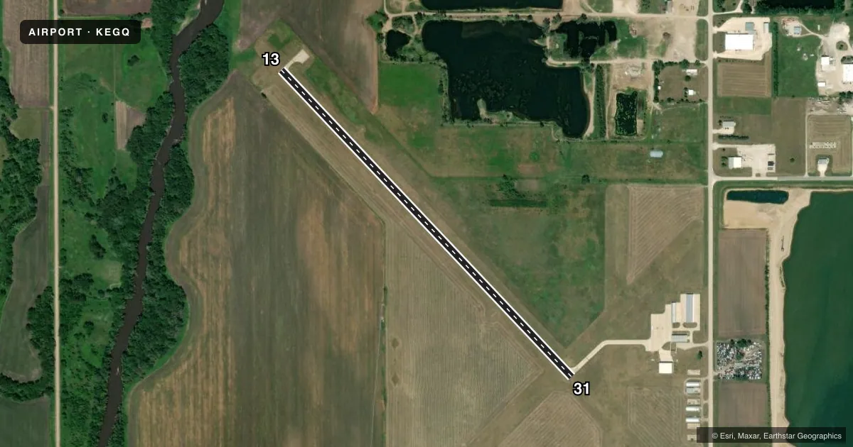
Airport sketch
Runways drawn to scale from FAA survey coordinates, rendered over satellite imagery. Not for navigation.
Approaches & charts
Services on the field
Fuel grades, oxygen, maintenance, ramp storage and lighting — as declared to the FAA by the airport operator.
Fuel & services
- Fuel
- 100LL
- Oxygen (bottled)
- Not available
- Oxygen (bulk)
- Not available
- Airframe repair
- Not available
- Power plant repair
- Not available
- Other services
- AGRI
Ramp & ground
- Transient storage
- Tie-down
- Hangar
- Landing fee
- No fee published
- Customs
- Not available
- Lighting schedule
- SEE RMK
- Beacon schedule
- SS-SR
- Beacon
- White / Green (civil land)(WG)
- Wind indicator
- Lighted
- Segmented circle
- No
Fuel & FBOs
Cheapest 100LL and Jet A on the field and nearby. Always confirm with the FBO before taxi.
Airport notes
Surface conditions, obstructions, local procedures, lighting outages and other notes published with each FAA cycle.
General notes
- FOR CD CTC MINNEAPOLIS ARTCC AT 651-463-5588.
Lighting notes
- ACTVT MIRL RY 13/31, REIL & PAPI RYS 13 & 31 - CTAF.
VFR map & nearby airports
VFR sectional. Tap any ICAO chip to open that airport.
Key facts · KEGQ
Answer card- ICAO
- KEGQ
- Name
- EMMETSBURG MUNI
- Location
- EMMETSBURG, IOWA
- Elevation
- 1,206.1 ft MSL
- Traffic pattern altitude
- 2,206.1 ft MSL (1,000 AGL)
- Control tower
- Non-towered (use CTAF)
- Total runways
- 1
- Longest runway
- 13/31 · 3,401 ft
- Published ILS approaches
- 0
- Published frequencies
- 2
- Magnetic variation
- 4°
- Current flight rules
- VFR
- Current wind
- 360° at 6 kt
- Favored runway now
- RWY 31
Emmetsburg Muni sits in Emmetsburg, Iowa. The field elevation is 1,206.1 ft MSL. It has one runway, 13/31, at 3,401 ft. There is no control tower. CTAF and UNICOM are both 122.8. No ILS approaches are published here, so plan for non-precision or visual work based on current conditions.
The pattern altitude is not published. Use the standard 1,000 ft AGL for light piston aircraft unless the current Chart Supplement says otherwise. The on-field FBO is Emmetsburg Municipal Airport. It carries AVGAS 100LL. Call (712) 852-3810 for current service details before you go.
Runway lighting is pilot-activated. Medium intensity runway lights are on runway 13/31. Runway end identifier lights and PAPI are also activated on runways 13 and 31 by CTAF. That makes night arrivals more workable. You still need to brief the lighting setup before descent. For clearance delivery, contact Minneapolis ARTCC at 651-463-5588. If you are flying IFR or need current local procedures, check the current FAA Chart Supplement before departure.