METAR & TAF 4D8
4D8 does not publish a METAR.
Showing the nearest reporting station: KSPW (SPENCER MUNI) · 10.3 NM away. Conditions at 4D8 may differ.
METAR · KSPW
Observed 19:53Z
KSPW 131953Z AUTO 01014G19KT 10SM FEW120 24/12 A2989 RMK AO2 LTG DSNT S AND SW SLP117 T02440117
- Wind
- 010° @ 14G19 kt
- Visibility
- 10 SM
- Temp / Dew
- 24°C / 12°C
- Altimeter
- 29.89 inHg
- Clouds
- FEW
- Density alt
- 2,902 ft
- Ceiling
- Unlimited
- Rules
- VFR
Airport info & contacts
Manager on record, flight service, ARTCC, attendance schedule and pattern altitude — published by the FAA and refreshed every 28 days.
Location
- From city
- 1 NM NW
- VFR sectional
- OMAHA
- ARTCC
- ZMP · MINNEAPOLIS
- NOTAM facility
- FOD (NOTAM-D)
Airport manager
- Name
- CHRISTOPHER STEIN
- Phone
- 712-260-4335
- Address
- P.O. BOX 463, MILFORD IA 51351
Flight service · Hours
- FSS FOD
- FORT DODGE1-800-WX-BRIEF
- Attendance
- Unattended
Frequencies
Tap any row to copy the frequency to your clipboard.
Runways & pattern
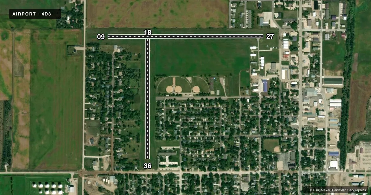
Full pagePattern entry · RWY 36
LEFT TRAFFIC| Runway | Heading (°M) | Length | Surface | Traffic |
|---|---|---|---|---|
| 09/27 | 85° / 265° | 2,873 ft | ASPH | 27 R |
| 18/36Favored | 175° / 355° | 2,200 ft | TURF | 18 R |
Runway end performance
| End | TORA | TODA | ASDA | LDA | VGSI | Approach lights | Obstruction |
|---|---|---|---|---|---|---|---|
| 09 | — | — | — | — | — | — | 41', trees, 200' from thr, 143' R of cntrln, slope 0 |
| 27 | — | — | — | — | — | — | 59', tree, 550' from thr, 173' R of cntrln, slope 9 |
| 18 | — | — | — | — | — | — | 26', tree, 208' from thr, 145' R of cntrln, slope 8 |
| 36 | — | — | — | — | — | — | 50', tree, 633' from thr, 87' R of cntrln, slope 12 |
Declared distances in feet. TORA = takeoff run available, TODA = takeoff distance, ASDA = accelerate-stop, LDA = landing distance.
Airport sketch
Runways drawn to scale from FAA survey coordinates, rendered over satellite imagery. Not for navigation.
Approaches & charts
Services on the field
Fuel grades, oxygen, maintenance, ramp storage and lighting — as declared to the FAA by the airport operator.
Fuel & services
- Fuel
- 100LL
- Oxygen (bottled)
- Not available
- Oxygen (bulk)
- Not available
- Airframe repair
- Not available
- Power plant repair
- Not available
Ramp & ground
- Transient storage
- Tie-down
- Landing fee
- No fee published
- Lighting schedule
- SS-SR
- Wind indicator
- Lighted
- Segmented circle
- Yes
Fuel & FBOs
Cheapest 100LL and Jet A on the field and nearby. Always confirm with the FBO before taxi.
Airport notes
Surface conditions, obstructions, local procedures, lighting outages and other notes published with each FAA cycle.
General notes
- RY 27 IS CALM WIND RY.
- FOR CD CTC MINNEAPOLIS ARTCC AT 651-463-5588.
- NO SNOW REMOVAL RWY 18/36. RWY CLSD WHEN SNOW CONDS EXIST.
Fuel notes
- 100LLSELF SERVE 100LL.
Approach & departure obstructions
- 0941 FT TREES 190 FT FM RWY END 143 FT R ON APCH 0:1 CLEARANCE.
- 09RWY 9 APCH SLP 5:1 TO DTHR.
- 1818/36 MARKED WITH YELLOW CONES.
- 09CONTROLLING OBSTN EXCEEDS A 45 DEG SLP.
- 27RY 27 APCH SLOPE 24:1 TO DSPLCD THLD.
- 36RY 36 APCH SLOPE 20:1 TO DSPLCD THLD.
- 09RWY 27 APCH SLP 15:1 TO DTHR.
Other notes
- THIS AIRPORT HAS BEEN SURVEYED BY THE NATIONAL GEODETIC SURVEY.
- PRVDD RWY APCHS IS MAINT FOR MIN 20:1 GLIDE SLOPE & TRSNL SFC MAINT FOR 7:1 SLOPE.
VFR map & nearby airports
VFR sectional. Tap any ICAO chip to open that airport.
Key facts · 4D8
Answer card- ICAO
- 4D8
- Name
- FULLER
- Location
- MILFORD, IOWA
- Elevation
- 1,439 ft MSL
- Traffic pattern altitude
- 2,439 ft MSL (1,000 AGL)
- Control tower
- Non-towered (use CTAF)
- Total runways
- 2
- Longest runway
- 09/27 · 2,873 ft
- Published ILS approaches
- 0
- Published frequencies
- 1
- Magnetic variation
- 5°
- Current flight rules
- VFR
- Current wind
- 010° at 14 kt
- Favored runway now
- RWY 36
Fuller Airport sits in Milford, Iowa. The field elevation is 1,439 ft MSL. It has two runways. The longest is Runway 09/27 at 2,873 ft of asphalt. Runway 18/36 is 2,200 ft of turf. There is no control tower. CTAF is 122.9. No ILS approaches are published here.
Pattern altitude is not published. Use the standard 1,000 ft AGL for light piston traffic unless the current Chart Supplement says otherwise. PS Aviation is on the field. It carries self-serve 100LL. The airport remarks also note that Runway 27 is the calm wind runway. Runway 18/36 has no snow removal. It is closed when snow is on the field.
This is a small non-towered airport with published runway slope and obstruction notes that matter on final. Runway 09 has a steep approach environment with trees near the end of the runway. Runway 27 also has a published approach slope to the displaced threshold. Runway 36 has a published approach slope as well. If you are planning a first visit, brief the runway lengths, the turf surface on 18/36 and the lack of ILS before you go. For clearance delivery, the Chart Supplement says to contact Minneapolis ARTCC.