METAR & TAF KSPW
Current METAR
Observed 10:53Z
KSPW 271053Z AUTO 00000KT 1 1/4SM BR CLR 23/23 A2977 RMK AO2 SLP069 T02280228
- Wind
- 000° @ 0 kt
- Visibility
- 0.25 SM
- Temp / Dew
- 23°C / 23°C
- Altimeter
- 29.77 inHg
- Clouds
- CLR
- Density alt
- 2,806 ft
- Ceiling
- Unlimited
- Rules
- LIFR
Airport info & contacts
Manager on record, flight service, ARTCC, attendance schedule and pattern altitude — published by the FAA and refreshed every 28 days.
Location
- From city
- 3 NM NW
- VFR sectional
- OMAHA
- ARTCC
- ZMP · MINNEAPOLIS
- NOTAM facility
- SPW (NOTAM-D)
Airport manager
- Name
- MARK WHITE
- Phone
- 712-262-1000
- Address
- 101 WEST 5TH STREET, SPENCER IA 51301
Flight service · Hours
- FSS FOD
- FORT DODGE1-800-WX-BRIEF
- Attendance
- MON-FRI · 0700-1900
- SAT-SUN · 0800-1700
Frequencies
Tap any row to copy the frequency to your clipboard.
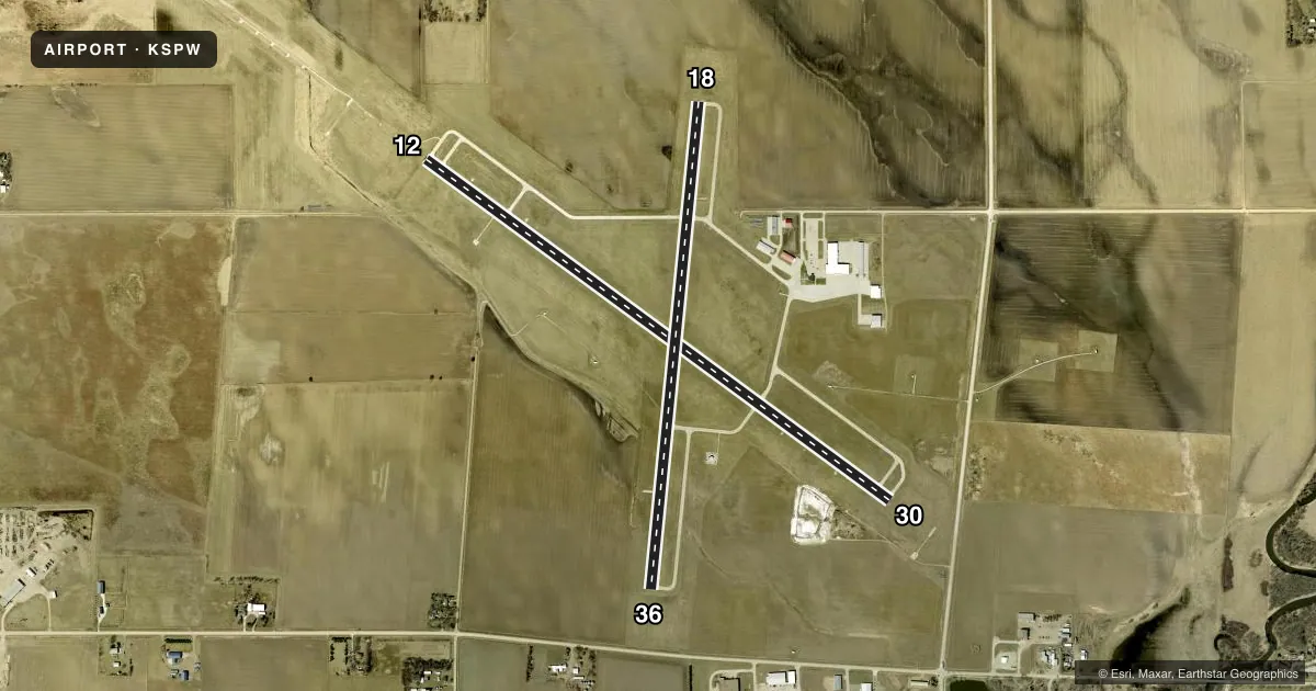
Runways & pattern
Full pagePattern entry · RWY 12
LEFT TRAFFIC| Runway | Heading (°M) | Length | Surface | Traffic |
|---|---|---|---|---|
| 12/30 | 121° / 301° | 6,001 ft | CONC | Standard L |
| 18/36 | 181° / 1° | 5,100 ft | CONC | Standard L |
Runway end performance
| End | TORA | TODA | ASDA | LDA | VGSI | Approach lights | Obstruction |
|---|---|---|---|---|---|---|---|
| 12 | — | — | — | — | VASI 4-box left(3°) | MALSR | — |
| 30 | — | — | — | — | VASI 2-box left(3°) | — | 15', road, 750' from thr, 0' R of cntrln, slope 36 |
| 18 | — | — | — | — | PAPI 4-box left(3°) | — | — |
| 36 | — | — | — | — | PAPI 4-box left(3°) | — | 18', road, 560' from thr, 0' R of cntrln, slope 20 |
Declared distances in feet. TORA = takeoff run available, TODA = takeoff distance, ASDA = accelerate-stop, LDA = landing distance.
Airport sketch
Runways drawn to scale from FAA survey coordinates, rendered over satellite imagery. Not for navigation.
Approaches & charts
ILS · 1
Services on the field
Fuel grades, oxygen, maintenance, ramp storage and lighting — as declared to the FAA by the airport operator.
Fuel & services
- Fuel
- 100LLA
- Airframe repair
- Major
- Power plant repair
- Major
- Other services
- AVNCS,CHTR,INSTR,RNTL,SALES
Ramp & ground
- Transient storage
- Tie-down
- Hangar
- Landing fee
- No fee published
- Customs
- Not available
- Lighting schedule
- SEE RMK
- Beacon schedule
- SS-SR
- Beacon
- White / Green (civil land)(WG)
- Wind indicator
- Lighted
- Segmented circle
- No
Fuel & FBOs
Cheapest 100LL and Jet A on the field and nearby. Always confirm with the FBO before taxi.
Airport notes
Surface conditions, obstructions, local procedures, lighting outages and other notes published with each FAA cycle.
General notes
- WATERFOWL INVOF ARPT.
- RY 12 IS CALM WIND RY.
- FOR CD IF UNA TO CTC ON FSS FREQ, CTC MINNEAPOLIS ARTCC AT 651-463-5588.
Lighting notes
- ACTVT MIRL RYS 12/30 & 18/36; MALSR RY 12; VASI RYS 12 & 30; PAPI RYS 18 & 36; REIL RYS 30; 18 & 36 - CTAF.
Approach & departure obstructions
- 30APCH SLOPE 50:1 FROM DSPLCD THR.
Other notes
- EXISTED PRIOR TO 1959.
- 1FOR ATTENDANT AFTER HOURS CALL (712) 262-1000.
VFR map & nearby airports
VFR sectional. Tap any ICAO chip to open that airport.
Key facts · KSPW
Answer card- ICAO
- KSPW
- Name
- SPENCER MUNI
- Location
- SPENCER, IOWA
- Elevation
- 1,338.9 ft MSL
- Traffic pattern altitude
- 2,338.9 ft MSL (1,000 AGL)
- Control tower
- Non-towered (use CTAF)
- Total runways
- 2
- Longest runway
- 12/30 · 6,001 ft
- Published ILS approaches
- 1
- Published frequencies
- 2
- Magnetic variation
- 5°
- Current flight rules
- LIFR
- Current wind
- 000° at 0 kt
- Favored runway now
- –
Spencer Muni is in Spencer, Iowa. The field elevation is 1,338.9 ft MSL. It has two concrete runways. The longest is runway 12/30 at 6,001 ft. There is no control tower, so expect CTAF and UNICOM work on 123.0. Runway 12 has the ILS. The published pattern altitude is not listed, so use the standard 1,000 ft AGL unless the current FAA Chart Supplement says otherwise.
Leading Edge Aviation is on the field. It carries 100LL and Jet A. The phone number in the facts is (712) 262-1000. Published remarks also note medium intensity runway lights on both runways. Runway 12 has approach lighting with runway alignment indicators. Runway 30 has runway end identifier lights. The field also notes waterfowl in the area. That matters on arrival and departure. Especially near the runway ends.
For a first-time pilot, the main things to brief are the elevation, the non-towered flow and the runway lighting setup. Runway 12 is listed as the calm wind runway. The airport has one ILS approach. Check the current procedure and weather before you go. If you need after-hours help, the published remark says to call the FBO number. For clearance delivery when Flight Service is not available, the published remark points pilots to Minneapolis ARTCC at 651-463-5588.