METAR & TAF KSHL
Current METAR
Observed 19:55Z
KSHL 131955Z AUTO 34019G26KT 10SM CLR 24/09 A2989 RMK AO2
- Wind
- 340° @ 19G26 kt
- Visibility
- 10 SM
- Temp / Dew
- 24°C / 9°C
- Altimeter
- 29.89 inHg
- Clouds
- CLR
- Density alt
- 2,877 ft
- Ceiling
- Unlimited
- Rules
- VFR
Airport info & contacts
Manager on record, flight service, ARTCC, attendance schedule and pattern altitude — published by the FAA and refreshed every 28 days.
Location
- From city
- 2 NM NE
- VFR sectional
- OMAHA
- ARTCC
- ZMP · MINNEAPOLIS
- NOTAM facility
- SHL (NOTAM-D)
Airport manager
- Name
- LYLE VUST
- Phone
- 712-324-4005
- Address
- 3020 NORTHWEST BOULEVARD, SHELDON IA 51201-7508
Flight service · Hours
- FSS FOD
- FORT DODGE1-800-WX-BRIEF
- Attendance
- MON - FRI · 0730 - 1700
- SAT - SUN · ON CALL
Frequencies
Tap any row to copy the frequency to your clipboard.
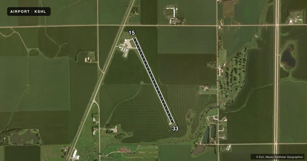
Runways & pattern
Full pagePattern entry · RWY 33
LEFT TRAFFICRunway end performance
| End | TORA | TODA | ASDA | LDA | VGSI | Approach lights | Obstruction |
|---|---|---|---|---|---|---|---|
| 15 | — | — | — | — | PAPI 2-box left(3°) | — | 15', road, 500' from thr, 165' R of cntrln, slope 20 |
| 33 | — | — | — | — | PAPI 2-box left(3°) | — | 38', trees, 1490' from thr, 400' R of cntrln, slope 33 |
Declared distances in feet. TORA = takeoff run available, TODA = takeoff distance, ASDA = accelerate-stop, LDA = landing distance.
Airport sketch
Runways drawn to scale from FAA survey coordinates, rendered over satellite imagery. Not for navigation.
Approaches & charts
Services on the field
Fuel grades, oxygen, maintenance, ramp storage and lighting — as declared to the FAA by the airport operator.
Fuel & services
- Fuel
- 100LLA
- Oxygen (bottled)
- Not available
- Oxygen (bulk)
- Not available
- Airframe repair
- Major
- Power plant repair
- Major
- Other services
- CHTR,INSTR,RNTL,SALES
Ramp & ground
- Transient storage
- Tie-down
- Hangar
- Landing fee
- No fee published
- Customs
- Not available
- Lighting schedule
- SEE RMK
- Beacon schedule
- SS-SR
- Beacon
- White / Green (civil land)(WG)
- Wind indicator
- Lighted
- Segmented circle
- No
Fuel & FBOs
Cheapest 100LL and Jet A on the field and nearby. Always confirm with the FBO before taxi.
Airport notes
Surface conditions, obstructions, local procedures, lighting outages and other notes published with each FAA cycle.
General notes
- RY 33 IS CALM WIND RY.
- FOR CD CTC MINNEAPOLIS ARTCC AT 651-463-5588.
Lighting notes
- ACTVT MIRL RY 15/33; PAPI AND REIL RYS 15 & 33 - CTAF.
Other notes
- 1FOR SERVICE AFTER HRS CALL 712-324-4005 OR 324-1900.
VFR map & nearby airports
VFR sectional. Tap any ICAO chip to open that airport.
Key facts · KSHL
Answer card- ICAO
- KSHL
- Name
- SHELDON RGNL
- Location
- SHELDON, IOWA
- Elevation
- 1,419.2 ft MSL
- Traffic pattern altitude
- 2,419.2 ft MSL (1,000 AGL)
- Control tower
- Non-towered (use CTAF)
- Total runways
- 1
- Longest runway
- 15/33 · 4,199 ft
- Published ILS approaches
- 0
- Published frequencies
- 2
- Magnetic variation
- 5°
- Current flight rules
- VFR
- Current wind
- 340° at 19 kt
- Favored runway now
- RWY 33
Sheldon Rgnl Airport sits in Sheldon, Iowa. The field elevation is 1,419.2 ft MSL. It has one runway. Runway 15/33 is 4,199 ft long with a concrete surface. There is no control tower. CTAF and UNICOM are both 122.8. No ILS approaches are published here.
The published pattern altitude is not listed. For a light piston, plan on the standard 1,000 ft AGL unless the current Chart Supplement says otherwise. Runway 33 is the calm wind runway. Medium intensity runway lights are available on 15/33. PAPI and runway end identifier lights are available on runways 15 and 33. They are controlled by CTAF.
Midwest Flying Service is on the field. It carries 100LL and Jet A. For after-hours service, call the number in the Chart Supplement or the FBO directly. If you need a clearance, Minneapolis ARTCC is listed for clearance delivery. At this elevation, pay attention to density altitude on warm days. The runway is long enough for normal GA use. You still want to plan your takeoff and landing performance with the local weather in mind.