METAR & TAF KSXK
Current METAR
Observed 20:15Z
KSXK 272015Z AUTO 04005KT 10SM CLR 33/19 A2983 RMK AO2
- Wind
- 040° @ 5 kt
- Visibility
- 10 SM
- Temp / Dew
- 33°C / 19°C
- Altimeter
- 29.83 inHg
- Clouds
- CLR
- Density alt
- 4,019 ft
- Ceiling
- Unlimited
- Rules
- VFR
Airport info & contacts
Manager on record, flight service, ARTCC, attendance schedule and pattern altitude — published by the FAA and refreshed every 28 days.
Location
- From city
- 1 NM N
- VFR sectional
- OMAHA
- ARTCC
- ZMP · MINNEAPOLIS
- NOTAM facility
- FOD (NOTAM-D)
Airport manager
- Name
- ANDREW SCHREIER
- Phone
- 712-567-1000
- Address
- 3153 460TH STREET, MAURICE IA 51036
Flight service · Hours
- FSS FOD
- FORT DODGE1-800-WX-BRIEF
- Attendance
- MON-FRI · 0600-1800
- SAT · 0800-1200
Frequencies
Tap any row to copy the frequency to your clipboard.
Runways & pattern
Full pagePattern entry · RWY 35
LEFT TRAFFICRunway end performance
| End | TORA | TODA | ASDA | LDA | VGSI | Approach lights | Obstruction |
|---|---|---|---|---|---|---|---|
| 17 | — | — | — | — | PAPI 4-box left(3°) | — | — |
| 35 | — | — | — | — | PAPI 4-box left(3°) | MALSR | — |
Declared distances in feet. TORA = takeoff run available, TODA = takeoff distance, ASDA = accelerate-stop, LDA = landing distance.
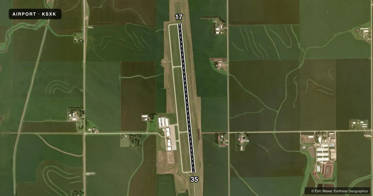
Airport sketch
Runways drawn to scale from FAA survey coordinates, rendered over satellite imagery. Not for navigation.
Approaches & charts
Services on the field
Fuel grades, oxygen, maintenance, ramp storage and lighting — as declared to the FAA by the airport operator.
Fuel & services
- Fuel
- 100LLA+
- Oxygen (bottled)
- HIGH/LOW
- Airframe repair
- Major
- Power plant repair
- Major
- Other services
- AFRT,AGRI,CHTR,INSTR,RNTL
Ramp & ground
- Transient storage
- Tie-down
- Hangar
- Landing fee
- No fee published
- Lighting schedule
- SEE RMK
- Beacon schedule
- SS-SR
- Beacon
- White / Green (civil land)(WG)
- Wind indicator
- Lighted
Fuel & FBOs
Cheapest 100LL and Jet A on the field and nearby. Always confirm with the FBO before taxi.
Airport notes
Surface conditions, obstructions, local procedures, lighting outages and other notes published with each FAA cycle.
General notes
- FOR CD CTC SIOUX CITY ATCT ON 124.6 OR CALL 712-293-2482.
Lighting notes
- ACTVT MALSR RWY 35; REIL RWY17; PAPI RWY 17 & 35; MIRL RWY 17/35 - CTAF.
Fuel notes
- 100LLSELF SVC FUEL H24.
Other notes
- 1SFC COND UNMNT 1800-0600 MON-FRI & WKEND.
VFR map & nearby airports
VFR sectional. Tap any ICAO chip to open that airport.
Key facts · KSXK
Answer card- ICAO
- KSXK
- Name
- SIOUX COUNTY RGNL
- Location
- MAURICE, IOWA
- Elevation
- 1,408.9 ft MSL
- Traffic pattern altitude
- 2,408.9 ft MSL (1,000 AGL)
- Control tower
- Non-towered (use CTAF)
- Total runways
- 1
- Longest runway
- 17/35 · 5,500 ft
- Published ILS approaches
- 0
- Published frequencies
- 4
- Magnetic variation
- 2°
- Current flight rules
- VFR
- Current wind
- 040° at 5 kt
- Favored runway now
- RWY 35
Sioux County Rgnl sits near Maurice, Iowa. The field elevation is 1,408.9 ft MSL. It has one runway. Runway 17/35 is 5,500 ft long with a concrete surface. There is no control tower. Clearance delivery goes through Sioux City ATC on 124.6 or by phone if needed. No ILS approaches are published here, so plan with the current chart and weather in mind.
Pattern altitude is not published. Use 1,000 ft AGL for light piston operations unless the current Chart Supplement says otherwise. That puts the pattern at about 2,408.9 ft MSL based on the listed field elevation. AirFlair is on the field. It carries 100LL, Jet A and Jet A Prist. Self-serve 100LL is available 24 hours a day. Runway 35 has MALSR lighting. Runway 17 has runway end identifier lights. Both runways have PAPI. The medium intensity runway lights are controlled by CTAF.
This is a non-towered field, so standard CTAF discipline matters. Surface conditions are unmonitored from 1800 to 0600 Monday through Friday. They are also unmonitored on weekends. If you are planning a night arrival or a winter departure, check the current Chart Supplement and call the airport operator or AirFlair before you go. The runway length is workable for a lot of light aircraft. Still, the elevation is high enough that density altitude can matter on warm days.