METAR & TAF 7K7
7K7 does not publish a METAR.
Showing the nearest reporting station: KSUX (SIOUX GATEWAY/BRIG GENERAL BUD DAY FLD) · 9.5 NM away. Conditions at 7K7 may differ.
METAR · KSUX
Observed 21:52Z
KSUX 232152Z 14007KT 10SM FEW044 26/16 A3008 RMK AO2 SLP182 T02560161
- Wind
- 140° @ 7 kt
- Visibility
- 10 SM
- Temp / Dew
- 26°C / 16°C
- Altimeter
- 30.08 inHg
- Clouds
- FEW
- Density alt
- 2,497 ft
- Ceiling
- Unlimited
- Rules
- VFR
Airport info & contacts
Manager on record, flight service, ARTCC, attendance schedule and pattern altitude — published by the FAA and refreshed every 28 days.
Location
- From city
- 1 NM N
- VFR sectional
- OMAHA
- ARTCC
- ZMP · MINNEAPOLIS
- NOTAM facility
- HON (NOTAM-D)
Airport manager
- Name
- MC COOK INDUSTRIES
- Phone
- (605) 232-4830
- Address
- PO BOX 158, NORTH SIOUX CITY SD 57049
Flight service · Hours
- FSS HON
- HURON1-800-WX-BRIEF
- Attendance
- ATNDD · MON - SAT · 0800 - 1700
Frequencies
Tap any row to copy the frequency to your clipboard.
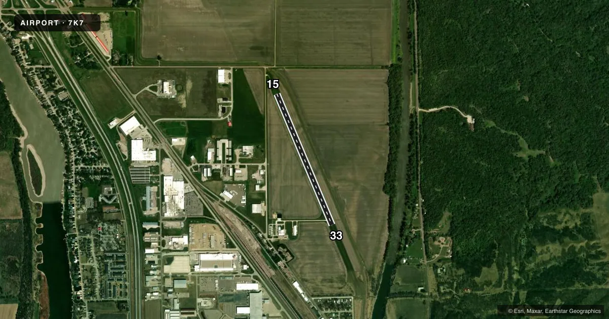
Runways & pattern
Full pagePattern entry · RWY 15
RIGHT TRAFFICAirport sketch
Runways drawn to scale from FAA survey coordinates, rendered over satellite imagery. Not for navigation.
Approaches & charts
Services on the field
Fuel grades, oxygen, maintenance, ramp storage and lighting — as declared to the FAA by the airport operator.
Fuel & services
- Fuel
- 100LLA
- Oxygen (bottled)
- Not available
- Oxygen (bulk)
- Not available
- Airframe repair
- Not available
- Power plant repair
- Not available
- Other services
- INSTR
Ramp & ground
- Transient storage
- Tie-down
- Landing fee
- No fee published
- Customs
- Not available
- Wind indicator
- Yes
- Segmented circle
- No
Fuel & FBOs
Cheapest 100LL and Jet A on the field and nearby. Always confirm with the FBO before taxi.
Airport notes
Surface conditions, obstructions, local procedures, lighting outages and other notes published with each FAA cycle.
General notes
- FOR CD CTC SIOUX CITY ATCT AT 712-293-2482. WHEN SUX ATCT CLSD, FOR CD CTC MINNEAPOLIS ARTCC AT 651-463-5588.
Fuel notes
- 100LLFUEL AVBL H24 VIA CREDIT CARD.
- AFUEL AVBL H24 VIA CREDIT CARD.
VFR map & nearby airports
VFR sectional. Tap any ICAO chip to open that airport.
Key facts · 7K7
Answer card- ICAO
- 7K7
- Name
- GRAHAM FLD
- Location
- NORTH SIOUX CITY, SOUTH DAKOTA
- Elevation
- 1,109 ft MSL
- Traffic pattern altitude
- 2,109 ft MSL (1,000 AGL)
- Control tower
- Non-towered (use CTAF)
- Total runways
- 1
- Longest runway
- 15/33 · 3,233 ft
- Published ILS approaches
- 0
- Published frequencies
- 1
- Magnetic variation
- 7°
- Current flight rules
- VFR
- Current wind
- 140° at 7 kt
- Favored runway now
- RWY 15
Graham Fld sits in North Sioux City, South Dakota. The field elevation is 1,109 ft MSL. It has one runway, 15/33, which is 3,233 ft long and has a concrete surface. There is no control tower. CTAF is 122.9.
No ILS approaches are published here. Pattern altitude is not published, so use the standard 1,000 ft AGL for light piston traffic unless the current Chart Supplement says otherwise. The airport has 24-hour self-serve fuel with credit card access. Both 100LL and fuel A are available. There are no on-field FBOs listed in the facts. Call the airport operator or the field directly if you need current service details before arrival.
For a first-time stop, the main things to plan for are the single runway layout, the lack of tower service and the field elevation. Runway 15/33 is the only landing surface, so pay attention to wind and performance on a 3,233 ft strip. If you need IFR clearance, the published remarks say to contact Sioux City Air Traffic Control Tower at 712-293-2482. When Sioux City Tower is closed, use Minneapolis ARTCC at 651-463-5588 for clearance delivery.