METAR & TAF KMEY
KMEY does not publish a METAR.
Showing the nearest reporting station: KDNS (DENISON MUNI) · 21.7 NM away. Conditions at KMEY may differ.
METAR · KDNS
Observed 15:55Z
KDNS 271555Z AUTO VRB04KT CLR 33/25 A2980 RMK AO2
- Wind
- VAR @ 4 kt
- Visibility
- —
- Temp / Dew
- 33°C / 25°C
- Altimeter
- 29.80 inHg
- Clouds
- CLR
- Density alt
- 3,693 ft
- Ceiling
- Unlimited
- Rules
- VFR
Airport info & contacts
Manager on record, flight service, ARTCC, attendance schedule and pattern altitude — published by the FAA and refreshed every 28 days.
Location
- From city
- 1 NM N
- VFR sectional
- OMAHA
- ARTCC
- ZMP · MINNEAPOLIS
- NOTAM facility
- FOD (NOTAM-D)
Airport manager
- Name
- KARLA UHL
- Phone
- 712-881-1890
- Address
- 513 MAIN STREET, MAPLETON IA 51034
Flight service · Hours
- FSS FOD
- FORT DODGE1-800-WX-BRIEF
- Attendance
- MON-FRI · 0800-1700
Frequencies
Tap any row to copy the frequency to your clipboard.
Runways & pattern
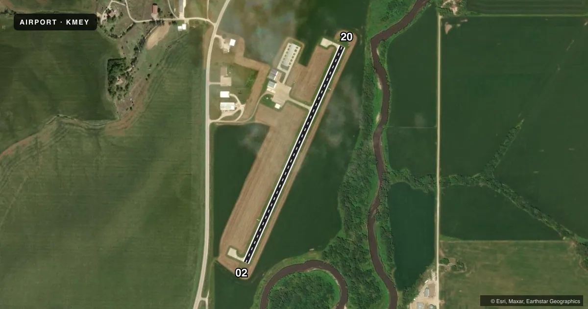
Full pagePattern entry · RWY 02
LEFT TRAFFICRunway end performance
| End | TORA | TODA | ASDA | LDA | VGSI | Approach lights | Obstruction |
|---|---|---|---|---|---|---|---|
| 02 | — | — | — | — | PAPI 2-box left(3.75°) | — | 36', tree, 1014' from thr, 77' R of cntrln, slope 22 |
| 20 | — | — | — | — | PAPI 2-box left(3.75°) | — | — |
Declared distances in feet. TORA = takeoff run available, TODA = takeoff distance, ASDA = accelerate-stop, LDA = landing distance.
Airport sketch
Runways drawn to scale from FAA survey coordinates, rendered over satellite imagery. Not for navigation.
Approaches & charts
Services on the field
Fuel grades, oxygen, maintenance, ramp storage and lighting — as declared to the FAA by the airport operator.
Fuel & services
- Fuel
- 100
- Oxygen (bottled)
- Not available
- Oxygen (bulk)
- Not available
- Airframe repair
- Major
- Power plant repair
- Major
Ramp & ground
- Transient storage
- Tie-down
- Hangar
- Landing fee
- No fee published
- Customs
- Not available
- Lighting schedule
- SEE RMK
- Beacon schedule
- SS-SR
- Beacon
- White / Green (civil land)(WG)
- Wind indicator
- Lighted
- Segmented circle
- No
Fuel & FBOs
Cheapest 100LL and Jet A on the field and nearby. Always confirm with the FBO before taxi.
Airport notes
Surface conditions, obstructions, local procedures, lighting outages and other notes published with each FAA cycle.
General notes
- RY 20 IS CALM WIND RY.
- FOR CD CTC SIOUX CITY ATCT ON 124.6 OR CALL 712-293-2482.
- RWY 20 PAPI UNUSBL BYD 7 DEGS LEFT OF CNTRLN.
Lighting notes
- ACTVT REIL RWY 20; PAPI RWY 02 & 20; MIRL RWY 02/20 - CTAF.
Other notes
- THIS AIRPORT HAS BEEN SURVEYED BY THE NATIONAL GEODETIC SURVEY.
VFR map & nearby airports
VFR sectional. Tap any ICAO chip to open that airport.
Key facts · KMEY
Answer card- ICAO
- KMEY
- Name
- JAMES G WHITING MEML FLD
- Location
- MAPLETON, IOWA
- Elevation
- 1,116 ft MSL
- Traffic pattern altitude
- 2,116 ft MSL (1,000 AGL)
- Control tower
- Non-towered (use CTAF)
- Total runways
- 1
- Longest runway
- 02/20 · 2,801 ft
- Published ILS approaches
- 0
- Published frequencies
- 4
- Magnetic variation
- 5°
- Current flight rules
- VFR
- Current wind
- 000° at 4 kt
- Favored runway now
- RWY 02
James G Whiting Meml Fld sits in Mapleton, Iowa. The field elevation is 1,116 ft MSL. It has one runway. Runway 02/20 is 2,801 ft long with a concrete surface. The airport is not towered. Use CTAF 122.8. For clearance delivery, contact Sioux City ATC on 124.6 or call 712-293-2482.
No ILS approaches are published here. Pattern altitude is not published in the facts, so verify the current Chart Supplement before flying the pattern. The published notes also say Runway 20 is the calm wind runway. Runway 20 has runway end identifier lights. Medium intensity runway lights are installed on both runway ends. PAPI is installed on Runways 02 and 20. The Runway 20 PAPI is unusable beyond 7 degrees left of centerline.
Whiting Memorial Field is on the field. It carries AVGAS 100LL. Call (712) 881-2764 for current availability before arrival. This is a small non-towered field with a single short runway, so plan your arrival with the wind and lighting in mind. If you need current noise, curfew, or pattern details beyond the published remarks, check the current Chart Supplement before you go.