METAR & TAF KCKP
Current METAR
Observed 15:55Z
KCKP 271555Z AUTO 03008KT 10SM CLR 33/27 A2980 RMK AO2
- Wind
- 030° @ 8 kt
- Visibility
- 10 SM
- Temp / Dew
- 33°C / 27°C
- Altimeter
- 29.80 inHg
- Clouds
- CLR
- Density alt
- 3,830 ft
- Ceiling
- Unlimited
- Rules
- VFR
Airport info & contacts
Manager on record, flight service, ARTCC, attendance schedule and pattern altitude — published by the FAA and refreshed every 28 days.
Location
- From city
- 1 NM S
- VFR sectional
- OMAHA
- ARTCC
- ZMP · MINNEAPOLIS
- NOTAM facility
- CKP (NOTAM-D)
Airport manager
- Name
- SAVANNAH NELSON
- Phone
- 712-225-2810
- Address
- 1201 S 2ND ST, CHEROKEE IA 51012
Flight service · Hours
- FSS FOD
- FORT DODGE1-800-WX-BRIEF
- Attendance
- MON-FRI · 0900-1700
Frequencies
Tap any row to copy the frequency to your clipboard.
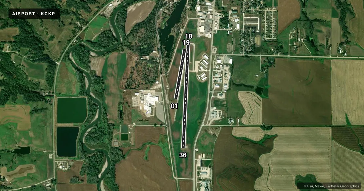
Runways & pattern
Full pagePattern entry · RWY 01
LEFT TRAFFIC| Runway | Heading (°M) | Length | Surface | Traffic |
|---|---|---|---|---|
| 18/36 | 178° / 358° | 4,001 ft | CONC | Standard L |
| 01/19Favored | 6° / 186° | 1,941 ft | TURF | Standard L |
Runway end performance
| End | TORA | TODA | ASDA | LDA | VGSI | Approach lights | Obstruction |
|---|---|---|---|---|---|---|---|
| 18 | — | — | — | — | PAPI 4-box left(3°) | — | 40', trees, 749' from thr, 193' R of cntrln, slope 13 |
| 36 | — | — | — | — | PAPI 4-box left(3°) | — | 69', tree, 2189' from thr, 287' R of cntrln, slope 28 |
| 01 | — | — | — | — | — | — | 29', rr, 211' from thr, 125' R of cntrln, slope 7 |
| 19 | — | — | — | — | — | — | 51', trees, 1755' from thr, 61' R of cntrln, slope 34 |
Declared distances in feet. TORA = takeoff run available, TODA = takeoff distance, ASDA = accelerate-stop, LDA = landing distance.
Airport sketch
Runways drawn to scale from FAA survey coordinates, rendered over satellite imagery. Not for navigation.
Approaches & charts
Services on the field
Fuel grades, oxygen, maintenance, ramp storage and lighting — as declared to the FAA by the airport operator.
Fuel & services
- Fuel
- 100LLA
- Airframe repair
- Major
- Power plant repair
- Major
- Other services
- INSTR,RNTL
Ramp & ground
- Transient storage
- Tie-down
- Hangar
- Landing fee
- No fee published
- Customs
- Not available
- Lighting schedule
- SEE RMK
- Beacon schedule
- SS-SR
- Beacon
- White / Green (civil land)(WG)
- Wind indicator
- Lighted
- Segmented circle
- No
Fuel & FBOs
Cheapest 100LL and Jet A on the field and nearby. Always confirm with the FBO before taxi.
Airport notes
Surface conditions, obstructions, local procedures, lighting outages and other notes published with each FAA cycle.
General notes
- WATERFOWL ON & INVOF ARPT.
- FOR CD CTC MINNEAPOLIS ARTCC AT 651-463-5588.
- RWY 1/19 CLSD WHEN SNOW CONDITIONS EXIST.
Lighting notes
- ACTVT MIRL RWY 18/36; REIL & PAPI RWYS 18 & 36 - CTAF.
Fuel notes
- 100LL24 HOUR SELF SERVE FUEL AVAILABLE
Runway surface & condition
- 01/19CLSD NOV-APR.
Approach & departure obstructions
- 01RY 01/19 THLDS & SIDES MARKED WITH YELLOW CONES.
- 01APCH SLOPE 27:1 APCH SLOPE TO DSPLCD THLD.
Other notes
- 1FOR ATTENDANT AFT HRS CALL 712-225-2810.
VFR map & nearby airports
VFR sectional. Tap any ICAO chip to open that airport.
Key facts · KCKP
Answer card- ICAO
- KCKP
- Name
- CHEROKEE COUNTY RGNL
- Location
- CHEROKEE, IOWA
- Elevation
- 1,227 ft MSL
- Traffic pattern altitude
- 2,227 ft MSL (1,000 AGL)
- Control tower
- Non-towered (use CTAF)
- Total runways
- 2
- Longest runway
- 18/36 · 4,001 ft
- Published ILS approaches
- 0
- Published frequencies
- 2
- Magnetic variation
- 5°
- Current flight rules
- VFR
- Current wind
- 030° at 8 kt
- Favored runway now
- RWY 01
Cherokee County Rgnl sits in Cherokee, Iowa. The field elevation is 1,227 ft MSL. It has two runways. The longest is 18/36 at 4,001 ft of concrete. Runway 01/19 is turf at 1,941 ft. There is no control tower. CTAF and UNICOM are both 122.8. No ILS approaches are published here.
Pattern altitude is not published. Use the standard 1,000 ft AGL for light piston operations unless the current Chart Supplement says otherwise. Top Notch is on the field. It carries 100LL and Jet A. Twenty-four hour self-serve fuel is available. If you need an attendant after hours, the published number is 712-225-2810.
A few operational notes matter here. Waterfowl are reported on and near the airport. Runway 01/19 is closed when snow conditions exist. It is also closed November through April. The 01/19 thresholds and sides are marked with yellow cones. Runway 18/36 has medium intensity lights. REILs and PAPIs are on 18 and 36. They are controlled by CTAF. The approach slope to the displaced threshold on 01 is 27 to 1. For clearance delivery, contact Minneapolis ARTCC at 651-463-5588. Check the current Chart Supplement before departure for any updates.