METAR & TAF KSLB
Current METAR
Observed 18:15Z
KSLB 271815Z AUTO 01008KT 330V030 10SM CLR 32/21 A2982 RMK AO2
- Wind
- 010° @ 8 kt
- Visibility
- 10 SM
- Temp / Dew
- 32°C / 21°C
- Altimeter
- 29.82 inHg
- Clouds
- CLR
- Density alt
- 4,009 ft
- Ceiling
- Unlimited
- Rules
- VFR
Airport info & contacts
Manager on record, flight service, ARTCC, attendance schedule and pattern altitude — published by the FAA and refreshed every 28 days.
Location
- From city
- 3 NM SW
- VFR sectional
- OMAHA
- ARTCC
- ZMP · MINNEAPOLIS
- NOTAM facility
- SLB (NOTAM-D)
Airport manager
- Name
- JIM BARTHOLOMEW
- Phone
- 712-732-6494
- Address
- 850 630TH ST, STORM LAKE IA 50588
Flight service · Hours
- FSS FOD
- FORT DODGE1-800-WX-BRIEF
- Attendance
- JUNE - SEPT · MON-SAT · 0800-1700
- OCT - MAY · MON - SAT · 0900 - 1700
Frequencies
Tap any row to copy the frequency to your clipboard.
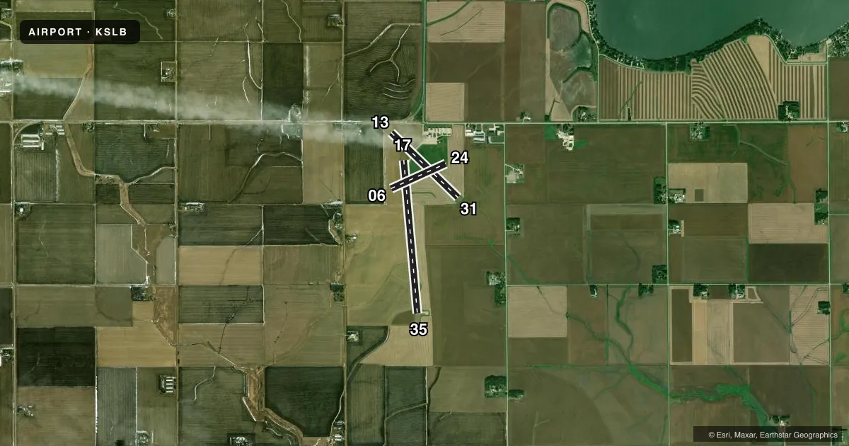
Runways & pattern
Full pagePattern entry · RWY 35
LEFT TRAFFIC| Runway | Heading (°M) | Length | Surface | Traffic |
|---|---|---|---|---|
| 17/35Favored | 171° / 351° | 5,002 ft | CONC | Standard L |
| 13/31 | 130° / 310° | 3,034 ft | CONC | Standard L |
| 06/24 | 62° / 242° | 1,962 ft | TURF | Standard L |
Runway end performance
| End | TORA | TODA | ASDA | LDA | VGSI | Approach lights | Obstruction |
|---|---|---|---|---|---|---|---|
| 17 | — | — | — | — | PAPI 2-box left(3°) | — | — |
| 35 | — | — | — | — | PAPI 2-box left(3°) | — | — |
| 13 | — | — | — | — | — | — | 24', road, 460' from thr, 0' R of cntrln, slope 10 |
Declared distances in feet. TORA = takeoff run available, TODA = takeoff distance, ASDA = accelerate-stop, LDA = landing distance.
Airport sketch
Runways drawn to scale from FAA survey coordinates, rendered over satellite imagery. Not for navigation.
Approaches & charts
Services on the field
Fuel grades, oxygen, maintenance, ramp storage and lighting — as declared to the FAA by the airport operator.
Fuel & services
- Fuel
- 100A
- Oxygen (bottled)
- Not available
- Oxygen (bulk)
- Not available
- Airframe repair
- Major
- Power plant repair
- Major
- Other services
- AGRI,INSTR,RNTL,SALES
Ramp & ground
- Transient storage
- Tie-down
- Hangar
- Landing fee
- No fee published
- Customs
- Not available
- Lighting schedule
- SEE RMK
- Beacon schedule
- SS-SR
- Beacon
- White / Green (civil land)(WG)
- Wind indicator
- Lighted
- Segmented circle
- No
Fuel & FBOs
Cheapest 100LL and Jet A on the field and nearby. Always confirm with the FBO before taxi.
Airport notes
Surface conditions, obstructions, local procedures, lighting outages and other notes published with each FAA cycle.
General notes
- RY 35 IS CALM WIND RY.
- FOR CD CTC MINNEAPOLIS ARTCC AT 651-463-5588.
Lighting notes
- ACTVT MIRL RWY 13/31 & RWY 17/35 & REIL RWY 17 & 35- CTAF. PAPI RWYS 17 & 35 OPER CONTINUOUSLY.
Approach & departure obstructions
- 0606/24 MARKED WITH YELLOW CONES.
- 13APCH RATIO FM DSPLCD THR 26:1.
Other notes
- PROVIDED APCH TO EACH RY CLEAR FOR A 20:1 GLIDE SLOPE & MNTN A CLEAR TRSNL SFC FOR A 7:1 SLOPE.
- 1FOR ATTANDANT AFTER HRS CALL 712-732-6301.
- MANAGEREVENING PHONE 712-732-6301
- 06/24CLSD WINTER MONTHS NOV THRU MAR.
VFR map & nearby airports
VFR sectional. Tap any ICAO chip to open that airport.
Key facts · KSLB
Answer card- ICAO
- KSLB
- Name
- STORM LAKE MUNI
- Location
- STORM LAKE, IOWA
- Elevation
- 1,487.9 ft MSL
- Traffic pattern altitude
- 2,487.9 ft MSL (1,000 AGL)
- Control tower
- Non-towered (use CTAF)
- Total runways
- 3
- Longest runway
- 17/35 · 5,002 ft
- Published ILS approaches
- 0
- Published frequencies
- 2
- Magnetic variation
- 4°
- Current flight rules
- VFR
- Current wind
- 010° at 8 kt
- Favored runway now
- RWY 35
Storm Lake Muni sits in Storm Lake, Iowa. The field elevation is 1,487.9 ft MSL. It has three runways. The longest is 17/35 at 5,002 ft. This is an untowered airport, so plan to self-announce on CTAF 122.7. Pattern altitude is not published. Use the standard 1,000 ft AGL pattern for light piston traffic unless the current Chart Supplement or local procedures say otherwise.
No ILS approaches are published here. Bart's Flying Service is on the field. It carries 100LL and Jet A. Call ahead at (712) 732-6494 if you need current service details. The airport remarks also note that runway 35 is the calm wind runway. Runway 17 and runway 35 have medium intensity lights. REILs are on those two runways. PAPI is listed as operating continuously on 17 and 35. Runway 06/24 is a turf strip. It is marked with yellow cones and is closed in the winter months from November through March.
The airport sits at a higher field elevation for the region. That means performance planning matters on warm days. Check density altitude before departure. Runway 13 has a displaced threshold note in the remarks. Clearance delivery for IFR work goes through Minneapolis ARTCC at 651-463-5588. For any current operational detail, verify with the airport operator or the FBO directly by phone.