METAR & TAF KSKI
KSKI does not publish a METAR.
Showing the nearest reporting station: KSLB (STORM LAKE MUNI) · 17.5 NM away. Conditions at KSKI may differ.
METAR · KSLB
Observed 18:15Z
KSLB 271815Z AUTO 01008KT 330V030 10SM CLR 32/21 A2982 RMK AO2
- Wind
- 010° @ 8 kt
- Visibility
- 10 SM
- Temp / Dew
- 32°C / 21°C
- Altimeter
- 29.82 inHg
- Clouds
- CLR
- Density alt
- 3,713 ft
- Ceiling
- Unlimited
- Rules
- VFR
Airport info & contacts
Manager on record, flight service, ARTCC, attendance schedule and pattern altitude — published by the FAA and refreshed every 28 days.
Location
- From city
- 3 NM S
- VFR sectional
- OMAHA
- ARTCC
- ZMP · MINNEAPOLIS
- NOTAM facility
- FOD (NOTAM-D)
Airport manager
- Name
- KEN MYERS
- Phone
- 712-662-7801
- Address
- 3062 280 TH ST, SAC CITY IA 50583
Flight service · Hours
- FSS FOD
- FORT DODGE1-800-WX-BRIEF
- Attendance
- MON-FRI · 0800-1600
Frequencies
Tap any row to copy the frequency to your clipboard.
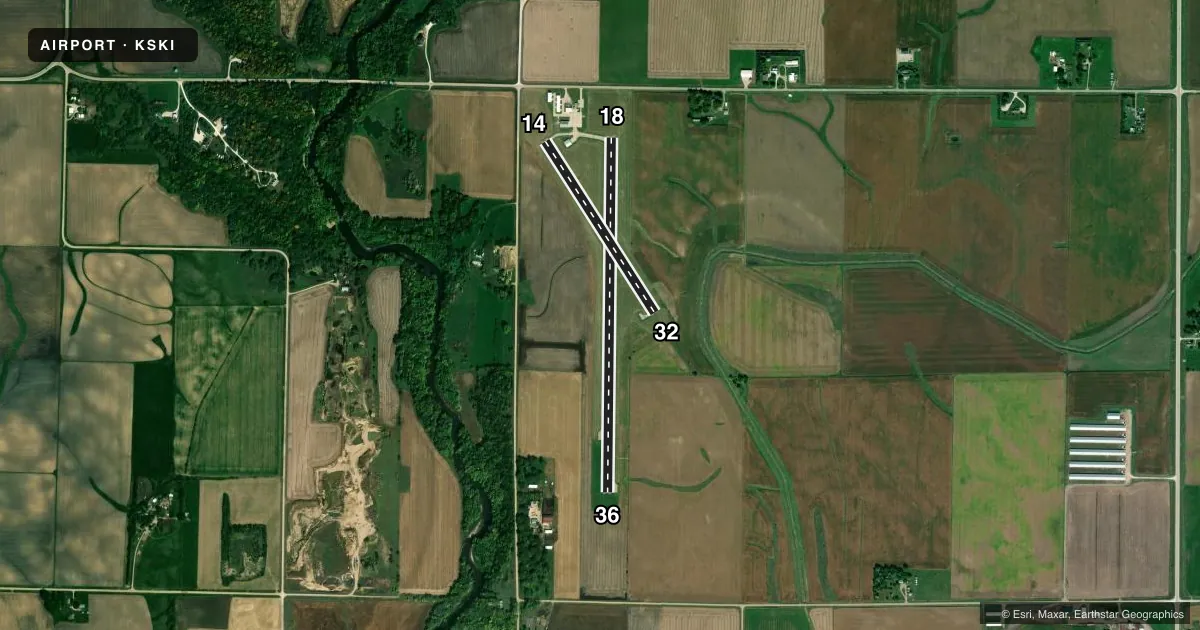
Runways & pattern
Full pagePattern entry · RWY 36
LEFT TRAFFIC| Runway | Heading (°M) | Length | Surface | Traffic |
|---|---|---|---|---|
| 18/36Favored | 177° / 357° | 4,100 ft | CONC | Standard L |
| 14/32 | 143° / 323° | 2,350 ft | CONC | Standard L |
Runway end performance
| End | TORA | TODA | ASDA | LDA | VGSI | Approach lights | Obstruction |
|---|---|---|---|---|---|---|---|
| 18 | — | — | — | — | PAPI 2-box left(3°) | — | 15', road, 560' from thr, 0' R of cntrln, slope 24 |
| 36 | — | — | — | — | PAPI 2-box left(3°) | — | 91', pline, 3760' from thr, 0' R of cntrln, slope 39 |
| 14 | — | — | — | — | PAPI 2-box left(3.5°) | — | — |
| 32 | — | — | — | — | PAPI 2-box left(3.5°) | — | — |
Declared distances in feet. TORA = takeoff run available, TODA = takeoff distance, ASDA = accelerate-stop, LDA = landing distance.
Airport sketch
Runways drawn to scale from FAA survey coordinates, rendered over satellite imagery. Not for navigation.
Approaches & charts
Services on the field
Fuel grades, oxygen, maintenance, ramp storage and lighting — as declared to the FAA by the airport operator.
Fuel & services
- Fuel
- 100LL
- Oxygen (bottled)
- Not available
- Oxygen (bulk)
- Not available
- Airframe repair
- Minor
- Power plant repair
- Minor
- Other services
- INSTR,RNTL,SALES
Ramp & ground
- Transient storage
- Tie-down
- Hangar
- Landing fee
- No fee published
- Customs
- Not available
- Lighting schedule
- SEE RMK
- Beacon schedule
- SS-SR
- Beacon
- White / Green (civil land)(WG)
- Wind indicator
- Lighted
- Segmented circle
- No
Fuel & FBOs
Cheapest 100LL and Jet A on the field and nearby. Always confirm with the FBO before taxi.
Airport notes
Surface conditions, obstructions, local procedures, lighting outages and other notes published with each FAA cycle.
General notes
- LINE OF SIGHT PROBLEMS EXIST BTN RYS 36 & 14/32.
- MATT WALLACE - CHAIRMAN ARPT CMSN (712) 662-4806.
- RY 36 IS CALM WIND RY.
- FOR CD CTC MINNEAPOLIS ARTCC AT 651-463-5588.
Lighting notes
- ACTVT MIRL RWYS 14/32 & 18/36; PAPI RWYS 14, 18, 32 & 36; REIL RWY 36 - CTAF.
Other notes
- EXISTED PRIOR TO 1959.
- MANAGERAFTER HOURS: 712-830-9562
VFR map & nearby airports
VFR sectional. Tap any ICAO chip to open that airport.
Key facts · KSKI
Answer card- ICAO
- KSKI
- Name
- SAC CITY MUNI
- Location
- SAC CITY, IOWA
- Elevation
- 1,249.5 ft MSL
- Traffic pattern altitude
- 2,249.5 ft MSL (1,000 AGL)
- Control tower
- Non-towered (use CTAF)
- Total runways
- 2
- Longest runway
- 18/36 · 4,100 ft
- Published ILS approaches
- 0
- Published frequencies
- 2
- Magnetic variation
- 4°
- Current flight rules
- VFR
- Current wind
- 010° at 8 kt
- Favored runway now
- RWY 36
Sac City Muni sits in Sac City, Iowa. The field elevation is 1,249.5 ft MSL. It has two concrete runways. The longest is 4,100 ft on runway 18/36. There is no control tower. CTAF and UNICOM are both 122.8.
No ILS approaches are published here. The pattern altitude is not published, so a light piston pilot should plan on the standard 1,000 ft AGL unless the current Chart Supplement says otherwise. Runway 36 is the calm wind runway. Medium intensity runway lights are available on both runways. PAPI is installed on 14, 18, 32 and 36. REIL is installed on runway 36 and is controlled by CTAF.
There are no on-field FBOs listed in the facts, so call the airport operator or the field directly before arrival if you need current fuel or service details. Clearance delivery is handled through Minneapolis ARTCC. One operational note matters here. There are line of sight problems between runway 36 and runway 14/32. Keep that in mind when you are moving on the ground or coordinating traffic. The airport also sits at a moderate elevation for the region, so performance planning should still be part of your brief.