METAR & TAF KCIN
Current METAR
Observed 14:55Z
KCIN 271455Z AUTO VRB06KT 9SM CLR 31/25 A2979 RMK AO2
- Wind
- VAR @ 6 kt
- Visibility
- 9 SM
- Temp / Dew
- 31°C / 25°C
- Altimeter
- 29.79 inHg
- Clouds
- CLR
- Density alt
- 3,574 ft
- Ceiling
- Unlimited
- Rules
- VFR
Airport info & contacts
Manager on record, flight service, ARTCC, attendance schedule and pattern altitude — published by the FAA and refreshed every 28 days.
Location
- From city
- 4 NM SE
- VFR sectional
- OMAHA
- ARTCC
- ZMP · MINNEAPOLIS
- NOTAM facility
- CIN (NOTAM-D)
Airport manager
- Name
- DONALD MENSEN
- Phone
- 712-792-4980
- Address
- 21177 QUAIL AVE, CARROLL IA 51401
Flight service · Hours
- FSS FOD
- FORT DODGE1-800-WX-BRIEF
- Attendance
- 0800-DUSK
Frequencies
Tap any row to copy the frequency to your clipboard.
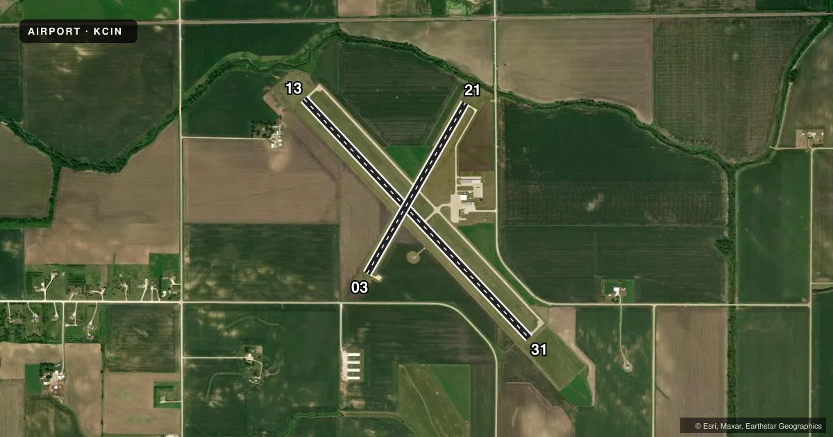
Runways & pattern
Full pagePattern entry · RWY 03
LEFT TRAFFIC| Runway | Heading (°M) | Length | Surface | Traffic |
|---|---|---|---|---|
| 13/31 | 135° / 315° | 5,506 ft | CONC | Standard L |
| 03/21Favored | 28° / 208° | 3,301 ft | CONC | Standard L |
Runway end performance
| End | TORA | TODA | ASDA | LDA | VGSI | Approach lights | Obstruction |
|---|---|---|---|---|---|---|---|
| 13 | — | — | — | — | PAPI 4-box left(3°) | — | 33', rr, 1329' from thr, 529' R of cntrln, slope 34 |
| 31 | — | — | — | — | PAPI 4-box left(3°) | — | — |
| 03 | — | — | — | — | PAPI 2-box left(3°) | — | 14', road, 480' from thr, 140' R of cntrln, slope 20 |
| 21 | — | — | — | — | PAPI 2-box left(3°) | — | 24', road, 700' from thr, 140' R of cntrln, slope 20 |
Declared distances in feet. TORA = takeoff run available, TODA = takeoff distance, ASDA = accelerate-stop, LDA = landing distance.
Airport sketch
Runways drawn to scale from FAA survey coordinates, rendered over satellite imagery. Not for navigation.
Approaches & charts
Services on the field
Fuel grades, oxygen, maintenance, ramp storage and lighting — as declared to the FAA by the airport operator.
Fuel & services
- Fuel
- 100LLA
- Oxygen (bottled)
- Not available
- Oxygen (bulk)
- Not available
- Airframe repair
- Major
- Power plant repair
- Major
- Other services
- CHTR,INSTR,RNTL,SALES
Ramp & ground
- Transient storage
- Tie-down
- Hangar
- Landing fee
- No fee published
- Customs
- Not available
- Lighting schedule
- SEE RMK
- Beacon schedule
- SS-SR
- Beacon
- White / Green (civil land)(WG)
- Wind indicator
- Lighted
- Segmented circle
- No
Fuel & FBOs
Cheapest 100LL and Jet A on the field and nearby. Always confirm with the FBO before taxi.
Airport notes
Surface conditions, obstructions, local procedures, lighting outages and other notes published with each FAA cycle.
General notes
- RY 31 IS CALM WIND RY.
- FOR CD CTC MINNEAPOLIS ARTCC AT 651-463-5588.
Lighting notes
- DUSK-DAWN. MIRL RYS 13/31 & 03/21 PRESET ON LOW INTST; TO INCR INTST & ACTVT PAPI RYS 13/31 & 03/21 AND REIL RYS 13/31 & 03/21 - CTAF.
Approach & departure obstructions
- 13APCH SLOPE 50:1 FROM DSPLCD THLD.
Other notes
- 1FOR SVC AFTER HOURS CALL 712-792-4980.
- OWNERNORMAN HUTCHESON CHMN ARPT CMSN, PHONE 792-2621.
VFR map & nearby airports
VFR sectional. Tap any ICAO chip to open that airport.
Key facts · KCIN
Answer card- ICAO
- KCIN
- Name
- ARTHUR N NEU
- Location
- CARROLL, IOWA
- Elevation
- 1,203.7 ft MSL
- Traffic pattern altitude
- 2,203.7 ft MSL (1,000 AGL)
- Control tower
- Non-towered (use CTAF)
- Total runways
- 2
- Longest runway
- 13/31 · 5,506 ft
- Published ILS approaches
- 0
- Published frequencies
- 2
- Magnetic variation
- 2°
- Current flight rules
- VFR
- Current wind
- 000° at 6 kt
- Favored runway now
- RWY 03
Arthur N Neu Airport sits in Carroll, Iowa. Field elevation is 1,203.7 ft MSL. It has two concrete runways. The longest is 13/31 at 5,506 ft. There is no control tower. CTAF and UNICOM are both 122.8.
No ILS approaches are published here. Pattern altitude is not published, so use the standard 1,000 ft AGL for light piston operations unless the current Chart Supplement says otherwise. Runway 31 is listed as the calm wind runway. That is useful in a light crosswind situation.
Carroll Aviation is on the field. It carries 100LL and Jet A Prist. Call (712) 792-4980 for current service or after-hours help. The airport remarks also note that runway 13 has a 50:1 approach slope from the displaced threshold. From dusk to dawn, the runway lights are preset on low intensity. Use CTAF to increase lighting intensity. Use CTAF as well if you need the PAPI or runway end identifier lights on the published runways.
This is an uncontrolled field with two paved runways. Plan your arrival with the current Chart Supplement in hand. Check the runway lighting setup before night work. If you need clearance delivery, Minneapolis ARTCC is listed for that purpose.