METAR & TAF KGCT
KGCT does not publish a METAR.
Showing the nearest reporting station: KPRO (PERRY MUNI) · 14.9 NM away. Conditions at KGCT may differ.
METAR · KPRO
Observed 20:15Z
KPRO 272015Z AUTO 30003KT 10SM CLR 35/29 A2975 RMK AO2 T03520293 $
- Wind
- 300° @ 3 kt
- Visibility
- 10 SM
- Temp / Dew
- 35°C / 29°C
- Altimeter
- 29.75 inHg
- Clouds
- CLR
- Density alt
- 4,124 ft
- Ceiling
- Unlimited
- Rules
- VFR
Airport info & contacts
Manager on record, flight service, ARTCC, attendance schedule and pattern altitude — published by the FAA and refreshed every 28 days.
Location
- From city
- 3 NM E
- VFR sectional
- OMAHA
- ARTCC
- ZMP · MINNEAPOLIS
- NOTAM facility
- FOD (NOTAM-D)
Airport manager
- Name
- LANCE LEVIS
- Phone
- 712-304-0140
- Address
- 4279 PANORAMA DRIVE, P.O. BOX 34, PANORA IA 50216
Flight service · Hours
- FSS FOD
- FORT DODGE1-800-WX-BRIEF
- Attendance
- Unattended
Frequencies
Tap any row to copy the frequency to your clipboard.
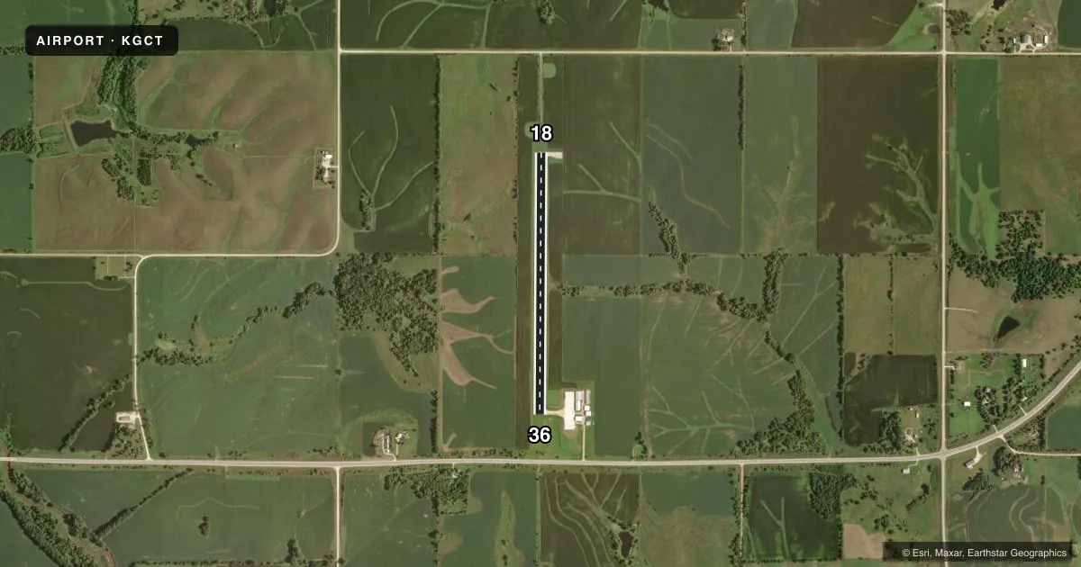
Runways & pattern
Full pagePattern entry · RWY 36
LEFT TRAFFICRunway end performance
| End | TORA | TODA | ASDA | LDA | VGSI | Approach lights | Obstruction |
|---|---|---|---|---|---|---|---|
| 18 | — | — | — | — | PAPI 2-box left(3.25°) | — | 10', brush, 425' from thr, 5' R of cntrln, slope 22 |
| 36 | — | — | — | — | PAPI 2-box left(3.25°) | — | 20', pole, 727' from thr, 256' R of cntrln, slope 26 |
Declared distances in feet. TORA = takeoff run available, TODA = takeoff distance, ASDA = accelerate-stop, LDA = landing distance.
Airport sketch
Runways drawn to scale from FAA survey coordinates, rendered over satellite imagery. Not for navigation.
Approaches & charts
Services on the field
Fuel grades, oxygen, maintenance, ramp storage and lighting — as declared to the FAA by the airport operator.
Fuel & services
- Fuel
- 100LL
- Oxygen (bottled)
- Not available
- Oxygen (bulk)
- Not available
- Airframe repair
- Not available
- Power plant repair
- Not available
Ramp & ground
- Transient storage
- Tie-down
- Lighting schedule
- SEE RMK
- Beacon schedule
- SS-SR
- Beacon
- White / Green (civil land)(WG)
- Wind indicator
- Lighted
- Segmented circle
- No
Fuel & FBOs
Cheapest 100LL and Jet A on the field and nearby. Always confirm with the FBO before taxi.
Airport notes
Surface conditions, obstructions, local procedures, lighting outages and other notes published with each FAA cycle.
General notes
- FOR CD CTC DES MOINES ATCT AT 515-974- 8016.
Lighting notes
- MIRL RY 18/36 PRESET LOW INTST; TO INCR INTST & ACTVT PAPI RYS 18 & 36; REIL RYS 18 & 36 - CTAF.
Approach & departure obstructions
- 36PAPI UNUSBL BYD 8 DEGS RIGHT OF CNTRLN.
Other notes
- PRVDD APCH MAINTAINED TO 20:1 GLIDESLOPE; TRANSITIONAL SFC MAINTAINED FOR A 7:1 SLOPE; EXISTING ARPT BE ABANDONED.
- MANAGERALT NUMBER 641-757-2046
VFR map & nearby airports
VFR sectional. Tap any ICAO chip to open that airport.
Key facts · KGCT
Answer card- ICAO
- KGCT
- Name
- GUTHRIE COUNTY RGNL
- Location
- GUTHRIE CENTER, IOWA
- Elevation
- 1,220.5 ft MSL
- Traffic pattern altitude
- 2,220.5 ft MSL (1,000 AGL)
- Control tower
- Non-towered (use CTAF)
- Total runways
- 1
- Longest runway
- 18/36 · 3,400 ft
- Published ILS approaches
- 0
- Published frequencies
- 4
- Magnetic variation
- 3°
- Current flight rules
- VFR
- Current wind
- 300° at 3 kt
- Favored runway now
- RWY 36
Guthrie County Rgnl sits in Guthrie Center, Iowa. Field elevation is 1,220.5 ft MSL. The airport has one runway, 18/36, at 3,400 ft of concrete. There is no control tower. Pattern altitude is not published. Use the standard 1,000 ft AGL pattern unless current local guidance says otherwise.
No ILS approaches are published here. The field sits in the Des Moines area flow for approach and departure services. CTAF is 122.8. UNICOM is 122.8. Published remarks say the runway lights on 18/36 are preset to low intensity. Use CTAF to increase light intensity. That also activates PAPI on 18 and 36 plus REIL on both ends. The PAPI on runway 36 is unusable beyond 8 degrees right of centerline. Clearance delivery is handled through Des Moines Air Traffic Control Tower.
There are no on-field FBOs listed in the facts. Check with the airport operator or the FBO directly by phone before arrival for current services. The published remarks also note an alternate manager phone number. Pilots should also note the remark that the airport is planned to be abandoned. Verify current status in the FAA Chart Supplement before you go. At 1,220.5 ft MSL, expect a little more density altitude effect than a lowland strip on a warm day.