METAR & TAF KEFW
KEFW does not publish a METAR.
Showing the nearest reporting station: KPRO (PERRY MUNI) · 13.7 NM away. Conditions at KEFW may differ.
METAR · KPRO
Observed 13:15Z
KPRO 271315Z AUTO 22003KT 10SM CLR 28/27 A2975 RMK AO2 T02840272 $
- Wind
- 220° @ 3 kt
- Visibility
- 10 SM
- Temp / Dew
- 28°C / 27°C
- Altimeter
- 29.75 inHg
- Clouds
- CLR
- Density alt
- 3,069 ft
- Ceiling
- Unlimited
- Rules
- VFR
Airport info & contacts
Manager on record, flight service, ARTCC, attendance schedule and pattern altitude — published by the FAA and refreshed every 28 days.
Location
- From city
- 2 NM E
- VFR sectional
- OMAHA
- ARTCC
- ZMP · MINNEAPOLIS
- NOTAM facility
- FOD (NOTAM-D)
Airport manager
- Name
- SCOTT PETERSON
- Phone
- 515-386-3111
- Address
- 220 NORTH CHESTNUT STREET, JEFFERSON IA 50129
Flight service · Hours
- FSS FOD
- FORT DODGE1-800-WX-BRIEF
- Attendance
- Unattended
Frequencies
Tap any row to copy the frequency to your clipboard.
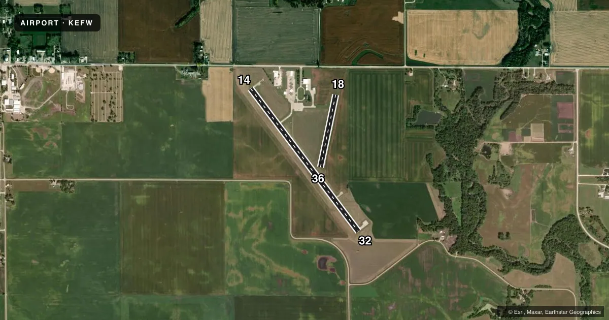
Runways & pattern
Full pagePattern entry · RWY 18
LEFT TRAFFIC| Runway | Heading (°M) | Length | Surface | Traffic |
|---|---|---|---|---|
| 14/32 | 140° / 320° | 4,100 ft | CONC | Standard L |
| 18/36Favored | 189° / 9° | 1,696 ft | TURF | Standard L |
Runway end performance
| End | TORA | TODA | ASDA | LDA | VGSI | Approach lights | Obstruction |
|---|---|---|---|---|---|---|---|
| 14 | — | — | — | — | PAPI 2-box left(3°) | — | 20', road, 640' from thr, 0' R of cntrln, slope 22 |
| 32 | — | — | — | — | PAPI 2-box left(3°) | — | — |
| 18 | — | — | — | — | — | — | 19', road, 590' from thr, 0' R of cntrln, slope 31 |
| 36 | — | — | — | — | — | — | 42', pline, 1700' from thr, 0' R of cntrln, slope 40 |
Declared distances in feet. TORA = takeoff run available, TODA = takeoff distance, ASDA = accelerate-stop, LDA = landing distance.
Airport sketch
Runways drawn to scale from FAA survey coordinates, rendered over satellite imagery. Not for navigation.
Approaches & charts
Services on the field
Fuel grades, oxygen, maintenance, ramp storage and lighting — as declared to the FAA by the airport operator.
Fuel & services
- Fuel
- 100LL
- Oxygen (bottled)
- Not available
- Oxygen (bulk)
- Not available
- Airframe repair
- Minor
- Power plant repair
- Minor
- Other services
- AGRI
Ramp & ground
- Transient storage
- Tie-down
- Hangar
- Landing fee
- No fee published
- Customs
- Not available
- Lighting schedule
- SEE RMK
- Beacon schedule
- SS-SR
- Beacon
- White / Green (civil land)(WG)
- Wind indicator
- Lighted
- Segmented circle
- No
Fuel & FBOs
Cheapest 100LL and Jet A on the field and nearby. Always confirm with the FBO before taxi.
Airport notes
Surface conditions, obstructions, local procedures, lighting outages and other notes published with each FAA cycle.
General notes
- RY 32 IS CALM WIND RY.
- FOR CD CTC MINNEAPOLIS ARTCC AT 651-463-5588.
Lighting notes
- DUSK-DAWN. ACTVT REIL RWY 14 & 32; MIRL RWY 14/32 - CTAF. PAPI RWY 14 & 32 OPR CONSLY
Approach & departure obstructions
- 1818/36 MKD WITH YELLOW CONES.
- 36RUNWAY 18/36 MARKED WITH YELLOW CONES
Other notes
- MANAGEROR 515-386-2136 (POLICE)
VFR map & nearby airports
VFR sectional. Tap any ICAO chip to open that airport.
Key facts · KEFW
Answer card- ICAO
- KEFW
- Name
- JEFFERSON MUNI
- Location
- JEFFERSON, IOWA
- Elevation
- 1,047.3 ft MSL
- Traffic pattern altitude
- 2,047.3 ft MSL (1,000 AGL)
- Control tower
- Non-towered (use CTAF)
- Total runways
- 2
- Longest runway
- 14/32 · 4,100 ft
- Published ILS approaches
- 0
- Published frequencies
- 2
- Magnetic variation
- 3°
- Current flight rules
- VFR
- Current wind
- 220° at 3 kt
- Favored runway now
- RWY 18
Jefferson Muni sits in Jefferson, Iowa. The field elevation is 1,047.3 ft MSL. It has two runways. The longest is 4,100 ft on runway 14/32, which is concrete. Runway 18/36 is 1,696 ft and turf. There is no control tower. CTAF and UNICOM are both 122.8. No ILS approaches are published here.
The pattern altitude is not published. For light piston ops, plan on the standard 1,000 ft AGL unless the current Chart Supplement says otherwise. Runway 14/32 has medium intensity lights that are CTAF controlled. REILs are installed on 14 and 32. PAPI is on 14 and 32. Lighting runs from dusk to dawn. Runway 32 is listed as the calm wind runway. Runways 18 and 36 are marked with yellow cones, so expect a lighter turf option with visual marking only.
Jefferson Municipal Airport is on field and carries 100LL. If you need current fuel or ramp details, call the field at (515) 386-4429. For clearance delivery, Minneapolis ARTCC is listed in the remarks. This is a non-towered airport with a modest elevation. Watch your density altitude on warm days. Use the current Chart Supplement for any local operating notes before you go.