METAR & TAF KAMW
Current METAR
Observed 12:53Z
KAMW 271253Z AUTO 15004KT 10SM CLR 28/24 A2977 RMK AO2 SLP067 T02830244
- Wind
- 150° @ 4 kt
- Visibility
- 10 SM
- Temp / Dew
- 28°C / 24°C
- Altimeter
- 29.77 inHg
- Clouds
- CLR
- Density alt
- 2,931 ft
- Ceiling
- Unlimited
- Rules
- VFR
Airport info & contacts
Manager on record, flight service, ARTCC, attendance schedule and pattern altitude — published by the FAA and refreshed every 28 days.
Location
- From city
- 2 NM SE
- VFR sectional
- OMAHA
- ARTCC
- ZMP · MINNEAPOLIS
- NOTAM facility
- AMW (NOTAM-D)
Airport manager
- Name
- DAMION PREGITZER
- Phone
- 515-239-5275
- Address
- 515 CLARK AVE, AMES IA 50010
Flight service · Hours
- FSS FOD
- FORT DODGE1-800-WX-BRIEF
- Attendance
- DAWN-DUSK
Frequencies
Tap any row to copy the frequency to your clipboard.
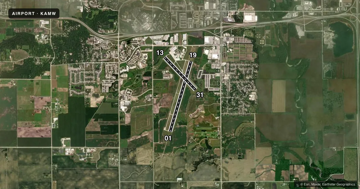
Runways & pattern
Full pagePattern entry · RWY 13
RIGHT TRAFFIC| Runway | Heading (°M) | Length | Surface | Traffic |
|---|---|---|---|---|
| 01/19 | 14° / 194° | 5,701 ft | ASPH | 01 R |
| 13/31Favored | 133° / 313° | 3,491 ft | CONC | 13 R |
Runway end performance
| End | TORA | TODA | ASDA | LDA | VGSI | Approach lights | Obstruction |
|---|---|---|---|---|---|---|---|
| 01 | — | — | — | — | — | MALSR | 46', tree, 2167' from thr, 191' R of cntrln, slope 42 |
| 19 | — | — | — | — | VASI 4-box left(4°) | — | 87', tree, 2400' from thr, 345' R of cntrln, slope 25 |
| 13 | — | — | — | — | — | — | 7', tree, 340' from thr, 95' R of cntrln, slope 20 |
| 31 | — | — | — | — | — | — | 83', tree, 2812' from thr, 0' R of cntrln, slope 31 |
Declared distances in feet. TORA = takeoff run available, TODA = takeoff distance, ASDA = accelerate-stop, LDA = landing distance.
Airport sketch
Runways drawn to scale from FAA survey coordinates, rendered over satellite imagery. Not for navigation.
Approaches & charts
ILS · 1
Services on the field
Fuel grades, oxygen, maintenance, ramp storage and lighting — as declared to the FAA by the airport operator.
Fuel & services
- Fuel
- 100A
- Oxygen (bottled)
- Not available
- Airframe repair
- Major
- Power plant repair
- Major
- Other services
- CHTR,INSTR,RNTL,SALES
Ramp & ground
- Transient storage
- Tie-down
- Hangar
- Landing fee
- No fee published
- Customs
- Not available
- Lighting schedule
- SEE RMK
- Beacon schedule
- SS-SR
- Beacon
- White / Green (civil land)(WG)
- Wind indicator
- Lighted
- Segmented circle
- Yes
Fuel & FBOs
Cheapest 100LL and Jet A on the field and nearby. Always confirm with the FBO before taxi.
Airport notes
Surface conditions, obstructions, local procedures, lighting outages and other notes published with each FAA cycle.
General notes
- BE ALERT FOR GLIDER & ULTRALIGHT OPNS INVOF ARPT.
- BIRD AND DEER ACT ON & INVOF ARPT
- RWY 01 IS CALM WIND RWY.
- STADIUM WI 3 NM, CHECK FOR EVENTS.
- COLD TEMPERATURE AIRPORT. ALTITUDE CORRECTION REQUIRED AT OR BELOW -26C.
- FOR CD CTC DES MOINES ATCT ON 126.0 OR CALL 515-974- 8016.
Lighting notes
- ACTVT MALSR RWY 01; VASI RWYS 19; HIRL RWY 01/19 & MIRL RWY 13/31 - CTAF.
Approach & departure obstructions
- 1332 FT TREE 124 FT FM RWY END AND 158 FT R ON APCH; CLNC SLOPE 1:1
VFR map & nearby airports
VFR sectional. Tap any ICAO chip to open that airport.
Key facts · KAMW
Answer card- ICAO
- KAMW
- Name
- AMES MUNI
- Location
- AMES, IOWA
- Elevation
- 955.6 ft MSL
- Traffic pattern altitude
- 1,955.6 ft MSL (1,000 AGL)
- Control tower
- Non-towered (use CTAF)
- Total runways
- 2
- Longest runway
- 01/19 · 5,701 ft
- Published ILS approaches
- 1
- Published frequencies
- 5
- Magnetic variation
- 3°
- Current flight rules
- VFR
- Current wind
- 150° at 4 kt
- Favored runway now
- RWY 13
Ames Muni is in Ames, Iowa. The field elevation is 955.6 ft MSL. It has 2 runways. The longest is 01/19 at 5,701 ft. There is no control tower. Pattern altitude is not published, so use the standard 1,000 ft AGL for light piston operations unless current local guidance says otherwise.
Runway 01 has the ILS approach. Runway 01 is also the calm wind runway per the published remarks. Lighting is pilot-controlled on CTAF. Runway 01 has MALSR. Runways 13, 19 and 31 have visual approach slope indicators. Runway 01/19 has high intensity lights. Runway 13/31 has medium intensity lights.
Central Iowa Air Service is on the field. It carries 100LL and Jet A. For clearance delivery, contact Des Moines Air Traffic Control Tower on 126.0 or by phone. This field also has a tree hazard near the approach end of runway 13. The airport sits in a busy local environment with bird and deer activity. Glider and ultralight traffic is also reported nearby. A stadium is within 3 NM, so check for events before arrival. Cold weather operations matter here too. Altitude correction is required at or below minus 26 degrees Celsius.