METAR & TAF KIKV
Current METAR
Observed 17:15Z
KIKV 271715Z AUTO VRB05KT 10SM CLR 33/26 A2977 RMK AO2
- Wind
- VAR @ 5 kt
- Visibility
- 10 SM
- Temp / Dew
- 33°C / 26°C
- Altimeter
- 29.77 inHg
- Clouds
- CLR
- Density alt
- 3,474 ft
- Ceiling
- Unlimited
- Rules
- VFR
Airport info & contacts
Manager on record, flight service, ARTCC, attendance schedule and pattern altitude — published by the FAA and refreshed every 28 days.
Location
- From city
- 1 NM SE
- VFR sectional
- OMAHA
- ARTCC
- ZMP · MINNEAPOLIS
- NOTAM facility
- IKV (NOTAM-D)
Airport manager
- Name
- DAVE KALWISHKY
- Phone
- 515-965-6428
- Address
- 3700 SE CONVENIENCE BOULEVARD, ANKENY IA 50023
Flight service · Hours
- FSS FOD
- FORT DODGE1-800-WX-BRIEF
- Attendance
- 0600-2100
Frequencies
Tap any row to copy the frequency to your clipboard.
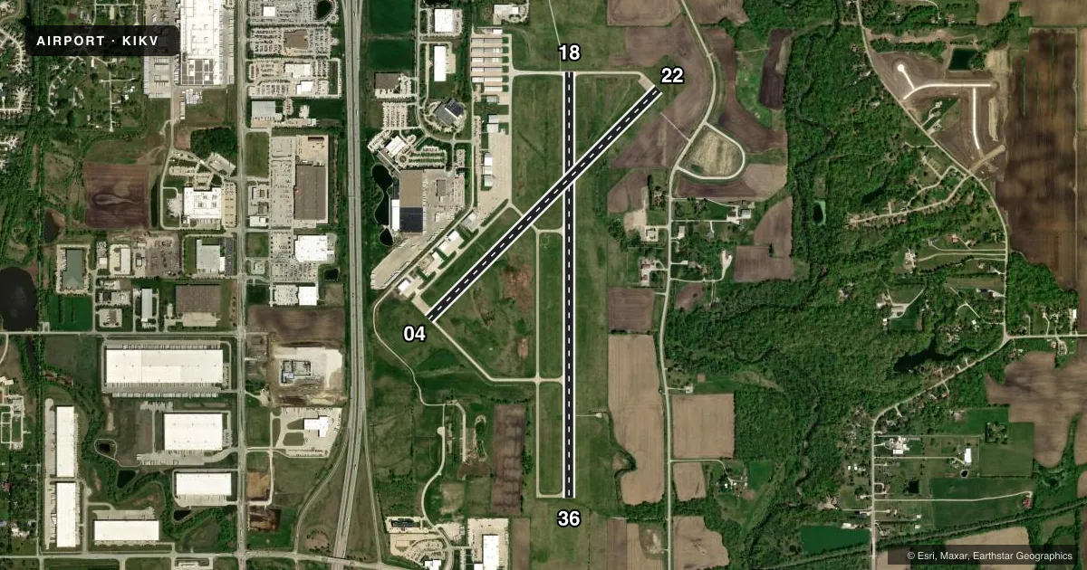
Runways & pattern
Full pagePattern entry · RWY 36
RIGHT TRAFFIC| Runway | Heading (°M) | Length | Surface | Traffic |
|---|---|---|---|---|
| 18/36Favored | 177° / 357° | 5,500 ft | CONC | 36 R |
| 04/22 | 42° / 222° | 4,200 ft | CONC | 04 R |
Runway end performance
| End | TORA | TODA | ASDA | LDA | VGSI | Approach lights | Obstruction |
|---|---|---|---|---|---|---|---|
| 18 | — | — | — | — | PAPI 2-box left(3°) | — | 49', tree, 2025' from thr, 144' R of cntrln, slope 37 |
| 36 | — | — | — | — | PAPI 2-box left(3°) | — | 20', tree, 355' from thr, 267' R of cntrln, slope 7 |
| 04 | 4,200' | 4,200' | 4,200' | 4,200' | PAPI 2-box left(4°) | — | 31', tree, 981' from thr, 100' R of cntrln, slope 25 |
| 22 | 4,200' | 4,200' | 4,200' | 4,200' | PAPI 2-box left(3°) | — | 56', trees, 1178' from thr, 146' R of cntrln, slope 17 |
Declared distances in feet. TORA = takeoff run available, TODA = takeoff distance, ASDA = accelerate-stop, LDA = landing distance.
Airport sketch
Runways drawn to scale from FAA survey coordinates, rendered over satellite imagery. Not for navigation.
Approaches & charts
ILS · 1
Services on the field
Fuel grades, oxygen, maintenance, ramp storage and lighting — as declared to the FAA by the airport operator.
Fuel & services
- Fuel
- 100LLA
- Oxygen (bottled)
- High pressure
- Oxygen (bulk)
- High pressure
- Airframe repair
- Major
- Power plant repair
- Major
- Other services
- AVNCS,CHTR,INSTR,RNTL,SALES
Ramp & ground
- Transient storage
- Tie-down
- Hangar
- Lighting schedule
- SEE RMK
- Beacon schedule
- SS-SR
- Beacon
- White / Green (civil land)(WG)
- Wind indicator
- Lighted
- Segmented circle
- Yes
Fuel & FBOs
Cheapest 100LL and Jet A on the field and nearby. Always confirm with the FBO before taxi.
Airport notes
Surface conditions, obstructions, local procedures, lighting outages and other notes published with each FAA cycle.
General notes
- EXEC 1 AVIATION - (515) 965-1020.
- AMGR REQ USE OF PREFERENTIAL RY 18 WHEN WINDS ARE LESS THAN 5 KNOTS.
- FOR CD CTC DES MOINES ATCT ON 126.65 OR CALL 515-974- 8016.
Lighting notes
- ACTVT PAPI RY 4/22; MIRL RWYS 04/22 & 18/36; REIL RWYS 4 & 18/36 - CTAF
Approach & departure obstructions
- 3647 FT TREE 177 FT FM TWY END 283 FT R OF CNTRLN, 7:1 APCH SLOPE.
Other notes
- FREQ 122.900 IS ALSO USED AS UNICOM.
VFR map & nearby airports
VFR sectional. Tap any ICAO chip to open that airport.
Key facts · KIKV
Answer card- ICAO
- KIKV
- Name
- ANKENY RGNL
- Location
- ANKENY, IOWA
- Elevation
- 909.9 ft MSL
- Traffic pattern altitude
- 1,909.9 ft MSL (1,000 AGL)
- Control tower
- Non-towered (use CTAF)
- Total runways
- 2
- Longest runway
- 18/36 · 5,500 ft
- Published ILS approaches
- 1
- Published frequencies
- 4
- Magnetic variation
- 3°
- Current flight rules
- VFR
- Current wind
- 000° at 5 kt
- Favored runway now
- RWY 36
Ankeny Rgnl sits in Ankeny, Iowa. Field elevation is 909.9 ft MSL. The airport has two concrete runways. The longest is 5,500 ft on runway 18/36. There is one ILS approach. It serves runway 36. The field is not towered. CTAF is 122.9. That same frequency is also used as UNICOM.
Pattern altitude is not published. For light piston traffic, use the standard 1,000 ft AGL unless the current Chart Supplement or ATC gives you something different. Expect Des Moines approach support on 123.9 or 307.15. Clearance delivery is handled by Des Moines Air Traffic Control Tower on 126.65 when needed.
Exec 1 Aviation is on the field. It carries 100LL and Jet A with Prist. Call (515) 965-1020 for current services. Medium intensity runway lights are on both runways. PAPI is active on runway 04/22. Runway end identifier lights are on runway 4 and runway 18/36. They operate on CTAF.
One operational item matters here. Airport manager approval is required to use preferential runway 18 when winds are less than 5 knots. Also watch the obstruction note for runway 36. There is a 47-foot tree near the taxiway end. It sits right of centerline. That makes a stabilized approach and good runway alignment important on final.