METAR & TAF I75
Current METAR
Observed 13:35Z
KI75 271335Z AUTO 20008G14KT 160V220 10SM CLR 28/24 A2979 RMK AO2 T02820236
- Wind
- 200° @ 8G14 kt
- Visibility
- 10 SM
- Temp / Dew
- 28°C / 24°C
- Altimeter
- 29.79 inHg
- Clouds
- CLR
- Density alt
- 3,104 ft
- Ceiling
- Unlimited
- Rules
- VFR
Airport info & contacts
Manager on record, flight service, ARTCC, attendance schedule and pattern altitude — published by the FAA and refreshed every 28 days.
Location
- From city
- 4 NM NE
- VFR sectional
- OMAHA
- ARTCC
- ZMP · MINNEAPOLIS
- NOTAM facility
- I75 (NOTAM-D)
Airport manager
- Name
- DONNA SUEFERER
- Phone
- 641-342-7437
- Address
- 1754 - 270TH AVENUE, OSCEOLA IA 50213
Flight service · Hours
- FSS FOD
- FORT DODGE1-800-WX-BRIEF
- Attendance
- MON - FRI · 0800-1400
Frequencies
Tap any row to copy the frequency to your clipboard.
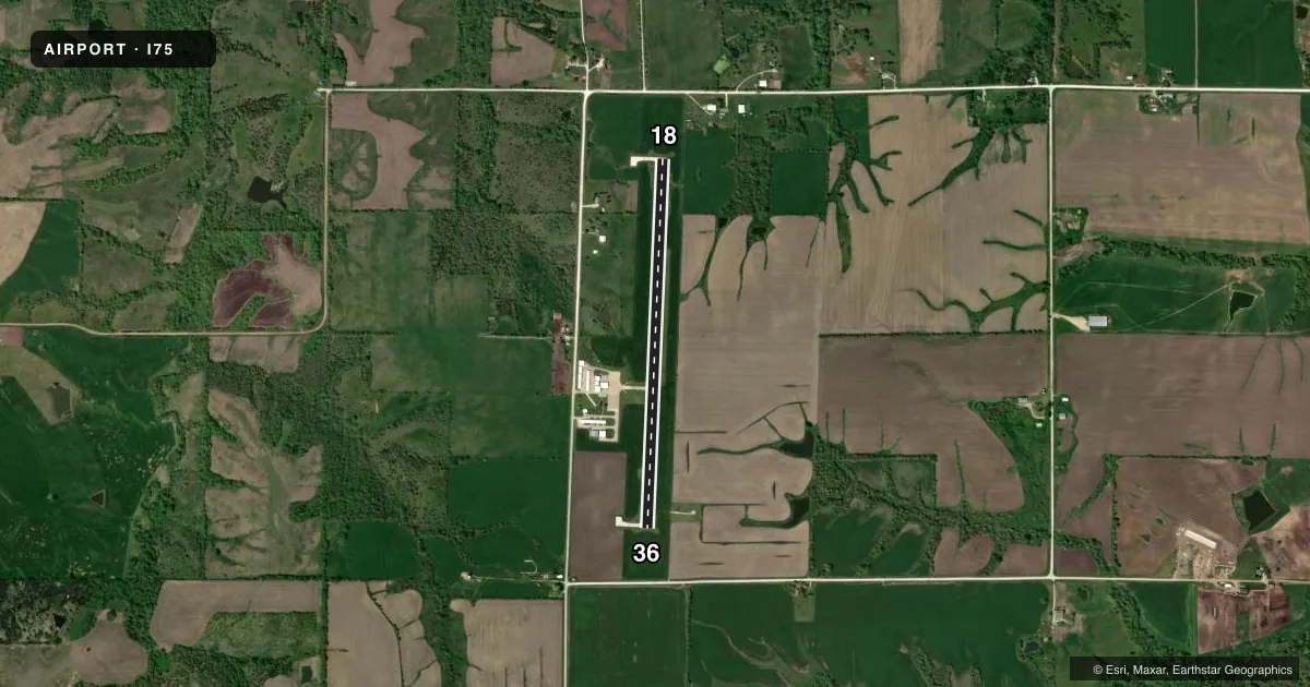
Runways & pattern
Full pagePattern entry · RWY 18
LEFT TRAFFICRunway end performance
| End | TORA | TODA | ASDA | LDA | VGSI | Approach lights | Obstruction |
|---|---|---|---|---|---|---|---|
| 18 | — | — | — | — | PAPI 2-box left(3°) | — | 73', tree, 2276' from thr, 21' R of cntrln, slope 28 |
| 36 | — | — | — | — | PAPI 2-box left(3°) | — | 15', road, 600' from thr, 0' R of cntrln, slope 26 |
Declared distances in feet. TORA = takeoff run available, TODA = takeoff distance, ASDA = accelerate-stop, LDA = landing distance.
Airport sketch
Runways drawn to scale from FAA survey coordinates, rendered over satellite imagery. Not for navigation.
Approaches & charts
Services on the field
Fuel grades, oxygen, maintenance, ramp storage and lighting — as declared to the FAA by the airport operator.
Fuel & services
- Fuel
- 100LL
- Airframe repair
- Not available
- Power plant repair
- Not available
Ramp & ground
- Transient storage
- Tie-down
- Hangar
- Lighting schedule
- SEE RMK
- Beacon schedule
- SS-SR
- Beacon
- White / Green (civil land)(WG)
- Wind indicator
- Lighted
- Segmented circle
- No
Fuel & FBOs
Cheapest 100LL and Jet A on the field and nearby. Always confirm with the FBO before taxi.
Airport notes
Surface conditions, obstructions, local procedures, lighting outages and other notes published with each FAA cycle.
General notes
- RY 18 IS CALM WIND RY.
- FOR CD CTC DES MOINES ATCT AT 515-974- 8016.
Lighting notes
- ACTVT MIRL RY 18/36; PAPI RYS 18 & 36 & REILS 18/36 - CTAF.
Fuel notes
- 100LL24 HOUR CREDIT CARD FUEL AVAILABLE
Other notes
- AIRSPACE DETERMINATION PENDING.
- MANAGEROFFICE PHONE NUMBER 641-342-7437.
VFR map & nearby airports
VFR sectional. Tap any ICAO chip to open that airport.
Key facts · I75
Answer card- ICAO
- I75
- Name
- OSCEOLA MUNI
- Location
- OSCEOLA, IOWA
- Elevation
- 1,115.2 ft MSL
- Traffic pattern altitude
- 2,115.2 ft MSL (1,000 AGL)
- Control tower
- Non-towered (use CTAF)
- Total runways
- 1
- Longest runway
- 18/36 · 4,001 ft
- Published ILS approaches
- 0
- Published frequencies
- 4
- Magnetic variation
- 3°
- Current flight rules
- VFR
- Current wind
- 200° at 8 kt
- Favored runway now
- RWY 18
Osceola Muni is in Osceola, Iowa. The field elevation is 1,115.2 ft MSL. It has one runway. Runway 18/36 is 4,001 ft long with concrete pavement. There is no control tower. The published pattern altitude is not listed, so use standard 1,000 ft AGL for light piston operations unless the current Chart Supplement says otherwise.
No ILS approaches are published here. The published remarks say runway 18 is the calm wind runway. Medium intensity runway lights are available on 18/36. PAPI is installed on both ends. REIL is also installed on both ends. Twenty-four hour credit card 100LL is available on the field through Osceola Municipal Airport. Call (641) 342-7437 for the office if you need current field details.
The airport sits in central Iowa. Airspace determination is still pending in the published remarks, so check the current Chart Supplement before you go. For clearance delivery, contact Des Moines Air Traffic Control Tower at 515-974-8016. Use CTAF 122.8 for local traffic. This is a simple one-runway field, but the elevation is high enough to keep an eye on density altitude on warm days. Runway 18 is the calm wind choice when conditions allow.