METAR & TAF KOXV
Current METAR
Observed 17:15Z
KOXV 271715Z AUTO 25007KT 10SM CLR 33/25 A2976 RMK AO2
- Wind
- 250° @ 7 kt
- Visibility
- 10 SM
- Temp / Dew
- 33°C / 25°C
- Altimeter
- 29.76 inHg
- Clouds
- CLR
- Density alt
- 3,509 ft
- Ceiling
- Unlimited
- Rules
- VFR
Airport info & contacts
Manager on record, flight service, ARTCC, attendance schedule and pattern altitude — published by the FAA and refreshed every 28 days.
Location
- From city
- 2 NM S
- VFR sectional
- OMAHA
- ARTCC
- ZMP · MINNEAPOLIS
- NOTAM facility
- OXV (NOTAM-D)
Airport manager
- Name
- KATHERINE SHAWVER
- Phone
- 702-466-9560
- Address
- 1770 S LINCOLN STREET, KNOXVILLE IA 50138
Flight service · Hours
- FSS FOD
- FORT DODGE1-800-WX-BRIEF
- Attendance
- DAWN-DUSK
Frequencies
Tap any row to copy the frequency to your clipboard.
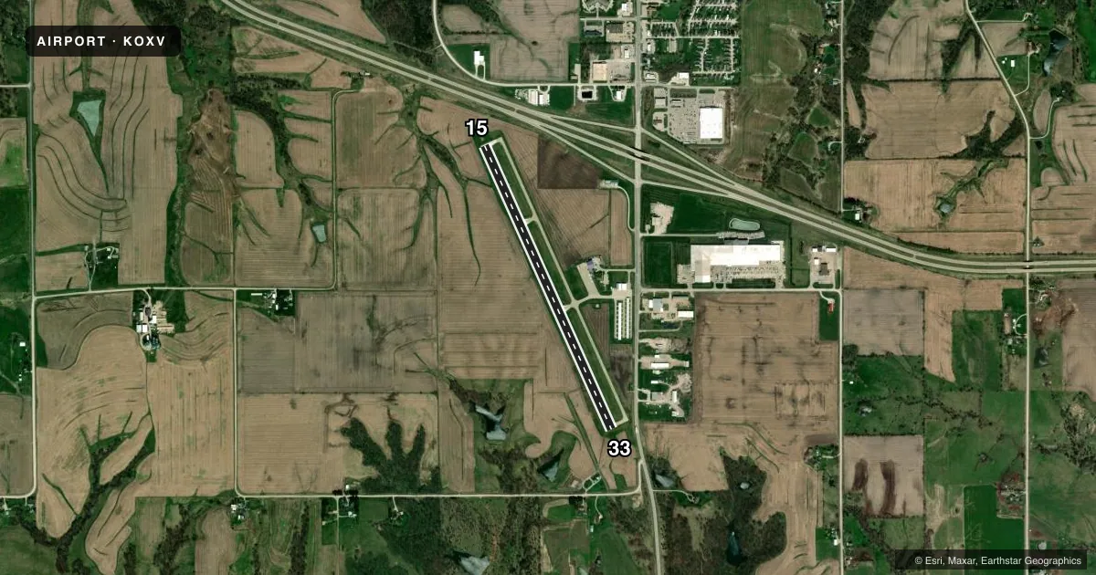
Runways & pattern
Full pagePattern entry · RWY 33
LEFT TRAFFICRunway end performance
| End | TORA | TODA | ASDA | LDA | VGSI | Approach lights | Obstruction |
|---|---|---|---|---|---|---|---|
| 15 | — | — | — | — | PAPI 2-box left(3°) | — | 26', pole, 819' from thr, 325' R of cntrln, slope 23 |
| 33 | — | — | — | — | PAPI 2-box left(3°) | — | 23', tree, 773' from thr, 99' R of cntrln, slope 24 |
Declared distances in feet. TORA = takeoff run available, TODA = takeoff distance, ASDA = accelerate-stop, LDA = landing distance.
Airport sketch
Runways drawn to scale from FAA survey coordinates, rendered over satellite imagery. Not for navigation.
Approaches & charts
Services on the field
Fuel grades, oxygen, maintenance, ramp storage and lighting — as declared to the FAA by the airport operator.
Fuel & services
- Fuel
- 100LLA
- Oxygen (bottled)
- Not available
- Oxygen (bulk)
- Not available
- Airframe repair
- Major
- Power plant repair
- Major
- Other services
- INSTR,RNTL,SALES
Ramp & ground
- Transient storage
- Tie-down
- Hangar
- Landing fee
- No fee published
- Customs
- Not available
- Lighting schedule
- SEE RMK
- Beacon schedule
- SS-SR
- Beacon
- White / Green (civil land)(WG)
- Wind indicator
- Lighted
- Segmented circle
- No
Fuel & FBOs
Cheapest 100LL and Jet A on the field and nearby. Always confirm with the FBO before taxi.
Airport notes
Surface conditions, obstructions, local procedures, lighting outages and other notes published with each FAA cycle.
General notes
- FOR CD CTC DES MOINES ATCT AT 515-974- 8016.
Lighting notes
- ACTVT MIRL RY 15/33 AND PAPI RYS 15 & 33 AND REIL RYS 15 & 33 - CTAF.
Other notes
- 1FOR SERVICE AFTER HOURS CALL 702-466-9560.
VFR map & nearby airports
VFR sectional. Tap any ICAO chip to open that airport.
Key facts · KOXV
Answer card- ICAO
- KOXV
- Name
- KNOXVILLE MUNI
- Location
- KNOXVILLE, IOWA
- Elevation
- 928.3 ft MSL
- Traffic pattern altitude
- 1,928.3 ft MSL (1,000 AGL)
- Control tower
- Non-towered (use CTAF)
- Total runways
- 1
- Longest runway
- 15/33 · 4,000 ft
- Published ILS approaches
- 0
- Published frequencies
- 4
- Magnetic variation
- 2°
- Current flight rules
- VFR
- Current wind
- 250° at 7 kt
- Favored runway now
- RWY 33
Knoxville Muni is in Knoxville, Iowa. The field elevation is 928.3 ft MSL. It has one runway, 15/33, with a longest length of 4,000 ft. There is no control tower. Traffic uses CTAF 122.8. The published pattern altitude is not listed, so use the standard 1,000 ft AGL pattern unless the current Chart Supplement says otherwise.
No ILS approaches are published here. That matters if you are planning an IFR arrival. Check the current Chart Supplement for the latest approach setup before you go. Knoxville Aviation is on the field. It carries 100LL and Jet A Prist. The published remarks also note that after-hours service is available by phone. Runway lighting is medium intensity on 15/33. PAPI is published for both runway directions. REIL is also published for both ends.
For a first-time arrival, the main things to know are simple. This is a non-towered airport with one concrete runway. Keep your eyes open in the pattern and on CTAF. If you need a clearance, contact Des Moines ATC using the published number in the Chart Supplement. The field sits just under 1,000 ft MSL, so performance planning should still account for local conditions and any summer density altitude.