METAR & TAF KPEA
Current METAR
Observed 17:15Z
KPEA 271715Z AUTO 26008KT 10SM SCT120 32/26 A2977 RMK AO2 T03160255
- Wind
- 260° @ 8 kt
- Visibility
- 10 SM
- Temp / Dew
- 32°C / 26°C
- Altimeter
- 29.77 inHg
- Clouds
- SCT
- Density alt
- 3,323 ft
- Ceiling
- Unlimited
- Rules
- VFR
Airport info & contacts
Manager on record, flight service, ARTCC, attendance schedule and pattern altitude — published by the FAA and refreshed every 28 days.
Location
- From city
- 1 NM W
- VFR sectional
- CHICAGO
- Pattern altitude
- 816 ft AGL · 1,701 ft MSL
- ARTCC
- ZMP · MINNEAPOLIS
- NOTAM facility
- PEA (NOTAM-D)
Airport manager
- Name
- SHANE VANDEVOORT
- Phone
- 641-628-9393
- Address
- 501 WEST 15TH STREET, PELLA IA 50219
Flight service · Hours
- FSS FOD
- FORT DODGE1-800-WX-BRIEF
- Attendance
- MON-SAT · 0700-DUSK
- SUN · 0900-1700
Frequencies
Tap any row to copy the frequency to your clipboard.
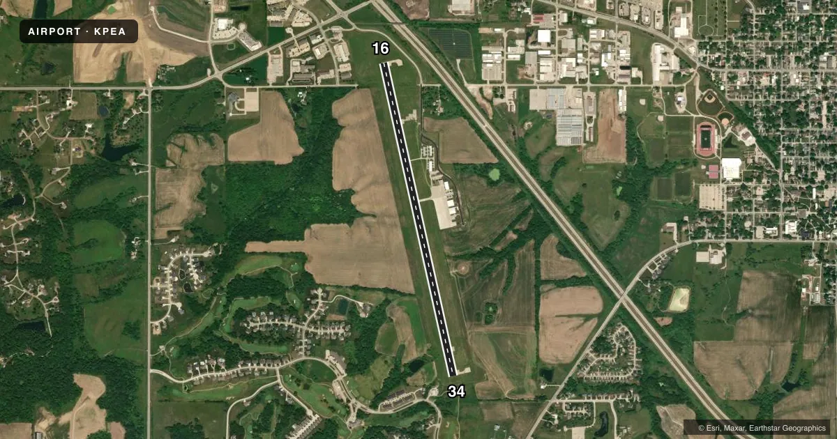
Runways & pattern
Full pagePattern entry · RWY 34
LEFT TRAFFICRunway end performance
| End | TORA | TODA | ASDA | LDA | VGSI | Approach lights | Obstruction |
|---|---|---|---|---|---|---|---|
| 16 | 5,400' | 5,400' | 5,200' | 5,000' | PAPI 2-box left(3.3°) | — | 32', tree, 527' from thr, 191' R of cntrln, slope 10 |
| 34 | 5,400' | 5,400' | 5,200' | 5,000' | PAPI 2-box left(3°) | — | 31', trees, 474' from thr, 188' R of cntrln, slope 8 |
Declared distances in feet. TORA = takeoff run available, TODA = takeoff distance, ASDA = accelerate-stop, LDA = landing distance.
Airport sketch
Runways drawn to scale from FAA survey coordinates, rendered over satellite imagery. Not for navigation.
Approaches & charts
Services on the field
Fuel grades, oxygen, maintenance, ramp storage and lighting — as declared to the FAA by the airport operator.
Fuel & services
- Fuel
- 100LLA
- Airframe repair
- Major
- Power plant repair
- Major
- Other services
- INSTR,RNTL
Ramp & ground
- Transient storage
- Tie-down
- Hangar
- Landing fee
- No fee published
- Lighting schedule
- SEE RMK
- Beacon schedule
- SS-SR
- Beacon
- White / Green (civil land)(WG)
- Wind indicator
- Lighted
- Segmented circle
- No
Fuel & FBOs
Cheapest 100LL and Jet A on the field and nearby. Always confirm with the FBO before taxi.
Airport notes
Surface conditions, obstructions, local procedures, lighting outages and other notes published with each FAA cycle.
General notes
- FOR CD CTC DES MOINES ATCT AT 515-974-8016.
Lighting notes
- MIRL RWY 16/34 PRESET LOW INTST; TO INCREASE INTST AND ACTVT PAPI RWY 16 & 34; REIL RWYS 16 & 34 - CTAF.
Approach & departure obstructions
- 16RWY 16 APCH SLP TO DTHR 22:1.
- 34RWY 34 APCH SLP TO DTHR 21:1.
Other notes
- PRVDD EACH APCH IS MAINTD FOR MIN 20:1 GLIDE SLOPE AND TRSNL SFC MAINTD FOR 7:1 SLOPE.
- ONLY APPLIES TO NON-TURBINE ACFT.
- 1AFTER HRS CALL 641-780-0244.
- MANAGEREMAIL ADDRESS: SHANE@FLYCLASSICAVIATION.COM (ALL LOWER CASE)
- MANAGERCELL PHONE 641-780-0244
VFR map & nearby airports
VFR sectional. Tap any ICAO chip to open that airport.
Key facts · KPEA
Answer card- ICAO
- KPEA
- Name
- PELLA MUNI
- Location
- PELLA, IOWA
- Elevation
- 884.8 ft MSL
- Traffic pattern altitude
- 1,700.8 ft MSL (816 AGL)
- Control tower
- Non-towered (use CTAF)
- Total runways
- 1
- Longest runway
- 16/34 · 5,403 ft
- Published ILS approaches
- 0
- Published frequencies
- 4
- Magnetic variation
- 2°
- Current flight rules
- VFR
- Current wind
- 260° at 8 kt
- Favored runway now
- RWY 34
Pella Muni sits in Pella, Iowa. The field elevation is 884.8 ft MSL. It has one runway, 16/34, which is 5,403 ft long with a concrete surface. The airport is not towered. Pattern altitude is 816 ft AGL, which is 1,700.8 ft MSL. No ILS approaches are published here, so plan with that in mind if the weather is marginal.
Classic Aviation is on the field. It carries 100LL and Jet A. CTAF and UNICOM are both 122.8. Des Moines Approach and Departure are on 123.9 and 307.15. For clearance delivery, contact Des Moines ATC tower. The published remarks also note that runway 16 and runway 34 lighting starts at low intensity. Use the runway end identifier lights on CTAF to bring the lights up and activate the PAPI.
There are a few runway environment items to brief before arrival. The approach to the displaced threshold on runway 16 has a 22 to 1 slope note. Runway 34 has a 21 to 1 slope note. The chart supplement also says the published pattern altitude applies to non-turbine aircraft. If you need anything after hours, call the airport manager number in the Chart Supplement before you launch.